
Articles
2019
Derek Schutt
2019-07-11
Wait, I could do geophysics—physics and math—and go outside?! That's the perfect combination.
Exploring a Changing Continent Using a Plate Boundary Observatory
2019-02-14
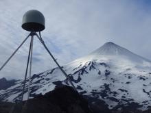
Geodesy is the science of measuring the size, shape, and gravity field of Earth, and how these change with time.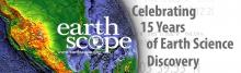
Fifteen Years of Earth Science Exploration
2019-02-14
The EarthScope National Office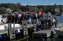
Reflections on the Accomplishments of EarthScope’s USArray
2019-02-14
The USArray has operated for over 15 years as a community science facility designed to address EarthScope’s goal of understanding the structure and evolution of the North American continent.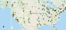
Education Corner: Final inSights Issue
2019-02-14
Sharing Science through the EarthScope Speaker Series and Save the Date for the EarthScope Legacy Education and Outreach Virtual Workshop
San Andreas Fault Observatory at Depth
2019-02-14
The Gold Standard for Scientific Drilling Through an Active, Continental Transform Fault
EarthScope Announcements
2019-02-13
inSights Final Issue February 20192018

New EarthScope Video!
2018-12-12
15 Years of Geoscience Discovery and Education in North America
EarthScope Top 10 Discoveries
2018-12-07
,
Redrawing the Map of the Midcontinent Rift
2018-09-04
EarthScope data is changing our views of this billion-year-old feature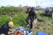
Alaska Amphibious Experiment Crosses the Shoreline
2018-08-31
New ocean-bottom seismometers complement the Transportable Array
PBO Station Highlight: A Puzzle in the Midcontinent
2018-08-31
What causes earthquakes in the interior of North America, far from plate boundaries?
Education Corner: 2018 ANGLE Teacher Workshop
2018-08-29
This issue features the first ANGLE educator workshop, which focused on giving educators tools for teaching about Alaska geoscience and community resiliency to tsunami and earthquake hazards.
EarthScope Announcements
2018-08-29
inSights Summer 2018
Rhiannon Vieceli
2018-07-10
Humans of EarthScope: “I like making interpretations about the earth, which is the common denominator for everyone.”
Media Advisory
2018-05-24
Science Educators Gather in Anchorage to Learn about Teaching and Preparing for Earthquakes, Tsunamis, and Volcanoes in Alaska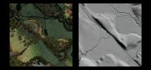
EarthScope’s Laser Vision: Sharing Lidar Data
2018-05-07
High-resolution images reveal fault movement—before and after quakes—to experts and students
EarthScope Announcements
2018-05-04
inSights Spring 2018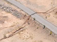
PBO Station Highlight: P496 Is Only One Piece of the Story
2018-05-04
PBO station P496 not only shook during the 7.2 El Mayor–Cucapah earthquake in northwestern Mexico, but moved permanently as a result of it.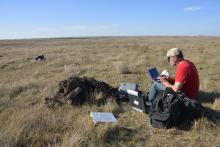
Mapping North America’s Magnetic Personality
2018-05-02
Completing a Cross-Country Dataset of Magnetotelluric Observations
Education Corner
2018-05-01
We explore the senses in this issue, from visual resources for current events-based lessons, to mapping with lasers, to learning about seismic waves through sound. Bonus materials: What wildlife sets off seismic sensors?
Emily Hopper
2018-03-06
Humans of EarthScope: "The stuff we’re researching is fundamental to how the whole planet functions."
Open SESAME
2018-01-29
EarthScope seismic research inspires landowners and students in Georgia
EarthScope Announcements
2018-01-29
inSights Winter 2017-18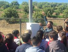
PBO Station Highlight
2018-01-29
Station OVLS introduces students to plate movement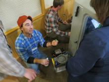
Inter-Agency Collaborations Take Center Stage at EarthScope Transportable Array Meeting in Alaska
2018-01-28
New Alaska data reaches beyond earthquakes
Rob Hawman
2018-01-24
I got into geology originally because I was always fascinated by the history of the earth.
Education Corner
2018-01-24
Science Fair season is coming soon, giving students a chance to explore hands-on science. (Photo by Molly Tedesche)
In every inSights issue, we feature a few of the dozens of
2017
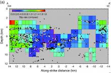
Creeps and starts on the San Andreas fault near San Juan Bautista
2017-11-10
Want to dig deeper? Click on the "advanced" button in the article for scientific details.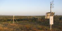
P472: Engineering for Earthquakes
2017-10-16
PBO Station Highlight October 2017EarthScope Announcements
2017-10-16
inSights Fall 2017
Education Corner
2017-10-12
In every InSights issue, ESNO features two of the dozens of tools, modules, and activities that utilize EarthScope data to benefit a wide variety of users (K–12, university educators, informal programs like museums or after-school programs).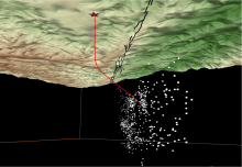
Tracking the Fluids in a Weak Fault
2017-10-12
EarthScope’s San Andreas Fault Observatory at Depth reveals the pathways of fluids carried along the fault’s fracture network
EarthScope's Transportable Array Spans Alaska, the Last Frontier
2017-10-12
Elliot Wilson of Pioneer Earthworks operates the drill at Alaska Transportable Array station D27M. Photo by Max Enders, IRIS.
A Writing Intern in the Field
2017-10-11
As the science writing intern for the EarthScope National Office, field work is not generally a part of my job..jpg?itok=UB8Zhy_G)
By road, boat, plane and helicopter: Creating a remote seismic measurement network
2017-10-03
Want to dig deeper? Click on the "advanced" button in the article for scientific details.
Data Tools
2017-08-24
Introducing a new how-to video series for accessing UNAVCO's geodetic data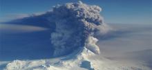
The Quiet After the Storm
2017-07-26
How EarthScope’s infrasound and seismic capabilities monitor evolving volcanic eruptions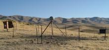
P085: Tiny Motions Matter
2017-07-25
PBO Station Highlight Summer 2017edited.jpg?itok=WcA_Q6ML)
Transportable Array Equips Stations with Infrasound Sensors
2017-07-25
by Andy Frassetto and Kasey Aderhold, IRIS - NSF # SAGE: 1261681, MRI-R2: 0960275 | Summer 2017
Observations of infrasonic signals have…

Summer 2017 Education Corner
2017-07-20
In every InSights issue, ESNO features two of the dozens of tools, modules, and activities that utilize EarthScope data to benefit a wide variety of users (K–12, university educators, informal programs like museums or after-school programs)EarthScope Announcements
2017-07-20
inSights Summer 2017
EarthScope's Final National Meeting
2017-06-16
A culmination of 15 years of expansive geoscience research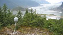
AB50: Quick Responder
2017-05-08
PBO Station Highlight May 2017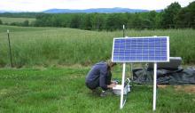
Earthquakes on a Passive Margin
2017-05-05
How EarthScope data help reveal the roots of anomalous seismic zones in the southeastern U.S.EarthScope Announcements
2017-05-05
inSights Spring 2017
Seismology in the Classroom
2017-05-05
A new online course connects teachers across Alaska to real-time seismic data
Spring 2017 Education Corner
2017-05-05
In every InSights issue, ESNO features two of the dozens of tools, modules, and activities that utilize EarthScope data to benefit a wide variety of users (K–12, university educators, informal programs like museums or after-school programs)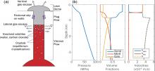
Probing volcanic systems with Bayesian inversion using physics-based models
2017-04-24
Science Nugget - By Paul Segall (Stanford University), Ying-Qi Wong (Stanford University), Kyle Anderson (U.S.G.S.) - NSF # EAR 1358607 | 2014-2017
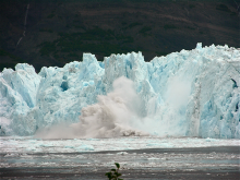
Calving Season
2017-04-03
How EarthScope seismometers help track glacier breakdown
EarthScope National Meeting 2017
2017-03-09
The last EarthScope National Meeting will be held in Anchorage, Alaska from May 16-18, 2017.EarthScope Announcements
2017-02-01
inSights Winter 2017
Salt Canyon, California
2017-02-01
PBO Station P208 watches the grass grow...literally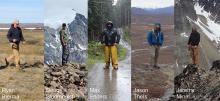
The Alaska Transportable Array Team
2017-02-01
Achieving Success in Challenging Environments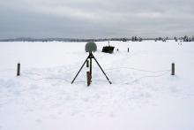
Improving Snow-Depth Forecasting with EarthScope’s Plate Boundary Observatory
2017-02-01
by Gail McCormick - Winter 2017
Winter 2017 Education Corner
2017-02-01
In every InSights issue, ESNO features two of the dozens of tools, modules, and activities that utilize EarthScope data to benefit a wide variety of users (K–12, university educators, informal programs like museums or after-school programs)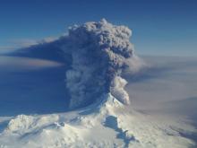
Volcano study examines relationship between seismic signals, sound waves
2017-01-23
By Sue Mitchell - University of Alaska Fairbanks Press Release - January 17, 2017 (http://news.uaf.edu/hearing-a-volcanic-plume/)
A study of relationships between seismic signals and sound
2016
Fall Creek, Oregon
2016-10-24
Borehole strainmeter B030 records slip around the world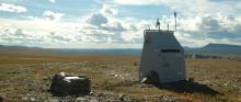
Driving the Dempster
2016-10-24
The Transportable Array deploys along a remote Canadian “highway”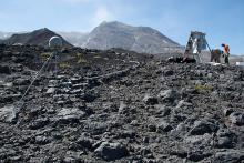
Watching a Volcano Breathe
2016-10-24
Plate Boundary Observatory monitoring networks on Mount St. Helens
The Multi-Chambered Heart of Mount St. Helens
2016-10-24
Enhancing earthquake detection and imaging beneath the volcano
Fall 2016 Education Corner
2016-10-23
For every InSights issue, we feature two of the dozens of tools, modules, and activities that utilize EarthScope data to benefit a wide variety of users. We intend to reach K–12 and university educators, as well as informal programs like museums.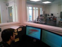
Good Times, Better Ages
2016-10-11
How the EarthScope AGeS program evolved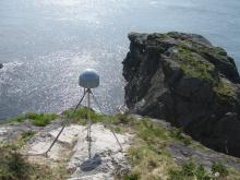
Triangulation Point, Oregon
2016-10-10
PBO Station P405 battles the elements at an energetic plate boundary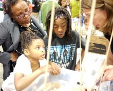
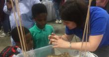
Getting Hands On With EarthScope
2016-10-10
By ESNO - Spring 2016
"Wow, it's moving!" was called out frequently in the busy hall that housed the largest (and free!) national science festival. More than 365,000 people of all ages and
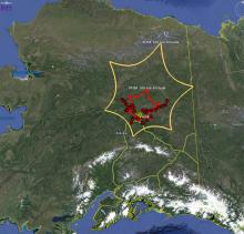
Creeping Calamity
2016-09-20
Using the Plate Boundary Observatory to monitor landslide motion. GPS Station AC55 in Alaska was moving more than expected. Some movement was normal due to tectonic plate movement and residual motion from previous earthquakes—other GPS stations...
A Magnetic Meeting of Space and Earth
2016-09-20
Magnetic storms, triggered by the interaction of the solar wind with Earth’s magnetosphere, not only produce our aurora light shows, but can also induce electric fields in our planet’s subsurface.
Summer 2016 Education Corner
2016-09-20
Over the years, an array of tools, modules, and activities applying EarthScope scientific data have been developed for a wide variety of users. K–12 and university educators, or informal programs like museums, can benefit from these resources.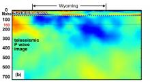
Recent Craton Growth by Under-accreting an Ocean Plateau Beneath Wyoming
2016-09-20
Science Nugget - By Eugene Humphreys (University of Oregon Eugene) and Robert van der Hilst (MIT) - NSF # EAR 952194 | 2010-2012
Seismic tomography images high-velocity…

Crustal Strength Profiles Across the Brittle-Ductile Transition
2016-09-20
Science Nugget - By John Platt (University of Southern California) and W. M. Behr (University of Texas Austin) - NSF EAR # 0809443 | 2008-2012
In this project we…
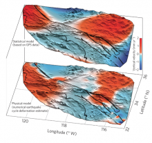
The Vertical Fingerprint of Earthquake Cycle Loading in Southern California
2016-09-19
Science Nugget - By Bridget Smith-Konter (University of Hawaii at Manoa), David Sandwell (Scripps Institution of Oceanography), Xiaopeng Tong (University of Washington…
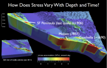
Locked, Loaded and Looming?
2016-09-19
Exploring earthquake cycle stress history of seismically active faults of the San Andreas Fault System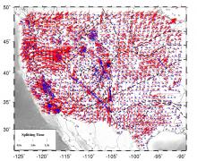
Mantle Anisotropic Structure and Dynamics Beneath the Western United States
2016-09-19
Constraints from Shear-wave Splitting Analysis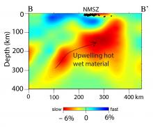
Hot, Wet Mantle Below the New Madrid Seismic Zone
2016-09-19
Science Nugget - By Charles Langston (University of Memphis), Christine Powell (University of Memphis), Steve Horton (University of Memphis), Heather Deshon (Southern Methodist…,
Lights, Cameras, Action!
2016-09-19
EarthScope Stories Chronicled on Video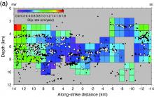
Imaging of Slow Fault Movements with Microearthquakes
2016-09-19
Variability of Fault Slip Behavior Along the San Andreas Fault in the San Juan Bautista Region
Uppermost mantle seismic velocity structure beneath USArray
2016-09-19
Science Nugget - By Jeanine Buehler (University of California San Diego) and Peter Shearer (University of California San Diego) - NSF EAR # 1358510 | 2014
We…
IRIS 2016 Workshop
2016-09-01
Highlights Emerging Fields and Technologies in Seismology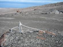
Augustine Island, Alaska
2016-08-10
PBO Station AV03 Takes a Blow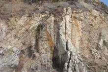
2016 AGeS Awardees
2016-07-01
Summer 2016
The EarthScope AGeS (Awards for Geochronology Student Research) program is a multi-year educational initiative aimed at enhancing interdisciplinary, innovative, and high-impact
To Boldly Go… EarthScope Firsts in Alaska
2016-05-20
While staying true to its intent as a telescope to peer into Earth’s interior, EarthScope has also been looking up to the heavens.
2016 UNAVCO Science Workshop
2016-04-15
New Uses for the Plate Boundary Observatory2015
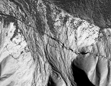
Drawing Lines from the Air
2015-12-22
High-resolution Topographic Data Comes of Age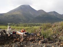
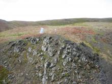
Mackenzie Mountains Mystery: New EarthScope Project Peers Underneath an Unlikely Mountain Range
2015-12-22
By Kerry Klein - Winter 2016
At first blush, the Mackenzie Mountains in northern Canada could be the Rocky Mountains’ long lost sibling. They appear just as angular and…
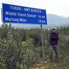
Supporting Earth Science in the Canadian Sub-Arct
2015-12-01
By Justin Sweet - Winter 2016
Canada’s Yukon and Northwest Territories are not known as hospitable land. This sub-arctic region, home to the Mackenzie Mountains project, presented
Back to Mothership
2015-12-01
How PBO data get from Everywhere to somewhere
The Cascadia Initiative: A Sea Change in Seismolog
2015-11-19
By Cascadia Initiative Expedition Team (CIET)[http://cascadia.uoregon.edu] - Winter 2015
The increasing public awareness that the
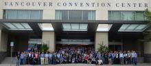
ES National Meeting, June 2015
2015-10-13
By ESNO - Fall 2015
The 2015 EarthScope National Meeting in Stowe, Vermont showcased pioneering EarthScope studies in poster and talk sessions, preceded by an optional pre-meeting field
Fall 2015 Announcements
2015-10-01
Meet the New EarthScope National Office
Over the next four years, the EarthScope National Office (ESNO) at the University of Alaska Fairbanks will focus on bringing EarthScope science to
Alaska Bound
2015-09-22
Transportable Array migrates northward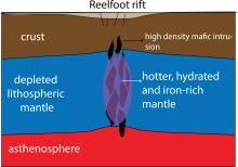
Underground Clues Help Explain an Old Earthquake Mystery
2015-09-19
By Adam Mann - Fall 2015
In 1811 and 1812, the New Madrid earthquakes destroyed homes and buildings through northeast Arkansas and the Missouri Bootheel. According to…
Low-Cost Additions to the Plate Boundary Observatory for Earthquake Early Warning
2015-04-15
By Doerte Mann and Beth Bartel - Spring 2015
One of the major benefits of the Plate Boundary Observatory (PBO) is its contribution to prototype Earthquake Early Warning systems (EEW).
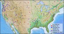
The Legacy of the USArray Transportable Array
2015-04-13
By Andy Frassetto, IRIS - Spring 2015
In the fall of 2003, before EarthScope began, approximately 200 modern broadband seismic stations operated across the contiguous United States,
A Coast-to-Coast View of the Mantle Beneath the United States
2015-04-01
By Brandon Schmandt, University of New Mexico and Fan-Chi Lin, University of Utah - Spring 2015
One of the major observational components of the EarthScope program is the…
EarthScope Science and Disaster Preparedness
2015-01-14
Engaging Educators in EarthScope Science and Disaster Preparedness Through Professional Development Workshops in Coastal Cascadia2014
The EarthScope Decade Symposium
2014-10-14
Celebrating Ten Years of Geoscience Accomplishments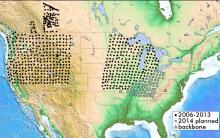
USArray Continues Field Activities in 2014
2014-10-14
By Perle Dorr, IRIS - Summer 2014
Since the completion of the Transportable Array in the Lower 48 during fall 2013, USArray has focused on the creation of the Central and Eastern US
New Active Earth Monitor Content Set
2014-10-14
Midcontinent Rift Available in Spring 2015
Teaching Educators: PBO Data and Classroom Resources
2014-10-14
by UNAVCO - Fall 2014
Workshop Report: Modern and Ancient Basement Arches and the Connection to Flat Slab Subduction
2014-09-22
By Megan Anderson (CC), Kate Miller (TAMU), Susan Beck (UA), and Margarete Jadamec (UH) - Fall 2014
The structural dissimilarity between basement-involved arches and thin…
New EarthScope Geochronology Graduate Student Research and Training Program
2014-09-22
Organizers: Rebecca Flowers (CU), Ramon Arrowsmith (ASU), Jim Metcalf (CU), Blair Schoene (Princeton), Tammy Rittenour (USU) - Fall 2014
The EarthScope Institute on…
Using the Midcontinent Rift as a Unifying Theme for Park Interpreters and Educators
2014-09-22
By Seth Stein, Carol Stein, and Eunice Blavascunas - Fall 2014
One of EarthScope’s major targets is the Midcontinent Rift (MCR), a 1.1 billion-year-old scar along which…
Transportable Array Contributes to the Central and Eastern US Network
2014-03-22
By Perle Dorr, IRIS - Spring 2014
The National Science Foundation is funding the creation of a Central and Eastern US Network (CEUSN) for the purpose of obtaining long-…
Earthquakes and Human Activities Addressing Public Concerns
2014-03-22
North Texas Earthquake Study Group, Southern Methodist University - Spring 2014
There is currently public, scientific, and policy concern regarding the recent increased…
Stability of PBO GPS Monument Types
2014-03-22
Project Highlight
PBO Weighs California’s Water Resources
2014-02-20
By Donald Argus, Yuning Fu, and Felix Landerer - Summer 2014
Approximately 500 sites in California, most of which are part of the Plate Boundary Observatory, are weighing…
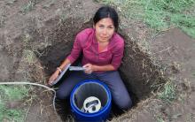
Helicopter Fieldwork in the PBO Alaska Region
2014-02-02
By Ellie Boyce - Summer 2014
With high-elevation GPS stations melting out of the snow and the weather becoming milder, the PBO Alaska region began annual helicopter-based…
New Flexible Array Video Series
2014-01-01
By ESNO - Winter 2014
Geology might not be the first thing that comes to mind if you heard the names SESAME, CAFÉ, SUGAR, and OIINK, but these are just a few examples of…
2013
Hitting Hot Water with PBO Borehole Strainmeters in the Yellowstone Caldera
2013-12-22
By Glen Mattioli and David Mencin - Winter 2014
Data from the Yellowstone Gladwin Tensor strainmeter (GTSM) network are improving the understanding of the structure of…
USArray Reaches the East Coast
2013-12-22
By Maureen Long and Vadim Levin - Winter 2014
On October 1st 2013 the seismic and magnetotelluric observatory network USArray, which is a key element of the EarthScope…
EarthScope Northeastern Interpretive Workshop
2013-09-22
By ESNO - Fall 2013
Twenty-six interpretive professionals listened intently as Park Ranger Stephanie Kyriazis (photo) relayed the glacial history of Acadia National Park…
USArray Looks Back as it Looks Ahead
2013-09-22
By IRIS - Fall 2013
Ten years ago, the construction of USArray observatories officially began. This followed numerous community meetings, countless hours of meticulous…
Monitoring Surface Deformation at Long Valley Caldera, California
2013-09-22
By Kang Hyeun Ji - Fall 2013
Continuous monitoring of volcanic activity provides a way to detect changes from usual activity, provide warning impending eruptions, and…
PBO Multiple Monument Comparison Project
2013-06-22
By UNAVCO - Summer 2013
PBO Change Order 35 authorized UNAVCO to construct two additional geodetic monuments at five existing PBO stations in order to test and compare…
SPREE: A Seismic Study of Continental Modification
2013-06-22
Trevor Bollmann, Emily Wolin, Suzan van der Lee, and the SPREE Team - Summer 2013
Northwestern University, Washington University in St. Louis, the University of Minnesota…
USArray - Alaska Deployment Planning
2013-06-22
Terry Pavlis, UTEP - Spring 2013
On February 19 and 20 approximately 50 geoscientists met at the Pacific Geoscience Center in Sydney, British Columbia, to discuss…
USArray Infrasound Data Products at IRIS
2013-06-22
By Manochehr Bahavar and Chad Trabant - Summer 2013
Diverse natural and man-made acoustic sources such as large explosions, rocket launches, and meteorites can act as…
USArray Status
2013-03-22
By Perle Dorr, IRIS
With operating stations blanketing the southeastern states, the Transportable Array is on target to complete its journey across the contiguous US and…
Deformation of the Wasatch Fault System
2013-03-22
Plate Boundary Observatory Data
Chelyabinsk Meteor lit up the Transportable Array
2013-03-22
By Catherine D. de Groot-Hedlin and Michael Hedlin - Spring 2013
The large meteorite that entered Earth's atmosphere above Chelyabinsk, Russia last month drew attention…
InTeGrate: Interdisciplinary Teaching of Geoscience for a Sustainable Future
2013-01-01
Cathryn A. Manduca - Winter 2013
InTeGrate is an NSF sponsored community effort to support the teaching of geoscience in the context of societal issues both within…
Chlorite-Smectite Clay Minerals and Fault Behavior
2013-01-01
Evidence from the San Andreas Fault Observatory at Depth (SAFOD)
USArray Detects Hurricane Sandy
2013-01-01
By IRIS - Winter 2013
The USArray’s Transportable Array (TA) seismometers and barometers have documented ground motion and atmospheric pressure changes due to Hurricane…
2012
EarthScope National Office Hosts EarthCube Conference
2012-09-22
By Dr. Mike Gurnis, Caltech - Fall 2012
Sixty scientists met at Arizona State University on October 29 and 30 and discussed the current state and future potential for the…
PBO GPS Updates
2012-09-22
By Glen Mattioli, UNAVCO - Fall 2012
Currently, there are 1120 GPS sites and 28 tilt meters, as well as numerous other strainmeters actively measuring deformation. In…
Understanding Continental Evolution using Data from the Transportable Array
2012-09-22
By Dr.Hersh Gilbert - Fall 2012
Do high mountains possess thick roots of low-density crust that keep them a"oat in the denser mantle, or do zones of low-density mantle…
EarthScope Interpretive Workshop - Central Appalachian Region
2012-06-22
Photo above, courtesy of Wendy Taylor
Hosted by James Madison University (JMU) and organized by ESNO, this workshop featured…
EarthScope and Place-Based Education
2012-06-22
By Steven Semken - Summer 2012
When we affix meaning to any physical locality—by naming it, building a home there, exploring its geology and geophysics as EarthScope…
EarthScope and GeoPRISMS Complimentary Research and Joint Planning
2012-06-01
By Ramon Arrowsmith, ESNO Director - Summer 2012
A balance between EarthScope-centric data gathering, science, and the interests and capabilities of other complementary communities is
Mineral, VA Earthquake Demonstrates the Passive Aggressive Margin of Eastern North America
2012-03-22
By Meghan Berg - Spring 2012
On August 23, 2011, the Mw 5.8 Mineral, Virginia, earthquake rocked the east coast of the U.S. While moderate in comparison to recent mega-…
Tales from the Field: PBO Installation in Alaska
2012-03-22
Max Enders - Spring 2012
When UNAVCO set about building the Earthscope Plate Boundary Observatory (PBO) no challenge was nearly as daunting as the prospect of installing…
EarthScope Social Media Blitz
2012-03-22
By ESNO - Spring 2012
Social media sites have emerged as a popular and effective form of communication among all age groups, with more than half of the teenage and adult…
Spring 2012 Facilities Status
2012-03-22
Spring 2012
USArray Status
The Transportable Array (TA) continues to roll eastward across the US. Having crossed the Mississippi River in March 2011, the TA will…
2011
EarthScope Participates in Open Data Seismic Deployment Following 2010 Chile Earthquake
2011-12-22
The global seismology community established a new model of international cooperation in response to the great Chile earthquake of February 27, 2010. The adaptable framework is geared to produce a high-quality, open-access data set of seismic waveforms col
Seismic Tomography with USArray Data
2011-08-16
In its July 2011 issue, Popular Science ranked EarthScope the “most epic” big science project because of its ambitious scope: Exploration of the deep geologic structure and evolution of an entire continent.
Fluid Pressure Spikes in SAFOD Rocks as Evidence of Microseismicity
2011-03-22
The San Andreas Fault (SAF) deforms by permanent creep and microseismicity in central California. Higher-thanhydrostatic fluid pressures, which could explain low strength and creep, were not detected during the San Andreas Fault Observatory at Depth (SAFO2010
Using GPS to Measure Soil Moisture, Snow Depth and Vegetation Growth
2010-09-22
GPS data collected as part of PBO, though, contain additional information that is very useful in ways unforeseen when the original PBO science plan was created.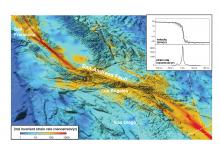
Integrating GPS & InSAR to Resolve Stressing Rates Along the San Andreas System
2010-09-16
By Bridget Smith-Konter, David T. Sandwell, and Meng Wei - Summer 2010
New estimates of seismic hazard (e.g., UCERF, http://www.scec.org/ucerf) will rely on high…, ,
Figure 2: Interferogram of the April 2010 earthquake in Baja California, Mexico, from ALOS PALSAR (Advanced Land Observing Satellite Phased Array type L-band Synthetic Aperture…, , ,
Figure 3: Remove-stack-restore interferograms for the Salton Sea area. (a) Physical model constrained by GPS data. (b) Stacked residual interferograms after applying the…,
References
Bird, P. (2009), Long-term fault slip rates, distributed deformation rates, and forecast of seismicity in the western United States from joint fitting of…
U-Pb Thermochronology: 4-Dimensional Imaging of the North American Lithosphere
2010-03-22
As the USArray Transportable Array marches eastward, seismic images are providing ever more detailed insight into present day structures of the crust and mantle beneath North America. But how old are these structures and what do they tell us about the geo

