
The EarthScope Speaker Series was part of the larger EarthScope Education and Outreach program and sought to present the scientific results of EarthScope researchers to faculty and students in departmental seminars at colleges and universities. Speakers were selected based on their outstanding research accomplishments involving EarthScope as well as their abilities to engage a variety of audiences. Each Speaker presented science-based lectures on their own EarthScope-related project, and their talks included an introduction highlighting broader EarthScope objectives and accomplishments.
"The speaker series exposed our students to a discipline that they are not accustomed to;" "Our students are not regularly exposed to scientific research, much less high-caliber, cutting edge research. We'll be talking about his talk for some time."; "Expressing the contribution of EarthScope and its available data is always a great reminder for the faculty and grad students in the department."; ". . .very valuable in terms of collaborative connections and collegial outreach."
Information on past Speakers' bios and talks, as well as program goals and guidelines are posted below.
To inform the public, research, and education communities about EarthScope and exciting research activities and opportunities.
To allow the public, researchers and students to meet and interact with EarthScope scientists, both by attending their lectures but also through informal discussions with Speakers.
To enable EarthScope Speakers to meet a wide range of researchers, students, and others whom they might not otherwise have the chance to meet.
To bring EarthScope research and the EarthScope community to smaller institutions that might not have regular scientific talks.
Be generous with advertising! This is important for any Speaker Series presentation but most crucial for any public lectures! Get the word out by producing and posting flyers, informing other local institutions/organizations like schools and colleges (including museums, science centers, libraries, parks, etc.), interested civic groups and relevant professional organizations. This may require more than just announcing by email or posting on your department’s web page.
Encourage local researchers, faculty, staff, and students to meet with the Speaker before or after the talk. Prepare a schedule for the visit so the Speaker and members of the host institution can plan their days accordingly.
Be flexible in your scheduling, especially when planning meetings and appointments. Speaker Series Speakers are taking time out of their work and busy schedules to travel on behalf of the EarthScope Program and the National Science Foundation to present exciting work. Please work with the Speaker in advance. If you have very specific presentation requests, please note them in your Speaker Series host application. We will try to accommodate such requests when possible.
Make time for researchers, faculty, staff, and students to attend. Don't schedule the lectures against important classes or at times when they will be lightly attended such as late on Friday afternoons or during lunch unless these are regular seminar times.
Consider organizing group discussions and/or meals to have the Speaker with groups of students as well as researchers and faculty. The Speakers may be delighted to discuss career options, research strategies, personal field experiences, and more, offering learning opportunities for everyone.
Airfare will be covered by EarthScope National Office. Host Universities are expected to cover the cost of ground transportation, lodging, and meals. However, if your schools do not have a budget, please let the EarthScope National Office know what your institution will be able to cover so travel needs can be met accordingly.
Alternatively, if your institution has the budget and wishes to support the Speaker by arranging travel, just make sure to notify the EarthScope National Office in advance.
Because the Speakers are volunteering their time, the EarthScope National Office organizes all travel arrangements in collaboration with the host institution.
SPEAKERS 2018-2019
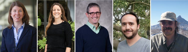
From left to right: Colleen Dalton (Associate Professor, Brown University); Melissa M. Moore-Driskell (Associate Professor of Geology, Associate Dean of Honors College, University of North Alabama); Chris Marone (Professor, Pennsylvania State University); Diego Melgar (Associate Professor, University of Oregon); Basil Tikoff (Professor, University of Wisconsin - Madison).
Dr. Colleen Dalton: Associate Professor, Department of Earth, Environmental and Planetary Sciences | Brown University
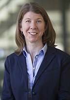 Colleen Dalton is an Associate Professor in the Department of Earth, Environmental and Planetary Sciences at Brown University. Her research is focused on using seismic waves to image the Earth’s crust and mantle in order to determine the three-dimensional distribution of temperature, composition, partial melt, and volatile abundance. Colleen has developed new approaches that utilize seismic-wave amplitudes to image seismic attenuation. Her research also combines geophysical observations together with observations from other geoscience disciplines, such as geochemistry and mineral physics, to produce a more complete picture of the planet’s interior. She was awarded an NSF CAREER grant from the EarthScope program in 2016. Colleen received her B.S. in Geology/Physics-Math from Brown University and her Ph.D. in Geophysics from Harvard University. She was a postdoctoral fellow at the Lamont-Doherty Earth Observatory at Columbia University and an assistant professor in the Department of Earth Sciences at Boston University before joining the Brown faculty in 2014.
Presentation: The evolution of a continent as revealed by seismic-wave attenuation
The North American continent contains vastly diverse geology: volcanoes and mountains in the west, interior plains, and broad hills in the east. This topography reflects the episodes of continental collision, breakup, and modification that the land mass has experienced over billions of years. The movements of tectonic plates at Earth’s surface are inextricably linked to convection in Earth’s mantle. Understanding the connection between the Earth’s interior and surface is essential to addressing fundamental questions about how continents are created, how they evolve over time, and how they are destroyed.
In this talk I will discuss how the energy loss (attenuation) experienced by seismic waves can be used to image the properties of the crust and mantle beneath North America and, by extension, the evolution of the continent. While it is generally acknowledged that seismic attenuation has the potential to be a valuable source of information about the Earth’s interior, it is difficult to isolate attenuation from other wave-propagation phenomena, which has historically limited its use by researchers. The EarthScope USArray seismometers have recorded what is likely the best data set in existence to confront many of the challenges that typically plague investigations of surface-wave attenuation. I will also show how jointly interpreting models of seismic attenuation and velocity together with laboratory measurements of these quantities can constrain the variations in temperature, composition, partial melt, and water in the North American upper mantle.
Dr. Melissa M. Moore-Driskell: Associate Professor of Geology, Associate Dean of Honors College, Department of Physics & Earth Science | University of North Alabama
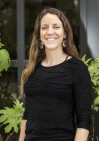 Melissa Moore-Driskell is an Associate Professor in the Department of Physics & Earth Science and Associate Dean of the Honors College at the University of North Alabama. Melissa is a seismologist, and her research focuses on using seismic waves to determine the structure of subduction zones to better understand seismogenic processes and dynamics. She is currently Co-PI on a research project in southern Alaska (SALMON: Southern Alaska Lithosphere and Mantle Observatory Network), an EarthScope Flexible Array experiment. The science objective of SALMON is to use local and teleseismic earthquakes to image the seismic structure of the crust and upper mantle to better understand the active tectonic setting and the tectonic history of the Cook Inlet region. Melissa received her BS in geology at the University of North Alabama and her MS in geophysics from Arizona State University where she studied anisotropy of the Core-Mantle Boundary. She earned her PhD in geophysics from the Center for Earthquake Research and Information (CERI) at the University of Memphis where she researched seismogenic zone structure of the Nicaraguan and Costa Rican subductions zones using local earthquake tomography.
Presentation: Planes, Boats, Bears, and Undergrads: Adventures in Alaskan Seismic Fieldwork
From the southern coast and Aleutians Islands to Denali and the Alaska Range to the Brooks Range, Alaska is the most seismically and tectonically active state in the US. The second most powerful earthquake ever recorded was the Great Alaskan Earthquake in 1964. The Alaska Earthquake Center detects, on average, an earthquake every 15 minutes, reporting over 150,000 earthquakes in the last 5 years. The most seismically active area is dominated by a 4,800 km long active tectonic boundary between the Pacific and North American Plates. Along southern Alaska this manifests as the Alaskan subduction zone, where the Pacific Plate is subducting, or sliding beneath the North American Plate. Most of the seismic activity in southern Alaska occurs as major earthquakes that rupture the plates along the megathrust, the shallow part of the thrust interface between the subducting and overriding plates. Not only does Alaska exhibit widespread and abundant seismicity but the state has diverse and complicated geologic processes related to flat slab subduction of thick ocean crust. Despite the immense amount of seismicity, much of the state has remained unmonitored due to its rugged and remote nature.
In this talk, I will discuss Alaska seismicity and the deployment of the USArray in Alaska (2014-2019) and supplemental FlexArray Experiments used to conduct new research into the structure of the Earth beneath Alaska. I will also provide an overview of my fieldwork for the SALMON experiment, which incorporates the research of undergraduate field assistants. USArray is an ambitious 15-year program to install a dense network of seismometers across the United States in order to examine both structure and dynamic activity beneath the continent. Beginning in the western United States, 400 portable instruments (TA) are placed in a region for 2 years, and then shifted to the next region until the array has been deployed across the entire continental US. The TA is now installed in Alaska for the final phase of deployment. The TA has already improved the detection of earthquakes in Alaska and will provide improved imaging of the region. My project, SALMON (Southern Alaska Lithosphere and Mantle Observatory Network), is a FlexArray seismic experiment in southern Alaska which consists of 29 broadband stations in the Cook Inlet region. The science objective is to use local and teleseismic earthquakes to image the seismic structure of the crust and upper mantle to better understand the active tectonic setting and the tectonic history of the Cook Inlet region. Most of our station locations were remote and required the use of boats, planes, helicopters, and ATVs. The SALMON project posed considerable challenges for station installation, notably roadless regions, difficult access in Cook Inlet due to strong tides, mudflats, and large rocks, swampy areas with shallow water tables, and seasonal freeze/thaw, in addition to active bear populations.
Dr. Chris Marone: Professor, Department of Geosciences | The Pennsylvania State University
 Chris Marone is professor of Geophysics in the Department of Geosciences at The Pennsylvania State University. He runs the rock mechanics lab at Penn State and specializes in design and construction of equipment for high-resolution measurement of rock properties under unusually well controlled conditions and complex loading history. His main interests are in earthquake physics, granular mechanics and friction. Marone co-directs the Center for Geomechanics, Geofluids, and Geohazards and is associate director of the Institute for Natural Gas Research at Penn State. Chris did undergraduate work at SUNY Binghamton and graduate study at Lamont/Columbia University. He spent time as a post-doc at Melbourne University and the CSIRO Division of Geomechanics, was an adjunct prof at UC Berkeley and served on the faculty at MIT before moving to Penn State. He enjoys teaching and every spring gears up to teach an introduction to oceanography to 700+ students. Marone’s research group is known for investigating friction laws for seismic and aseismic faulting and for illuminating the complex set of processes that govern the rheology of brittle deformation.
Presentation: The Mechanics of Slow Earthquakes and the Spectrum of Fault Slip Behaviors
Earthquake science is in the midst of a revolution. Our understanding of tectonic faulting has been shaken to the core by the discoveries of seismic tremor, low frequency earthquakes, slow slip events, and other modes of fault slip that were thought to be non-existent and theoretically impossible only a few years ago. Despite the growing number of observations of slow earthquakes and the fact that they can trigger catastrophic large earthquakes their origin remains unresolved. Basic questions remain regarding how slow ruptures can propagate quasi-dynamically, at speeds far below the Rayleigh wave speed, and how tectonic faults can host both slow slip and dynamic earthquake rupture. In this talk I focus on recent results showing that we can reproduce the complete spectrum of fault slip modes in the lab, ranging from stick-slip to creep-slip. The lab results correspond to fault behaviors ranging from elastodynamic rupture to low frequency earthquakes and aseismic fault creep. I also discuss our work on the evolution of elastic wave speed during the laboratory seismic cycle, which shows precursory changes of wave speed prior to both slow and fast lab earthquakes. Our results suggest that slow earthquakes and transient fault slip behaviors can arise from the same governing frictional dynamics as ordinary earthquakes. The mechanics of slow slip in the lab result from fault creep prior to failure and transient frictional strengthening during nucleation of dynamic instability. These processes could act in concert with other mechanisms that have been proposed for slow earthquakes, including fault zone dilatancy, which may help explain the broad range of geologic environments where slow earthquakes have been observed.
Dr. Diego Melgar: Associate Professor, Department of Earth Sciences | University of Oregon
 Diego Melgar is Assistant Professor of geophysics at the Department of Earth Sciences at the University of Oregon. Diego graduated from the Scripps Institution of Oceanography in 2014 with a Ph.D. in geophysics. There he researched the role of GNSS in seismology. He also spent three years at the University of California Berkeley's SeismoLab working on early warning systems. At the UO his research focuses on large earthquakes. He works on the physics of the rupture process and how to best image it by using many diverse kinds of on-shore and off-shore geophysical data. He also researches the hazards associated with these large events, working on tsunami modeling and coastal impacts as well as studying how strong shaking is generated. Diego continues to work on early warning systems to abate the societal impact of these hazards.
Presentation: The physics of large earthquakes and what it means for early warning systems
Are large earthquakes deterministic? This is an old and much debated question in earthquake physics which we will revisit in this talk with new findings from global and regional seismic and geodetic observations. The rupture process of a large (M8+) earthquake can take several minutes, so, when does it know it is going to become large? Is there any predictability to it? Are the first few seconds of a large earthquake different from those of a smaller one? Two extreme views of this problem exist, in one, rupture is fully deterministic and the early phase (nucleation) of an earthquake has enough information to ascertain the event's final fate. At another extreme there is no determinism whatsoever, and only when a large event has ruptured completely can data constrain its magnitude. Recent results argue strongly for a middle of the road model, one of weak-determinism, where at nucleation there is no difference between earthquakes of different final magnitudes, but soon thereafter (in tens of seconds) and well before the rupture is finished the earthquake organizes into a self-similar slip pulse which is diagnostic of final magnitude. We will discuss the observations that constrain this view and what their implications are for earthquake and tsunami early warning.
Dr. Basil Tikoff: Professor, Department of Geoscience | University of Wisconsin - Madison
 Basil Tikoff is a structural geologist and tectonicist – with admittedly geophysical tendencies - at the University of Wisconsin – Madison. He has a long-standing interest in the tectonic development of the Cordillera of western North America, with an emphasis on deformation associated with obliquely convergent and obliquely divergent plate margins (transpression and transtension). In particular, he has studied strike-slip faults at a variety of lithospheric levels, including the surface, mid-crust, deep crust, and lithospheric mantle. He has also worked worldwide on the interaction of magmatism and deformation within magmatic arcs. He received an A.B. degree in physics (minor: geology) from Oberlin College and a Ph.D. from the University of Minnesota. He is also interested in developing digital databases, geoscience education, and working with cognitive scientists to understand spatial thinking (which, despite what it seems, are really all related).
Presentation: The jagged western edge of North America: The profound influence of Precambrian rifting on subsequent mountain building
The Precambrian rifted margin of western North America is arguably the single most important tectonic event that occurred in the development of the Cordilleran orogen. Along most of western North America, there are 330-oriented rift segments and 060-oriented transform segments which formed within the Neoproterozoic rifted margin. This inherited rift-transform geometry influenced sedimentation of the passive margin (e.g., miogeocline), Mesozoic orogenies, and influences the modern day geodetic field. The western edge of North America is dramatically expressed along the Idaho segment of the Cordilleran margin: The recently completed EarthScope IDOR (IDaho-ORegon) project was designed to constrain the lithospheric geometry and tectonic history of this boundary. In western Idaho, accreted terranes of the Blue Mountains are directly juxtaposed against cratonic North America along the NS-oriented western Idaho shear zone and the EW oriented Ahsahka shear zone. These shear zones are continuous, although a 90° change in shear zone orientation occurs near the town of Orofino (Idaho). Paleomagnetic data indicates that the entire Idaho segment has rotated ~30° clockwise, and that rotation occurred after 85 Ma. If so, the NS- and EW-oriented shear zone segments currently in Idaho were originally parallel to the trends of the Precambrian rifted margin in the rest of western North America (330 and 060, respectively), indicating that the Precambrian margin acted as a “backstop” for accretionary deformation. The jagged rift-transform geometry was particularly problematic for the northward translation of accreted terranes that initiated at ~100 Ma: The Blue Mountain terranes were caught in the structural “corner” (or syntaxis) at Orofino. Moreover, the same structural corner exerts a fundamental influence on modern geodetic movements in the Pacific Northwest. The Orofino corner acts as a fulcrum – with the Blue Mountains terranes acting as the lever arm – that controls the clockwise rotation in the Pacific Northwest.
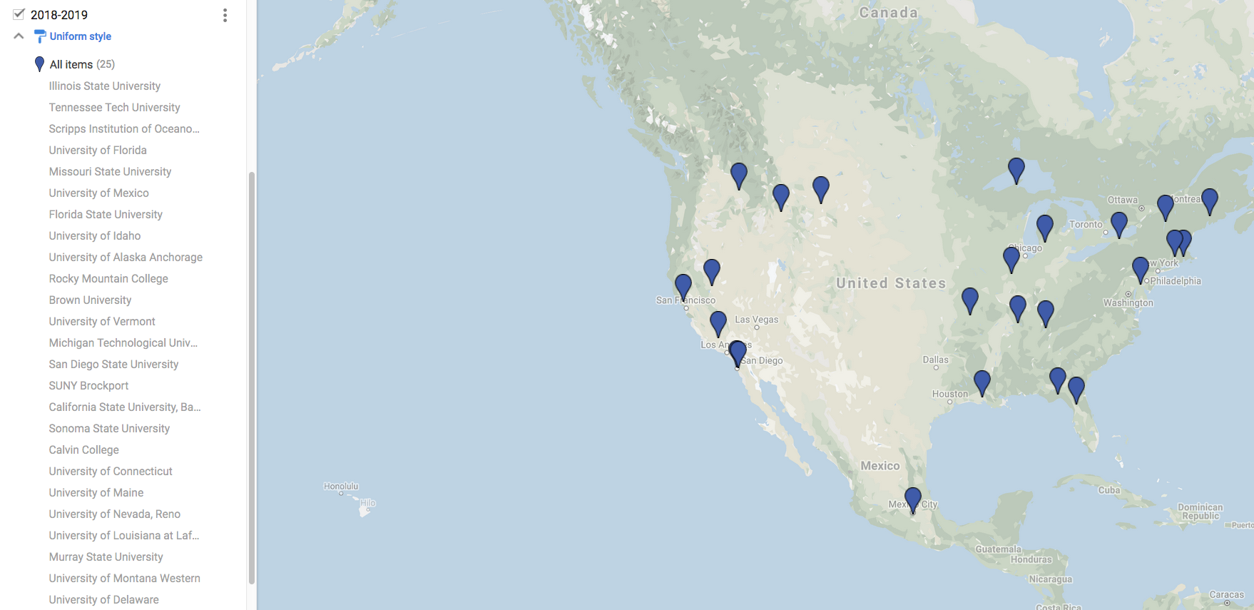
| Date | Institution | Speaker |
|---|---|---|
| 09/28/18 | Illinois State University | Melissa Driskell |
| 10/08/18 | Tennessee Technical University | Melissa Driskell |
| 11/02/18 | Scripps Institution of Oceanography | Chris Marone |
| 11/08/18 | University of Florida | Melissa Driskell |
| 11/08/18 | University of Delaware | Colleen Dalton |
| 11/16/18 | Missouri State University | Chris Marone |
| 12/04/18 | National Autonomous University of Mexico | Chris Marone |
| 01/18/19 | Florida State University | Colleen Dalton |
| 01/24/19 | University of Idaho | Diego Melgar |
| 01/24/19 | University of Alaska Anchorage | Basil Tikoff |
| 01/29/19 | Rocky Mountain College | Basil Tikoff |
| 01/31/19 | Brown University | Basil Tikoff |
| 02/04/19 | Michigan Technical University | Diego Melgar |
| 02/06/19 | San Diego State University | Diego Melgar |
| 02/12/19 | SUNY Brockport | Basil Tikoff |
| 02/14/19 | California State University, Bakersfield | Basil Tikoff |
| 02/20/19 | Sonoma State University | Diego Melgar |
| 03/08/19 | University of Connecticut | Colleen Dalton |
| 03/15/19 | University of Maine | Melissa Driskell |
| 03/25/19 | University of Nevada Reno | Chris Marone |
| 03/29/19 | University of Louisiana Lafayette | Colleen Dalton |
| 03/29/19 | Calvin College | Diego Melgar |
| 04/19/19 | Murray State University | Colleen Dalton |
| 04/29/19 | University of Montana Western | Melissa Driskell |
| 04/29/19 | University of Vermont | Chris Marone |
| 05/09/19 | University of Delaware | Colleen Dalton |
Previous Speakers
EarthScope speakers are selected based on their outstanding research accomplishments involving EarthScope as well as their abilities to engage a variety of audiences. Each speaker presents science-based lectures on their own EarthScope-related project, and their talks include an introduction highlighting broader EarthScope objectives and accomplishments.
Dr. Julie Elliott: Associate Professor, Department of Earth, Atmospheric and Planetary Science | Purdue University
 Julie Elliott is an Assistant Professor in the Earth, Atmospheric, and Planetary Sciences Department at Purdue University. Her research focuses on using GPS and imaging geodesy to examine tectonic phenomena including long-term plate motions, the distribution of relative motion within plate boundary zones, earthquakes, and transient tectonic deformation as well as non-tectonic signals such as glacial isostatic adjustment and glacier dynamics. She received a BA in Physics from Whitman College, an MS and a PhD in Geophysics from the University of Alaska Fairbanks, and was a postdoc at Cornell University. Julie is PI of an ongoing EarthScope project using GPS to look at fault locking and possible transient tectonic signals along the eastern edge of the Alaska subduction zone.
Presentation: Active Deformation in Alaska and Western Canada Observed with GPS
GPS has revolutionized our understanding of how tectonic plates interact. As networks of GPS sites have become denser, the idea that relative plate motion is accommodated along discrete, narrow boundaries has given way to a more complex picture of broad plate boundary zones and distributed deformation that may stretch 100’s of kilometers beyond the major boundary fault systems. Continuously operating GPS sites, such as those in the Earthscope Plate Boundary Observatory (PBO), have allowed us to reduce measurement uncertainty and capture transient events such as slow slip episodes, postseismic motion, and seasonal variations, providing a more complete image of the deformation field.
This talk will discuss what data from PBO and other regional GPS networks tells us about crustal deformation in Alaska and western Canada. The deformation field here is complex, with contributions from long-term tectonic motion, earthquakes, postseismic deformation, slow slip episodes, seasonal snow loading, and the adjustment of the Earth to current and past ice loss. Tectonic models constrained by the long-term motion reveal a wide and heterogeneous plate boundary zone, a sharp contrast to textbook descriptions of the interaction between the Pacific and North American plates. While there are major fault systems, such as the Fairweather-Queen Charlotte transform and the Aleutian megathrust, where most of the motion occurs along a main structure, there are also instances of relative plate motion being partitioned across multiple faults. Some areas appear to behave as rigid, rotating blocks while other areas are more aptly described as zones of distributed deformation. Although the main boundary zone is near the coast, strain is transferred 100’s of kilometers inland into Canada and Alaska as well as outboard into the Pacific plate.
Dr. Karen Fischer: Professor of Earth, Environmental and Planetary Sciences | Brown University
 Karen is a seismologist at Brown University. Her research focuses on using seismic waves to constrain the structure of the mantle and crust to better understand dynamic processes inside the Earth. Her work includes field deployments of broadband seismometers, most recently SESAME, an EarthScope Flexible Array experiment in the southern Appalachians. Karen joined the faculty at Brown in 1990, following a B.S. in Geology and Geophysics from Yale University, a Ph.D. in Geophysics from the Massachusetts Institute of Technology, and a Lamont-Doherty Earth Observatory Postdoctoral Fellowship at Columbia University. Karen is a Fellow of the American Geophysical Union (AGU) and was the 2016 AGU Beno Gutenberg Lecturer. She has served as President of the AGU Seismology Section. At Brown Karen enjoys teaching courses that range from introductory physical geology to graduate level seismology.
Presentation: What puts the “plate” in plate tectonics?
The paradigm of plate tectonics is fundamental to our understanding of the Earth, yet the question of what makes the lithosphere “plate-like” remains unanswered. As Earth’s outer thermal boundary layer, the lithosphere derives its high viscosity largely from its cold temperatures, relative to the warmer asthenosphere. However, the roles of partial melt and volatiles in further reducing asthenospheric viscosity are still debated. Seismic wave conversions generated by a velocity gradient within the lithosphere-asthenosphere transition, combined with surface wave tomography, provide key constraints on these questions.
Data from the EarthScope USArray has enabled imaging of the lithosphere-asthenosphere boundary (LAB) and discontinuities internal to the lithosphere across the contiguous U.S. Strong S-to-P (Sp) conversions from the base of the thin lithosphere in the tectonically active western U.S. indicate a vertically-localized negative velocity gradient (<20-30 km) that is consistent with ponded partial melt, embedded in a broader thermal gradient. In contrast, beneath the thick, stable and ancient cratonic lithosphere in the center of the continent, the typical absence of clear Sp conversions is consistent with a gradual shear velocity decrease over >100 km; patches with a sharper gradient are spatially intermittent. The very gradual cratonic lithosphere-asthenosphere boundary can be explained by temperature without the effects of higher volatile content or partial melt in the asthenosphere. Middle-aged lithosphere in the eastern U.S., largely undisturbed since Mesozoic rifting, manifests an LAB velocity gradient of intermediate sharpness, except for a few zones that correlate with low mantle velocities and the possible presence of partial melt. Across active plate boundaries, variations in the depth and amplitude of the LAB velocity gradient across rifts and strike-slip fault systems indicate localized deformation in the deep mantle lithosphere. Within the cratonic mantle lithosphere, the most widespread feature is a sub-horizontal negative velocity gradient, typically at depths of 70-90 km, that can be explained by volatile-rich products of now-solid partial melt that once ponded beneath the carbonated peridotite solidus.
Dr. Rebecca Flowers: Associate Professor, Department of Geological Sciences | University of Colorado Boulder
 Rebecca Flowers is an Associate Professor in the Department of Geological Sciences at the University of Colorado Boulder. Her research is broadly on problems in continental tectonics, with a particular focus on better understanding the coupling of deeper Earth and surface processes. Flowers directs a (U-Th)/He geochronology lab. She and her group have used (U-Th)/He dating to address questions that include the carving of the Grand Canyon, the burial and erosion history of cratonic interiors, the uplift history of the Rocky Mountains and southern African Plateau, and the impact history of the moon. Her lab also is engaged in a variety of method development efforts on mineral phases not conventionally dated by (U-Th)/He, including perovskite, conodonts, baddeleyite, monazite, garnet, and rutile. Flowers received her BSc degree at the College of William & Mary, her MSc degree at the University of Utah, her PhD at MIT, and spent two years as a postdoctoral scholar at Caltech. She has served on the EarthScope Steering Committee, the AGU Tectonophysics Program Committee, the GSA Student Research Grant review committee, the Board of the GSA Structural Geology & Tectonics Division, and as an instructor at the CIDER (Cooperative Institute for Dynamic Earth Research) Summer Program. Flowers is the lead PI and organizer of the AGeS (Awards for Geochronology Student research) program, which was implemented within the EarthScope program as a new strategy for supporting community access to geochronology data and the scientific expertise of lab personnel.
Presentation: Deep-time hypsometric history of the North American continental interior and implications for mantle dynamics
Cryptic epeirogenic elevation change in continental interiors is not easily accounted for by plate margin tectonism. Dynamic topography, or elevation change of the Earth’s surface in response to normal traction generated by mantle convection, provides an attractive explanation for such vertical motions. However, despite the increasing sophistication of dynamic modeling efforts, it remains challenging to definitively test the predictions of these models. The North American continental interior was shielded from distal tectonism during the Phanerozoic, making this region an excellent location to isolate the effects of dynamic topography in the rock record. In this talk I will outline our interdisciplinary strategy to decipher the thickness, spatial extent, and evolution of missing sections of the Phanerozoic stratigraphic record across the North American interior to illuminate the cryptic hypsometric evolution of the North American continent and how dynamic topography may have influenced this history. I will specifically focus on the implications of our results for 1) the potential significance of more substantial post-100 Ma burial across the central U.S. than previously recognized, and 2) the Paleozoic-Mesozoic burial, erosion, and vertical motion history across the North American interior and its possible dynamic cause.
Dr. Beth Pratt-Sitaula: Research Associate, Department of Geological Sciences | Central Washington University
Education and Community Engagement - Education Specialist | UNAVCO
 Beth has a dual background in tectonic geomorphology and geoscience education, with a special interest in geohazards learning. As a faculty member and research associate at Central Washington University, she has been a principal investigator on two EarthScope-funded education projects that brought cutting edge EarthScope science and preparedness to Pacific Northwest educators through professional development workshops. She also works as an Educational Specialist for UNAVCO, a non-profit consortium that runs NSF’s Geodetic Facility, including EarthScope’s Plate Boundary Observatory. At UNAVCO she manages the undergraduate education initiative including curriculum and faculty development featuring geodesy data and methods applied to critical societal issues. During the summers she runs a geoscience field camp in Nepal and teaches basic geology field skills and geohazard analysis to undergraduate students.
Presentation: EarthScope science as a springboard for disaster preparedness and science literacy
Engaging educators and students in complex EarthScope science may seem like a daunting task, but several EarthScope projects have done this very successfully and can serve as models for others interested in education and broader impacts related to geohazards and societal challenges. Cascadia EarthScope Earthquake and Tsunami Education Program (CEETEP) ran a series of professional development workshops for K-12 teachers, park/museum interpreters, and emergency management educators from coastal Cascadia. Working together in action teams, these educators learned about earthquake, tsunami, and EarthScope science and preparedness and how to teach them effectively. The project was highly successful at increasing educator geoscience content knowledge, teaching confidence, preparedness actions, and community optimism and involvement. CEETEP built on previous successful EarthScope projects: Teachers on the Leading Edge and EarthScope Interpretative Workshops, which ran professional development programs for middle school teachers and informal educators, respectively. In the realm of undergraduate learning, the GEodesy Tools for Societal Issues (GETSI) project provides curricular resources for teaching with geodesy data and methods within a context of societal challenges. GPS and lidar data from EarthScope’s Plate Boundary Observatory are used in several modules on topics from earthquake and landslide hazards to water resource assessment. With GETSI’s well-designed modules, undergraduate students consistently meet the module learning goals and faculty participants in dissemination workshops report confidence and motivation to teach with these complex and cutting edge data sets. This presentation will provide many more details about these effective teaching resources and methods that will enable a range of instructors and students to use them.
Dr. Carl Tape: Associate Professor, Geophysical Institute | University of Alaska Fairbanks
 Carl Tape is a seismologist the University of Alaska Fairbanks. He develops and applies techniques in computational and observational seismology to obtain better images of Earth's internal structure and to obtain better representations of earthquakes. Three-dimensional numerical simulations of the seismic wavefield form the foundation of computational seismology. These simulations produce synthetic seismograms and also volumetric sensitivities that are used within the seismic imaging problem. Improved seismic images of the crust and mantle provide an important snapshot of a dynamic Earth, and they can be used for scenario earthquake simulations that help assess seismic hazard in earthquake-prone regions. Dr. Tape received his B.A. in physics and geology from Carleton College, a M.S. from Oxford University, and a Ph.D. from California Institute of Technology. He did postdoctoral research at Harvard University before starting as faculty at UAF in 2010.
Presentation: Seismology in Alaska: earthquakes, bears, and high-performance computing
Alaska is one of the world's prolific producers of earthquakes, including the 2002 magnitude 7.9 strike-slip earthquake on the Denali fault and the 1964 magnitude 9.2 subduction earthquake on the Alaskan megathrust. Earthquakes occur throughout the state and are a reminder of the active subduction, collision, and faulting that have shaped the highest mountains in North America. Over the past five years, seismic stations have been deployed in some of Alaska's most inaccessible regions. New seismic data provide opportunities to characterize new fault zones and to image complex subsurface structures, from the underlying Pacific slab to sedimentary basins within the crust. Complex structures produce complex earthquake ground motion that can be modeled using high-performance computational resources. I will discuss new seismic deployments, discoveries, and scientific frontiers in Alaska.
Dr. William Hammond: Research Professor at Nevada Bureau of Mines and Geology, Nevada Seismological Laboratory | University of Nevada
_0.jpg) Bill is a Professor of Geodesy and Geophysics who does research using space geodetic techniques such as GPS and InSAR to study tectonic deformation of the continents, mountain building processes, active faults, dynamics of the lithosphere and structural controls on geothermal systems. Bill has wrestled for a long time over a fascination with how the deep solid Earth controls the development of the landscape we live on. He has spent a lot of time poking around the Intermountain West collecting GPS data and taking inspiration from this landscape. Bill now does research, teaches and advises graduate students in the Nevada Geodetic Laboratory that is a part of the Nevada Bureau of Mines and Geology at the University of Nevada, Reno. He also manages the MAGNET GPS network, which includes over 400 stations in 5 western states. He got his B.A in mathematics at UC Berkeley, Ph.D. at the University of Oregon, followed by a post-doctoral position at the USGS in Menlo Park, CA. He has been a professor at UNR since 2004. When not working at the University, Bill spends time with his wife and three children in the Sierra Nevada town of Truckee California, where they enjoy the skiing, cycling, swimming and outdoor activities of all kinds.(See More)
Bill is a Professor of Geodesy and Geophysics who does research using space geodetic techniques such as GPS and InSAR to study tectonic deformation of the continents, mountain building processes, active faults, dynamics of the lithosphere and structural controls on geothermal systems. Bill has wrestled for a long time over a fascination with how the deep solid Earth controls the development of the landscape we live on. He has spent a lot of time poking around the Intermountain West collecting GPS data and taking inspiration from this landscape. Bill now does research, teaches and advises graduate students in the Nevada Geodetic Laboratory that is a part of the Nevada Bureau of Mines and Geology at the University of Nevada, Reno. He also manages the MAGNET GPS network, which includes over 400 stations in 5 western states. He got his B.A in mathematics at UC Berkeley, Ph.D. at the University of Oregon, followed by a post-doctoral position at the USGS in Menlo Park, CA. He has been a professor at UNR since 2004. When not working at the University, Bill spends time with his wife and three children in the Sierra Nevada town of Truckee California, where they enjoy the skiing, cycling, swimming and outdoor activities of all kinds.(See More)
Presentation: GPS Imaging of Earth’s Vertical Motion: From Sierra Nevada to North America
Vertical land motion attributable to deep solid Earth processes has some of the most profound impacts on Earth’s topography, but its geodetic signals are elusive and among the most difficult to observe directly. In this presentation I will show how we are using a new data visualization technique ‘GPS Imaging’ to enhance the interpretation of vertical motions. Like a doctor’s x-ray of the Earth, reminiscent of seismic tomography, the images show snapshots of the dynamic response to various events and loads from past and present large scale geophysical events. The images reveal in detail the effects of present day shallow mantle flow and flexure of the lithosphere associated with processes such as uplift of the Sierra Nevada, hydrological loading of the lithosphere, glacial isostatic adjustment, interseismic strain and post-earthquake relaxation. GPS Imaging focuses attention on the component of uplift that is driven by these large-scale geodynamic effects, providing a new window to view mantle processes. Creating these images is possible by development of GPS networks which are undergoing exponential proliferation across the planet, increasing coverage, lengthening time series, and transforming our view of Earth’s shape and how it changes over time. Advances in data processing have made it possible to cope with this new torrent of data. At the Nevada Geodetic Laboratory we now process data from over 14,400 stations globally distributed, and together with UNAVCO are now promoting the Plug and Play GPS concept to make the data products more accessible, discoverable, and useful for all. Our system now presents a portal through which it is possible to view ongoing Earth deformation with unprecedented scope and ease. The presentation will include a short introduction to the Plug and Play GPS data products.
Dr. Maureen Long: Assistant Professor of Geology and Geophysics | Yale University
_0.jpg) Maureen Long is an Associate Professor of Geology and Geophysics at Yale University. Her interests lie in the areas of observational seismology and mantle dynamics, with a focus on subduction zone dynamics and processes, the structure and evolution of continental lithosphere, and the dynamics of the lowermost mantle. She received her B.S. degree in geology from Rensselaer Polytechnic Institute and her Ph.D. in geophysics from the Massachusetts Institute of Technology. Maureen spent two years as a postdoctoral fellow at the Department of Terrestrial Magnetism of the Carnegie Institution for Science before moving to Yale in 2009. She has served on the USArray Advisory Committee, the Electromagnetic Working Group, the GeoPRISMS Steering and Oversight Committee, and the EarthScope National Meeting Organizing Committee.(See More)
Maureen Long is an Associate Professor of Geology and Geophysics at Yale University. Her interests lie in the areas of observational seismology and mantle dynamics, with a focus on subduction zone dynamics and processes, the structure and evolution of continental lithosphere, and the dynamics of the lowermost mantle. She received her B.S. degree in geology from Rensselaer Polytechnic Institute and her Ph.D. in geophysics from the Massachusetts Institute of Technology. Maureen spent two years as a postdoctoral fellow at the Department of Terrestrial Magnetism of the Carnegie Institution for Science before moving to Yale in 2009. She has served on the USArray Advisory Committee, the Electromagnetic Working Group, the GeoPRISMS Steering and Oversight Committee, and the EarthScope National Meeting Organizing Committee.(See More)
Presentation: The Appalachians and how they got that way: Structure and dynamics of eastern North America
The surface geology of eastern North America is extraordinary in its complexity. This complexity reflects a wide range of tectonic processes that have operated in the region over the past billion years, including episodes of subduction and rifting associated with two complete Wilson cycles of supercontinent assembly and breakup. However, it is unknown how the deep crust and mantle lithosphere have responded to these tectonic forces over time; furthermore, the persistence of Appalachian topography through time remains a major outstanding problem in the study of landscape evolution.
The deployment of the EarthScope USArray in eastern North America is opening up new frontiers in the study of the deep structure and dynamics of the crust, mantle lithosphere, and asthenospheric mantle beneath this passive continental margin. In this talk I will discuss recent results from the EarthScope project on the structure of the crust and upper mantle beneath eastern North America. These include new results from the MAGIC project, a multidisciplinary collaboration that includes a USArray Flexible Array deployment across the Appalachians in Virginia, West Virginia, and Ohio. In particular, new constraints on seismic anisotropy (that is, the directional dependence of seismic wavespeeds) beneath eastern North America are yielding new understanding of the deformation of the crust and mantle lithosphere during past tectonic episodes, as well as the pattern of mantle flow beneath the present-day passive margin and its possible effects on surface topography.
Dr. Diane Moore: Earthquake Science Center | USGS Menlo Park, CA
_0.jpg) Diane Moore is a geologist with a background in metamorphic petrology who works in the rock deformation laboratory at the U. S. Geological Survey (USGS) in Menlo Park, CA. Her research deals with the frictional behavior of fault-zone materials at elevated temperatures and pressures. In recent years, she has focused on the frictional properties of sheet-silicate minerals, with an emphasis on the Mg-rich phyllosilicates associated with ultramafic rocks. She has had considerable involvement with the San Andreas Fault Observatory at Depth (SAFOD) deep-drilling program, and has conducted both petrologic and rock-mechanics investigations of the SAFOD core. Diane received a B.S. in geology from the University of Illinois and a Ph.D. in geology from Stanford University. She first came to the USGS as a National Research Council post-doctoral fellow and since then has been a research scientist in the Earthquake Hazards Program.(See More)
Diane Moore is a geologist with a background in metamorphic petrology who works in the rock deformation laboratory at the U. S. Geological Survey (USGS) in Menlo Park, CA. Her research deals with the frictional behavior of fault-zone materials at elevated temperatures and pressures. In recent years, she has focused on the frictional properties of sheet-silicate minerals, with an emphasis on the Mg-rich phyllosilicates associated with ultramafic rocks. She has had considerable involvement with the San Andreas Fault Observatory at Depth (SAFOD) deep-drilling program, and has conducted both petrologic and rock-mechanics investigations of the SAFOD core. Diane received a B.S. in geology from the University of Illinois and a Ph.D. in geology from Stanford University. She first came to the USGS as a National Research Council post-doctoral fellow and since then has been a research scientist in the Earthquake Hazards Program.(See More)
Presentation: The role of serpentinite in promoting creep in the San Andreas Fault System of central and northern California
Core recovered from two actively creeping strands of the San Andreas Fault (SAF) at ~2.7 km depth in the San Andreas Fault Observatory at Depth (SAFOD) borehole is rich in serpentinite and its low-T alteration products, Mg-rich smectite clays. The core provided the first direct evidence supporting the long-held view that serpentinite is implicated in the origin of creep. Using the core samples as a guide, similar serpentinite-rich fault gouge has now been identified in outcrops of the SAF near the drill site and, recently, in a creeping strand of the Bartlett Springs Fault (BSF) in northern California. For both the central SAF and BSF occurrences, the serpentinite is confined to the ~1-3- m-wide shear zones where creep is localized, and it is sandwiched between quartzofeldspathic wall rocks. My talk will focus on how shear-enhanced reactions between the ultramafic serpentinite and the quartzose crustal rocks can promote fault creep at otherwise seismogenic depths. I will first describe the mineralogy, textures, and alteration features of the serpentinite-bearing fault gouge samples. I will then review a series of friction experiments at hydrothermal conditions in which serpentinite gouge sheared between quartz-bearing rocks weakens and slides stably, in contrast to the relatively strong and potentially unstable behavior of serpentinite in an ultramafic chemical setting. The Mg-phyllosilicate alteration products of serpentinite (e.g., saponite, talc, chlorite) are also weak and stably sliding over their P-T stability ranges. Finally, I will correlate the geographic distribution of creeping faults in northern California with tectonic models of the occurrence of the Coast Range ophiolite at depth, and discuss the mode(s) of emplacement of serpentinite into those faults.
Dr. Steve Semken: Associate Professor Associate Director of Community Outreach, Senior Sustainability Scientist
School of Earth and Space Exploration | Arizona State University
_0.jpg) Steven Semken is an ethnogeologist and geoscience education researcher who works at the intersection of geology, geography, ethnography, and learning sciences. He and his students explore the influences of place, culture, and affect on modes of teaching and inquiry in the Earth sciences. Much of their research focuses on geologically and culturally diverse regions of the Southwest U. S. and Latin America, and especially their Native American and Hispanic/Latino communities. They also work with interpretive professionals and the public at several U. S. and foreign National Parks. The goal of his group is to apply research-tested, place-based and culturally infused teaching methods to foster public Earth science literacy, greater diversity in the geoscience community, and environmental and cultural sustainability in their study regions. Semken received his SB in geology and PhD in materials science from the Massachusetts Institute of Technology and his MS in geochemistry from the University of California, Los Angeles, and taught at the Diné (Navajo) Tribal College before joining the ASU faculty in 2003. He is a former Associate Director of the EarthScope National Office, a Past-President and former Distinguished Speaker of the National Association of Geoscience Teachers, and a Fellow of the Geological Society of America. Semken has received the highest awards for teaching at ASU, Diné College, and MIT. He is most interested in assisting educators, students, and the public to leverage their personal and cultural connections to places and landscapes in order to improve geoscience literacy for all.(See More)
Steven Semken is an ethnogeologist and geoscience education researcher who works at the intersection of geology, geography, ethnography, and learning sciences. He and his students explore the influences of place, culture, and affect on modes of teaching and inquiry in the Earth sciences. Much of their research focuses on geologically and culturally diverse regions of the Southwest U. S. and Latin America, and especially their Native American and Hispanic/Latino communities. They also work with interpretive professionals and the public at several U. S. and foreign National Parks. The goal of his group is to apply research-tested, place-based and culturally infused teaching methods to foster public Earth science literacy, greater diversity in the geoscience community, and environmental and cultural sustainability in their study regions. Semken received his SB in geology and PhD in materials science from the Massachusetts Institute of Technology and his MS in geochemistry from the University of California, Los Angeles, and taught at the Diné (Navajo) Tribal College before joining the ASU faculty in 2003. He is a former Associate Director of the EarthScope National Office, a Past-President and former Distinguished Speaker of the National Association of Geoscience Teachers, and a Fellow of the Geological Society of America. Semken has received the highest awards for teaching at ASU, Diné College, and MIT. He is most interested in assisting educators, students, and the public to leverage their personal and cultural connections to places and landscapes in order to improve geoscience literacy for all.(See More)
Presentation: EarthScope Education and Outreach: Transcontinental, yet Place-Based
All regions of the United States have interesting and instructive geodynamic and geomorphic histories, but many also have limited exposures: a challenge to locally based Earth science teaching. The unprecedented detail about transcontinental crustal and mantle structure and dynamics now revealed by the EarthScope Program can help bring local geologic stories to life for teachers and students, and help foster place-based (PB) teaching: a method that situates both content and practice in the landscapes and communities of specific, typically local, places and regions. PB teaching is applicable to classroom, lab, and field instruction and to free-choice teaching (interpretation) practiced in parks and museums. PB geoscience learners construct knowledge by engaging with accessible and familiar Earth features, processes, and history; and exploring geoscientific controls on local and regional environmental and sociocultural sustainability and public safety. Education research increasingly supports the use of PB teaching to motivate interest and foster scientific literacy in more diverse learners (including underrepresented minority students) as well as the general public. EarthScope researchers and educators from Virginia to Alaska are themselves developing and disseminating resources and programs intended to share locally relevant geoscientific findings with educators and the public, and many illustrative examples are now available to apply or use as templates for PB geoscience teaching. This presentation draws on a range of projects, resources, and evaluations for PB education and outreach conducted nationwide by the EarthScope Program, but it can be tailored to accommodate the place- or region-specific interests of host institutions in infusing EarthScope science and PB teaching methods into their own programs in geoscience education, interpretation, public outreach, or K-12 teacher or interpreter professional development in the Earth sciences.
Dr. Amanda Thomas: Assistant Professor, Department of Geological Sciences | University of Oregon
 Amanda Thomas is a seismologist at University of Oregon where she's been an assistant professor since 2015. Her work focuses on better understanding slow slip processes, deep fault rheology, and fault friction. Amanda graduated from the Georgia Institute of Technology with a B.S. in Civil Engineering in 2007. She received her PhD in 2012 from the University of California, Berkeley while working under the supervision of Prof. Roland Burgmann on slow earthquakes and fault rheology. She was an NSF Postdoctoral Fellow at Stanford University working with Greg Beroza and David Shelly on the low-frequency earthquake source. Her ongoing projects include using models of fault friction to understand secondary slip fronts that occur during slow slip events, estimating strong ground motion in Cascadia, and using Nodal seismometers to better understand the seismic source and site response.(See More)
Presentation: Low-Frequency Earthquakes
Low-frequency earthquakes (LFEs) are small repeating earthquakes that occur in conjunction with deep slow slip. Like typical earthquakes LFEs are thought to represent shear slip on crustal faults but when compared to earthquakes of the same magnitude LFEs have lower corner frequencies, implying longer durations, and are depleted in high-frequency content relative to earthquakes of similar magnitude. Along the San Andreas Fault, and in the Cascadia subduction zone, LFEs occur in rapid succession, forming tectonic tremor. Here we present results from LFE source studies in both Parkfield and Cascadia. In Parkfield, we use an empirical Green’s function approach to investigate which physical properties of the LFE source cause high-frequency depletion. We find that the M~1 LFEs have typical durations of ~0.2 s. Using the annual slip rate of the deep SAF and the average number of LFEs per year we estimate average LFE slip rates of ~0.24 mm/s. When combined with the LFE magnitude this number implies a stress drop of ~104 Pa, two to three orders of magnitude lower than ordinary earthquakes, and a rupture velocity of order 0.35 km/s, 10% of the shear wave speed. Typical earthquakes are thought to have rupture velocities of ~80-90% the shear wave speed. In Cascadia, we correct LFE waveforms for path effects and use the resulting source time functions to calculate LFE duration and magnitude. We use these estimates to show that, like Parkfield, LFEs in Cascadia also have low stress drops, rupture and slip velocities. We also find that LFE duration displays a weaker dependence upon moment than expected for self-similarity, suggesting that LFE asperities are limited in dimension and that moment variation is dominated by slip. This behavior implies that LFEs exhibit a scaling distinct from both large-scale slow earthquakes and regular seismicity. Together the slow rupture velocity, low stress drops, and slow slip velocity explain why LFEs are depleted in high frequency content relative to ordinary earthquakes and suggest that LFE asperities represent areas capable of relatively higher slip speed in deep fault zones. Additionally, changes in rheology may not be required to explain both LFEs and slow slip; the same process that governs the slip speed during slow earthquakes may also limit the rupture velocity of LFEs.
Dr. Heather DeShon - Associate Professor Huffington Dept. of Earth Sciences | Southern Methodist University
 Dr. Heather DeShon is a seismologist at Southern Methodist University whose research focuses on understanding earthquake initiation and rupture complexity. She uses high-resolution earthquake relocation and tomography to explore the spatial and temporal relationships between seismic source characteristics and structural variability. Her background in using local amphibious seismic networks to understand subduction seismogenic zone processes has more recently been applied to studies of intraplate seismicity and lithospheric structure in the central US. More broadly, her research interests are aimed at improving the characterization of seismic and tsunami hazard. Heather received her B.S. in Geophysics and Mathematics at Southern Methodist University and a Ph.D. in Earth Sciences (Geophysics) from the University of California-Santa Cruz. (See More)
Presentation: Death of a Fault: A Comparison of Seismicity in the New Madrid Seismic Zone and North Texas
Increased seismicity rates across the central United States have raised scientific questions and local and national concerns about the impact of shale gas production on infrastructure and subsurface structures such as faults. But the central US is not historically aseismic and intraplate faulting is not uncommon. This talk explores similarities and differences between the intraplate New Madrid seismic zone, host to the large (M7+) earthquakes of 1811-1812 and focus of the Earthscope NELE experiment, and ongoing earthquake sequences occurring in the Fort Worth (Barnett Shale) Basin. Both New Madrid seismicity and North Texas earthquakes occur along reactivated ancient faults located in the basement granites and overlying sedimentary units and release natural tectonic stresses. New Madrid has a long paleoseismic record of large earthquakes. In contrast, North Texas had no credible felt earthquakes prior to 2008 and the recent swarms have been linked to local wastewater injection associated with shale gas extraction (2008/2009 DFW; 2009 Cleburne; 2013 Azle); studies of the 2014/2015 Irving-Dallas and 2015 Venus sequences are ongoing. Both regions are currently monitored – New Madrid by the USGS and CERI permanent network and Earthscope stations and North Texas by a ~40 station temporary network operated by SMU with support from the USGS. High-resolution earthquake locations, waveform correlation, and source characteristics are combined with information on subsurface geology and fault structure, and 3D pore pressure modeling to provide insight into the relationship between fluid migration at depth and modern microseismicity along pre-existing fault structures. Understanding if and/or how injection of fluids into the crystalline crust reactivates faults have important implications for seismology (i.e., fault physics), the energy industry, and society. Comparisons of potentially induced sequences like North Texas with natural intraplate seismic zones like New Madrid may yield important insights to understanding the long-term hazard associated with the increased seismicity in the Central US.
Dr. Adrian Borsa - Assistant Researcher Institute of Geophysics and Planetary Physics | Scripps Institution of Oceanography
 Adrian Borsa is a researcher at the Institute of Geophysics and Planetary Physics at the Scripps Institution of Oceanography. His work aims to describe how the shape of Earth's surface is changing at timescales of seconds to decades, and to link observed change to geophysical processes associated with phenomena ranging from earthquakes to climate change. Dr. Borsa's expertise includes the collection and analysis of geodetic data from many sources, including permanent and mobile GPS sensors, airborne lidar, and satellite altimeters. He is also actively involved in the calibration and validation of elevation measurements from several generations of satellite altimeters, and has made the remote salar de Uyuni in Bolivia his field home for the past decade in support of this work. Dr. Borsa took an atypical route to science, beginning with a B.A. in Government, an M.A. in International Relations, and an early career in international business focused on Japan and the United States. He received his PhD from the Scripps Institution of Oceanography in 2005, was posted at the US Geological Survey during his post-doc, and moved to Boulder, CO to take a management position within NSF's EarthScope program. He returned to Scripps and to full-time scientific research in 2012. (See More)
Presentation: What EarthScope's Plate Boundary Observatory can tell us about water resources in the western United State
Following a year of above-average precipitation in 2011, the western United States entered into drought in late 2012 and has yet to emerge. The severity of the current drought is focusing public attention on known water resource challenges in the West and is changing assumptions about how water use should be monitored and regulated. Despite this new interest in water management, snowpack and groundwater — key components of water storage — are sparsely instrumented and cannot yet be adequately monitored from space. As a result, a new paradigm is emerging for observing water in the western US. Because the solid earth responds elastically to hydrological loading, changes in water storage can be inferred from surface displacements measured using the Global Positioning System (GPS). EarthScope¹s Plate Boundary Observatory includes a continuous GPS network that has proved to be an exceptional tool for monitoring the spatiotemporal evolution of the hydrological cycle. Seasonal changes in water loading have long been known to drive annual cycles of GPS site motion, but changes over both longer and shorter periods are detectable and yield insights into weather and climate phenomena from individual storms to multiyear drought. Scientific GPS networks such as the Plate Boundary Observatory, originally built to study crustal displacement from plate tectonics and volcanic processes, could soon become an important extension of the global hydrological observing system.
Dr. Fan-Chi Lin - Assistant Professor Geology and Geophysics | University of Utah
 Fan-Chi Lin is a seismologist at the University of Utah, where he has been an assistant professor in the Department of Geology and Geophysics since 2013. His main scientific interest is using seismic signals to improve our current understanding of the earth’s interior structure. The main focus of his research is developing innovative seismic interferometry and array processing techniques to extract new information that can be used to constrain the structure of the earth, from the surface to the core. After receiving his B.S. and M.A. in physics from National Tsing Hua University, Taiwan, and Drexel University, respectively, he obtained his Ph.D. in geophysics from the University of Colorado in 2009, where he worked under the supervision of Prof. Michael Ritzwoller on ambient noise and surface wave tomography. In 2011, he received a Director’s Post Doctoral Fellowship at the California Institute of Technology to continue his research on seismic interferometry and surface wave tomography with Prof. Victory Tsai and Robert Clayton. In 2015, he received the Charles F. Richter Early Career Award from the Seismological Society of America. His ongoing projects include imaging the Yellowstone magma plumbing system, fault zone structure, shallow crustal structure, and inner core structure using seismic interferometry and seismic tomography. (See More)
Presentation: Seismic Interferometry and Tomography Across USArray – Imaging Interior Earth Structure from Upper Crust to Inner Core
Over the last 10 years, the large-scale dense seismic network of EarthScope USArray Transportable Array has progressively been deployed with a ~70 km station spacing to cover the entire contiguous United States. The unprecedented amount of high quality broadband seismic data allows seismologists to image detailed earth structure on various different scales from shallow to deep. In particular, innovative seismic analyzing techniques have been developed to better utilize the array configuration and to extract new constraints on the structure of the earth that were not available before. In this presentation, I will first discuss some of the recent developments in seismic interferometry and tomography. I will explain how seismologists can now extract useful seismic signals from diffusive wavefields, such as the ambient noise wavefield and the earthquake coda wavefield. I will then demonstrate how these new developments combined with data from USArray improve our understanding of the lithospheric structure across the US, the Yellowstone magma plumbing system, and the earth’s inner core structure.
Dr. Melodie French - Research Associate Department of Geology | University of Maryland
 Melodie French is an NSF Earth Sciences Postdoctoral Fellow at the University of Maryland, College Park. She is interested in the mechanical and fluid transport properties of fault zones using methods from experimental rock deformation and structural geology with particular concern for constraining seismic hazards. Her work is focused on determining how mechanical properties, fluid flow, and rock fabric lead to diverse fault slip behavior. Ongoing projects include: creep and seismic slip mechanisms in fault rock recovered from 2.7 km depth during the San Andreas Fault Observatory at Depth (SAFOD), the controls of fluid pressure on shear deformation of subduction zone rocks at the conditions of episodic tremor and slip (ETS), and fluid-injection triggereed seismicity. Melodie received her B.A. in Physics with a minor in Geology from Oberlin College, an M.S. in Geology from the University of Wisconsin, Madison, and a Ph.D. in Geophysics from Texas A&M University. (See More)
Presentation: Creep and the potential for seismicity along the central segment of the San Andreas Fault
The central segment of the San Andreas Fault (SAF) currently accommodates displacement by a combination of aseismic creep and microseismicty. In the past, earthquakes on the adjacent locked segments of the SAF have arrested at the boundaries of the creeping segment, indicating that it is a barrier to rupture propagation. Although historically aseismic, we still do not know whether a sufficiently large rupture could initiate on a locked segment and propagate into and through the creeping segment of the SAF.
The San Andreas Fault Observatory at Depth (SAFOD) program recovered fault rock from two clay-rich gouge zones at 2.7 km depth along the creeping segment of the SAF, near its boundary with the southern locked segment. The Southwest Deforming Zone (SDZ) and Central Deforming Zone (CDZ) are cumulatively four meters thick and are believed to accommodate most of the plate boundary displacement at SAFOD. I present results from deformation experiments conducted on gouge from the CDZ at shear rates that range from in-situ creep to seismic slip. The strength of the gouge varies with shear rate and this strength variation reflects an evolution in deformation processes that is recorded in the microstructure of the sheared gouge. I will discuss how the mechanical and microstructural properties are critical to constraining the potential for seismic slip along the creeping segment of the SAF. Finally, I will discuss how results from the SAFOD community have revealed the long-term evolution and seismic cycles of creeping plate boundary faults.
Watch a video of her talk at Marshall University in November 2015
Dr. Reed Burgette - Assistant Professor Department of Geological Sciences | New Mexico State University
 Reed Burgette studies neotectonics on geodetic (years to decades) and geologic (thousands to hundreds of thousands of years) timescales. His research interests center around understanding how deformation is distributed spatially in plate boundary zones, and temporally through the seismic cycle associated with individual structures. For the shorter time scale, Reed uses historical leveling and tide gauge observations as well as GPS and satellite altimetry to measure vertical deformation rates. He uses high resolution observations of topography coupled with Quaternary dating methods to measure deformation rates averaged over multiple seismic cycles. Reed's group is working along the west coast of the U.S., in the Tien Shan mountains of central Asia, and locally in the Rio Grande Rift. He received a B.A. in Geology and Biology at Whitman College. Reed’s interests in seismic hazards and understanding how active faults work led to a Ph.D. at the University of Oregon. He then worked as post-doctoral researcher at the University of Tasmania, applying satellite geodesy to questions of crustal deformation, sea level rise, and Antarctic ice sheet mass balance. He joined the faculty of New Mexico State University in 2013. (See More)
Presentation: Ups and downs of the U.S. West Coast: Implications of eight decades of vertical deformation measurements for seismic hazards and sea level impacts
Along active plate boundaries, vertical deformation of the crust results from strain accumulation between major earthquakes. Observations of this vertical deformation are important to constrain where faults are currently locked and may slip in future earthquakes, particularly when integrated with horizontal deformation imaged by GPS. Additionally, the vertical motion of the land along the coast can either enhance or counteract the effects of the global process of sea level rise on a local basis. In this presentation, I will show how observations of relative sea level change made at tide gauges and repeated leveling surveys can be used to measure the pattern and rate of vertical deformation over timescales of several decades to over a century. I will also review satellite-based estimates of vertical deformation and sea level rise made over the past two decades to assess the level of agreement between techniques and examine changes in deformation rates over time. Tectonic deformation is the dominant signal along the Cascadia portion of the coast, and is consistent with along-strike variation in locking behavior on the plate interface. Rates of vertical motion are lower along the transform portion of the plate boundary and include anthropogenic effects, but there are significant tectonic signals, particularly in the western Transverse Ranges where the crust is shortening across reverse faults. I will highlight emerging insights and outstanding questions derived from the vertical deformation rate field for understanding hazards from earthquakes and coastal inundation related to sea level rise.
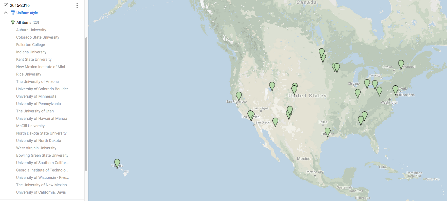
Dr. Anna Kelbert - Assistant Professor (Senior Research) in Geophysics | College of Earth, Ocean and Atmospheric Sciences, Oregon State University
 After getting her BA in Mathematics from Cambridge University, UK in 2002, Anna Kelbert got lured into geophysics by the promise of inverse problems: an exciting technique that provides a sneak peek into objects that cannot be directly measured or observed, such as the insides of the brain, or the insides of the Earth. She went on to devise a new method of imaging of the global electrical conductivity in the Earth¹s mantle, providing a useful additional constraint on mantle water content. These results formed the basis of her PhD in geophysics, obtained from Cardiff University, UK in 2006. At a mid-point of her PhD program, she followed her supervisor to Oregon State University, located in a beautiful small town of Corvallis, OR. Anna stayed there ever since, first as a postdoctoral researcher, then a Research Associate, and recently promoted to an Assistant Professor (Senior Research). Together with her colleagues at Oregon State University, she developed novel inversion codes in magnetotellurics, and employed these tools to image the partial melts and fluids beneath western United States with EarthScope MT data, a comprehensive data set comparable to the seismic Transportable Array, which Anna helped to quality control, process and archive. In the past few years, her continued research on global electrical conductivity of the Earth gave her new insights on the deep processes at subduction zone margins. Anna is also interested in cyberinfrastructure efforts aimed to improve knowledge integration and accessibility both within and across disciplines in geosciences. In her talk, Anna hopes to convey the value of electromagnetic methods in providing additional constraints on the deep Earth structure, particularly in complicated subduction settings. She is available for talks in fall and spring of 2014-2015, spring being preferable.(See More)
Presentation: Water Content and Processes in Complicated Subduction Settings as Inferred with Electromagnetic Methods
Natural source electromagnetic induction methods in geophysics include the local to regional scale magnetotelluric method, and the global to semi-global electromagnetics. Introduced in 1950-s, these methods have rapidly developed in the past 20 years to produce high resolution 3D images of the electrical conductivity in the Earth¹s crust and upper mantle. Electrical conductivity is most sensitive to the presence of fluids and partial melts, and therefore provides a view that¹s highly complementary to the seismic wave velocities. In this talk, I aim to introduce the methods through a tour of one of their most useful deep Earth applications: complicated subduction zone regions. I make use of the versatility of our techniques to look at subduction zones, globally, through the lens of electrical conductivity images; then zoom in to regional scales. I give an overview of electromagnetic constraints on the Philippine Sea plate subduction beneath China and Japan; the Nazca and Cocos plate subduction in South and Central Americas; and finally the younger subduction in North America, as imaged by EarthScope MT and the earlier studies. Throughout my brief global tour I try to show that electromagnetic inversion images the slabs and the associated volcanic arcs in a geophysically consistent manner that complements the seismic results, while adding independent and valuable information on the water content and the associated subduction-related processes.
Dr. Anne Egger- Assistant Professor Geological Sciences and Science Education | Central Washington University
 Anne Egger thought she might major in biology until she started running rivers on the Colorado Plateau, where she became far more interested in the rocks than in the vegetation. Her experience as a river guide has informed her teaching and research ever since. She received her undergraduate degree in geology from Yale University and her MS and PhD in geology from Stanford University, and is now an Assistant Professor at Central Washington University with a joint appointment in Geological Sciences and Science Education. This joint appointment reflects her research interests: her geologic research is focused on the tectonic development of the western margin of the Basin and Range province, and her geoscience education research is focused on developing curricular materials that incorporate societal issues, data, and geoscientific thinking. She has facilitated undergraduate curricular design at a variety of institutions, from reviving Stanford’s undergraduate geophysics program to reflect the diverse research interests of the faculty, to developing the first Earth science undergraduate degree in Singapore at Nanyang Technological University, to reforming the Middle-Level Science Teaching major at CWU to better meet the Next Generation Science Standards. She is particularly interested in emphasizing the connections between research and education at all levels: incorporating scientific research results into science classes, reforming teaching based on scientific results, and involving students in authentic scientific experiences. (See More)
Presentation: Integrating Teaching and Research with a 21st Century Toolbox
As geoscientists in the 21st century, we have an enormous variety of tools and vast datasets at our disposal. Worldwide imagery and high-resolution topography are widely available for free; real-time data are available on the web–much of it through EarthScope–for earthquakes, geodesy, atmospheric and oceanic parameters, and more; sophisticated computation is available through laptop computers. These tools and techniques serve our interests both in research and in teaching to reach a broad audience, from general education students to advanced geoscience majors. Through the InTeGrate project (NSF’s STEP Center in the Geosciences), we have developed a rubric-based process for developing curricular materials that teach geoscience in the context of grand challenges, develop interdisciplinary problem solving skills, make use of authentic geoscience data, develop geoscientific thinking skills, and develop systems thinking skills. These materials are supporting programmatic and institutional change to broaden access to the geosciences, strengthen the role of geoscience in teacher preparation and general education programs, and infuse geoscience content into other majors, such as economics, sociology, biology, and literature. This talk will draw from the results of the InTeGrate project, but can be tailored to the needs and interests of departments to focus strategies for incorporating active learning with EarthScope and other data into the geoscience curriculum, developing geoscientific thinking skills in all students, broader initiatives in STEM education and how geoscience fits in, among other possibilities.
Dr. David Schmidt - Associate Professor Department of Earth and Space Sciences | University of Washington
 David Schmidt uses geodetic tools to study the active deformation of the earth’s crust. His primary scientific interest is the study of fault processes along plate boundaries. He specializes in using InSAR data to study a variety of processes, including imaging shallow creep on active faults, the kinematics of slow moving landslides, glaciers, volcanic unrest, and land subsidence. His research group is actively studying slow slip and tremor on the Cascadia subduction zone. David is also currently involved in the development of an earthquake early warning system for the Pacific Northwest. For his undergraduate training, David attended the University of California, San Diego. He pursued his Ph.D. in Geophysics at the University of California, Berkeley, where he used InSAR to characterize deformation in the San Francisco Bay Area. Following a postdoc at Stanford University, David moved to the Pacific Northwest and served as a faculty member at the University of Oregon. He is currently an associate professor at the University of Washington. David has served on a number of committees, most recently the WInSAR Executive Committee, UNAVCO’s Education and Community Engagement Committee, as well as a term on a NSF panel. He is available for talks in the winter and spring of 2015.(See More)
Presentation: The Silent Life and Quivering Fits of the Cascadia Subduction Zone
The Cascadia subduction zone had long been thought to be aseismic given the lack of background seismicity. However, key observations over the past three decades have provided evidence of past large ruptures (up to Mw 9). Today we know that strain is accumulating on the plate interface, as revealed by observations of crustal deformation along the coast. However, the accumulation and release of strain is heterogeneous in space and time. Significant strain is stored over the duration of the earthquake cycle (100’s-of-years) and will eventually be released in the next megathrust event. Some strain is stored and released over short periods (months-to-years) in the form of slow slip and tremor.
In this presentation, I describe the range of interseismic deformational processes that occur along the plate interface on the Cascadia subduction zone as revealed by GPS, leveling, and tremor data. These data constrain the rate of strain accumulation and provide important constraints on the seismic hazard. The data also allow us to map out the pattern of long-term and transient locking associated with the silent accumulation of strain and the quivering fits of slow slip events. I will present new modeling results that describe the time-dependent distribution of locking and strain release along the plate boundary. The diverse, time-dependent faulting behavior suggests that fault properties and physical conditions are heterogeneous. I will review and hypothesize on which physical properties exert the greatest control on the faulting behavior as a function of depth along the plate interface. Finally, I will highlight the scientific questions that remain unanswered for Cascadia and the exciting opportunities for new research on the horizon.
Dr. Mark Simons - Professor of Geophysics | California Institute of Technology
 Mark Simons is a geophysicist interested in physics of the earthquake cycle, volcanic unrest, structure and dynamics of the upper mantle, glacier mechanics and the application of space geodesy to rapid disaster response. Mark’s earliest research was on multi-scale analysis of global gravity fields to understand upper mantle dynamics on Venus and the Earth. Subsequently, he shifted to problems in lithospheric dynamics, primarily with an emphasis on continued development of InSAR techniques and combination of GPS and InSAR observations to constrain deformation processes. Mark enjoys problems in inverse theory, particularly as applied to our understanding of fault slip in major plate boundary fault systems (e.g., Japan, California, Chile/Peru, and Turkey). He received his B.Sc. degree in geophysics from UCLA in 1989 and his Ph.D. in geophysics from M.I.T. in 1996. He started at Caltech as postdoc in 1996 and joined the faculty there in 1998. Mark has served on the PBO steering committee and the NASA Earth Science Subcommittee. He is currently on the science definition team for the upcoming U.S./India dedicated InSAR mission expected to launch this decade. (See More)
Presentation: Imaging geodesy of volcanoes, earthquakes, fault creep, glaciers and aquifers - opportunities and challenges
Over the next 5-10 years InSAR satellites are being launched by space agencies in Europe, Canada, Japan and eventually the U.S and India. We are now crossing the threshold into a new era of imaging geodesy where we can combine observations from dense continuously monitoring GPS networks and nearly daily imaging from orbiting radar satellites. By way of examples taken from restless calderas, active fault systems, impacted urban areas and glaciers, I will present some of the scientific opportunities and societally important applications afforded by these observational systems as well as the challenges associated with fully exploiting their potential.
Dr. Vedran Lekic - Assistant Professor Department of Geology | University of Maryland
 Vedran Lekic is a seismologist at the University of Maryland, where he has been an assistant professor in the Department of Geology since 2012. His main scientific interests are the state, dynamics, and dominant processes of the solid Earth, as well as those of other planets and satellites. The main focus of his research is developing higher resolution imaging techniques and obtaining more reliable constraints on structures in the Earth’s deep interior. After receiving his A.B. in Astronomy and Astrophysics and Earth and Planetary Sciences from Harvard University in 2004, he obtained his Ph.D. in geophysics at UC Berkeley in 2009, where he worked under the supervision of Prof. Barbara Romanowicz on full waveform global seismic tomography. In 2010, he received a National Science Foundation Postdoctoral Fellowship to work with Prof. Karen Fischer at Brown University on imaging lithospheric structure using converted waves. In 2014, he was recognized with the Charles F. Richter Early Career Award from the Seismological Society of America. Ved is committed to improving undergraduate science education by involving students in genuine, extended research experiences, and has received a National Science Foundation Early Career Faculty Development Program award to further this goal.(See More)
Presentation: Imaging Tectonic Plates - Structure and Deformation of North America
The rigid, outermost layer of the Earth – called the lithosphere – is broken up into a dozen major tectonic plates, whose relative motions cause most earthquakes and volcanism. Much of what we know about the structure of the plates comes from studying what happens near the surface. Seismic waves recorded by large arrays such as the EarthScope Transportable Array can be used to image the internal structure down to the base of the lithosphere beneath continents, at 100-200 km depth. These images provide direct constraints on how geological features and deformation observed at the surface relate to deep structure.
In this talk, I will use seismic data to explore how lithospheric structure varies across the western United States. I will primarily images made using observations of conversions between shear (S) and compressional (P) seismic waves that occur as waves cross lithospheric interfaces. These new images lead to surprising discoveries concerning the structure of and deformation within continental lithosphere. For example, abrupt variations of lithospheric thickness in regions of active deformation run contrary to our expectations. The images also suggest the presence of mid-lithospheric discontinuities, whose nature and origin remain puzzling. To better understand what these features tell us about the behavior of continental plates, I will relate them to the geologic history of the region, drawing inferences on the distribution of deformation with depth. Since further progress requires higher resolution images, I will preview cutting edge developments in seismology, which offer the prospect of deeper understanding of lithospheric structure.
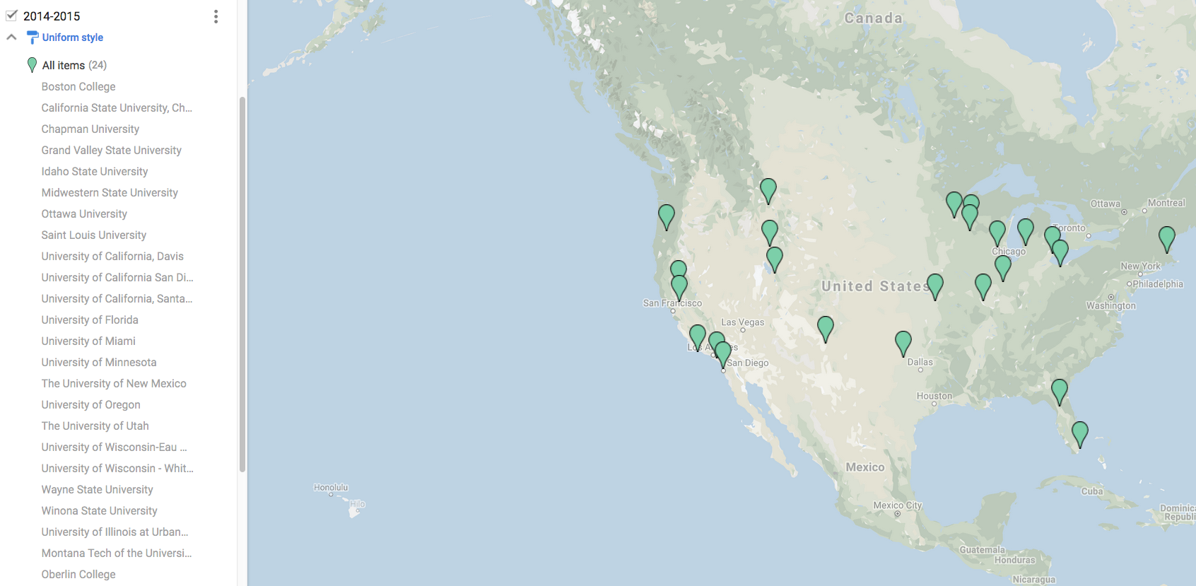
Dr. Corné Kreemer: Research Associate Professor, Department of Nevada Bureau of Mines and Geology, and Seismological Laboratory | University of Nevada, Reno
 Corné Kreemer is a geophysicist as the University of Nevada, Reno, where he is a Research Associate Professor jointly in the Nevada Bureau of Mines and Geology and the Nevada Seismological Laboratory. He received his B.S. and M.S. in Geophysics at Utrecht University, in his native Netherlands. Growing up in a country devoid of mountains and earthquakes, he has always been fascinated by the forces that created the spectacular landscapes abroad. Corné received his Ph.D. from Stony Brook University, where he harnessed the new availability of GPS velocities to model strain rates across the Earth's (diffuse) plate boundary zones. His work led to a quantitative refinement of the textbook picture of plate tectonics being explained by the motion of rigid plates separated by narrow boundaries. Since being in Reno, he has helped expand high-precision GPS observations across the Intermountain West. A particular focus has been on the Colorado Plateau, an area long thought to behave as a small tectonic block, but his work has made it clear that it is slowly deforming possibly in relation to processes in the mantle below. Corné is available to talk about his GPS work in the Intermountain West in the Fall of 2013 or Spring of 2014.(See More)
Presentation: The Slow-but-Steady Deformation of the American West: New Constraints from GPS Geodesy
Before the age of GPS geodesy, much was unknown about the patterns and rate of deformation in the Intermountain West. The slow deformation rate results in relatively few earthquakes, rare large events, and slip rates on faults that are very low and hard to infer in paleoseismic studies, because the last large event occurred so long ago. Much has changed with the introduction of GPS measurements, particularly those from continuous GPS (CGPS) stations. Many new stations were installed through EarthScope's Plate Boundary Observatory, and additional densification has come from EarthScope projects spanning the Rio Grande Rift and Colorado Plateau with CGPS stations. These stations yield horizontal velocity estimates that have a precision of a few tenths of mm/yr.
This talk will present the latest GPS results from Montana to New Mexico. It has now become clear that deformation in the Intermountain West is distributed rather heterogeneously, in a way that defies our common perceptions. For example, deformation in the Basin and Range is rather heterogeneous with zones of relatively high deformation rates separating areas that behave much more rigidly. On the other hand, the Colorado Plateau does not simply behave as the rigid rotating tectonic block that it has been for eons, but rather is slowly spreading apart. And the Rio Grande Rift appears unlike a quintessential continental rift, but more as the eastern limit of a large extending area.
This talk will try to place these findings in the context of what is now known about the structure and deformation of the underlying mantle. The findings also warrant a reconsideration of the region's seismic hazards and a need to reconcile the geodetic deformation rates with low earthquake activity and a dearth of active faults.
Dr. Michael Oskin - Associate Professor, Department of Geology | University of California, Davis
 Mike Oskin's interest in earthquake geology was sparked by growing up in southern California, camping with his family in the southwestern U.S., and, especially, his up-close experience of the 1992 Landers-Big Bear earthquake sequence while hiking in the San Bernardino mountains. He received a B.S. in engineering geology from the University of California, Los Angeles, in 1995 and a Ph.D. in geology at the California Institute of Technology in 2002. Afterwards, he spent two years as a research scientist at U.C. Santa Barbara and four years as an assistant professor at the University of North Carolina, Chapel Hill. He then moved to the University of California, Davis in 2008. Mike's research program focuses on understanding active crustal deformation and its expression in topography. Problems he works on include quantifying secular variation of deformation rates and earthquake production, constraining the forces and processes that govern distributed continental deformation, and predicting topographic responses to the growth of geologic structures. He combines geological fieldwork, high-resolution remote sensing and laser altimetry (LIDAR) analysis, and a variety of Quaternary geochronologic techniques. He is available for talks in the Fall and Spring of 2013-2014.(See More)
Presentation: Fault System Behavior Revealed in High-Resolution Topography
Dr. Oskin's talk will focus on fault-system behavior and the trade-off between fault slip and distributed deformation of the crust as revealed by Late Quaternary deformation in southern California, and by differential LIDAR the 2010 El Mayor-Cucapah earthquake rupture in northern Baja California.
Dr. Ken Ridgway - Professor, Department of Earth, Atmospheric, and Planetary Sciences | Purdue University
 Ken Ridgway's research centers on tectonics, sediment transport, and basin development along convergent margins. Much of his work has focused on the Mesozoic and Cenozoic development of the southern Alaska convergent margin, the evolution of sedimentary basins in the Taiwan collisional zone, and upper plate deformation related to flat slab subduction in Argentina and Alaska. Ridgway actively collaborates with geophysicists to better integrate deformational processes along convergent margins from the mantle to the surface. Integration of geological and geophysical data, for example, show that active collisional processes shape the southern margin of Alaska mainly through shallow subduction, crustal shortening and strike-slip deformation, large-magnitude earthquakes, rapid uplift and exhumation of mountain belts, and high sedimentation rates in adjacent basins. Ridgway’s curiosity about how the Earth works and his Native American heritage has also led him to the broad question of the relationship between "Western" science and indigenous communities. He helped develop a program at Purdue University that is unique in that it encourages Native students to work on thesis projects on Native lands. Many Native communities often associate earth scientists with "outsiders" coming on to reservation lands to take resources and/or to impose new government rules. As a result, they do not think that science and engineering can actually be beneficial to their home communities. Many of the Native graduate students in the Purdue program are addressing this misconception by working on research projects in their home communities. He is available for talks in the Fall and Spring of 2013-2014.(See More)
Presentation: Upper plate response to Cenozoic flat slab subduction processes in southern Alaska, and educational outreach opportunities with Native American communities
Southern Alaska contains a rich record of upper plate processes related to active subduction of a flat slab. Shallow subduction of thick oceanic crust along this convergent margin has prompted crustal shortening, exhumation, inversion of sedimentary basins, and cessation of magmatism above the area of ongoing flat slab subduction. Surface uplift and erosion above the flat slab region results in deposition of thick, Neogene clastic wedges in sedimentary basins located along the western, northern, and southern perimeters of the flat-slab region. Along the eastern perimeter, northwestward-propagating Oligocene–Quaternary slab-edge volcanism and transtensional basin development along dextral strike-slip faults record northwestward insertion of a shallow slab against the curved continental margin of eastern Alaska. Collectively, integration of geological and geophysical data indicates that Cenozoic flat slab subduction has had a direct role in the regional tectonic configuration of the upper plate along the southern Alaska convergent margin.
I will also discuss potential educational outreach strategies for developing research and teaching relationships with Native American communities and their students. As an example, I will discuss a Purdue program that encourages Native students to work on thesis projects on Native lands. We have found that when Native students realize that through science and engineering that they can assist and work directly with their home communities, then they are much more interested in these subject areas. In the research projects by Native American graduate students at Purdue, elders and experienced members of the tribal communities are involved to incorporate existing indigenous knowledge within the local communities. This type of approach allows Native American graduate students to solve problems important to their home communities using the latest tools of science, engineering, and technology while incorporating the experience and knowledge these communities have acquired from living in the same area for thousands of years.
Dr. Mousumi Roy - Associate Professor, Department of Physics and Astronomy | University of New Mexico
 Mousumi Roy is a geophysicist at the University of New Mexico where she is a professor in the Department of Physics and Astronomy. She graduated with a BS in Physics from Stanford University and went on to a PhD program in Physics at Boston University. While at BU, she became interested in geological applications of physics and math and realized that geophysics would be a fruitful way to combine her interests in both physics and earth science. She studied geophysics at the Massachusetts Institute of Technology, focusing on mountain building and plate tectonics, and received her PhD in 1997. Mousumi's primary research interests include the regional-scale tectonic process that shape continental lithosphere, including the Cenozoic evolution of the western US. She is also interested in mesoscale processes such as magma infiltration into the lithosphere and how it affects the physical and chemical state of the plate. She has been involved in a number of EarthScope projects including GPS observations to determine the kinematics of the Rio Grande Rift, geodynamic modeling of mantle deformation and anisotropy beneath the San Andreas Fault, and also magmatism and melt-migration into the Colorado Plateau. She is available for talks in the Fall and Spring of 2013-2014.(See More)
Presentation: How Cenozoic Magmatic Patterns in the Western US and their Relation to Evolution of the Colorado Plateau
Using the Colorado Plateau as a natural laboratory, this talk investigates how plate-interior heterogeneities within North America may control Cenozoic patterns of deformation and magmatism in the western US. The talk will focus on the effects of heterogeneities in the lithosphere-asthenosphere boundary (or LAB), such as regions of thicker-than-average lithosphere, and how these regions may undergo modification and evolution by the interplay between deformation, magma-migration, and infiltration. Dr. Roy will present geodynamic models that assume a temperature-dependent viscosity in the mantle, with melt-migration represented using a series of assumptions. The simplest case considered is that of Darcy flow within the mantle, where the separation of melt from the solid is driven by buoyancy and by dynamic pressure gradients. We find that dynamic pressures (linearly proportional to asthenosphere viscosity) within the protruding lithosphere may display a pronounced asymmetry along the flow direction. In general, the asymmetry in dynamic pressures causes an asymmetry in melt migration: melt is driven into the upwind side of the protrusion and away from the downwind side.
The second part of the talk will focus on the physical implications of melt-migration into protrusions at the LAB and draw connections to both geologic and geophysical observations at the Colorado Plateau, particularly seismic structures illuminated by EarthScope data. At the Colorado Plateau, this potential asymmetry in dynamic pressure gradients may manifest itself in a clear difference between the SE margin (upwind side relative to the direction of uppermost mantle flow beneath North America), where we observe the highest rates of magmatic encroachment, and the NE margin (downwind side) where there is a distinct lack of magmatic encroachment. The predicted rates of magmatic encroachment and migration from our calculations are consistent with observations from the ages and distribution of igneous rocks surrounding the Colorado Plateau. Additionally, we will assess whether seismic observations (such as shear wave speed and attenuation) support this interpretation of the magmatic patterns and limitations of the models. The talk will consider whether the process of magma-infiltration into the base of lithospheric protrusions may modify the physical and chemical state of the lithosphere, essentially rejuvenating it and causing a migration of the LAB.
Dr. Anne Sheehan - Professor of Geophysics, Department of Geological Sciences | University of Colorado at Boulder
 Anne Sheehan received her undergraduate degree in Geophysics from the University of Kansas in 1984 and a Ph.D. in Geophysics from the Massachusetts Institute of Technology in 1991. After postdoctoral research at Lamont-Doherty Earth Observatory of Columbia University and the University of Nevada, Reno, Sheehan joined the faculty at the University of Colorado at Boulder in 1993. She is currently a Professor of Geological Sciences at the University of Colorado at Boulder and a Fellow of the Cooperative Institute for Research in the Environmental Sciences. Sheehan's research interests include the study of crust and upper mantle structure of the Earth and its relation to tectonic deformation, particularly beneath mountains and plate boundaries. Much of her work includes the deployment of portable seismometers that record both distant and local earthquakes. She has led recent seismic experiments in the Himalaya, New Zealand, and the Rocky Mountains. Sheehan is principal investigator of an ongoing EarthScope GPS experiment to study the Rio Grande Rift in New Mexico and Colorado, and is a co-PI of the EarthScope Bighorn Seismic Experiment in Wyoming. Anne is available for talks in the Fall and Spring of 2013-2014.(See More)
Presentation: The Roots of the Rockies: Deep crustal imaging of thick-skinned fold and thrust belts
Foreland mountain belts consisting of basement-involved arches are major features of many contractional orogens. These thick-skinned fold and thrust belts occur between cratonic interiors and more intensely shortened compressional orogenic belts. They occur most prominently during low-angle subduction (e.g., the Rocky Mountains of North America and Sierras Pampeanas of South America) and continental collision (e.g., the Tien Shan in Asia). The dissimilarity between thick-skinned, arch-dominated and more thin-skinned fold and thrust belts as well as their placement far from active tectonic boundaries prompts the following question: do these arches form due to the lithospheric rheology inherent to the zone between mobile belts and cratons, or are they driven by deeper processes such as low-angle subduction?
Previous geologic and geophysical studies have shown that the upper crustal geometries of fault networks bounding these arches are broadly similar, hence, they may arise from similar lithospheric conditions. However the manifestation of arch shortening at depth and the rheology of the lower crust and upper mantle has been uncertain due to the absence of detailed geophysical imaging, leaving the question of conditions driving deformational style unanswered. This situation is changing rapidly, as foreland arches are the target of deep seismological investigations including in the western United States as part of EarthScope. In this presentation Dr. Sheehan will present recent results from a major passive and active source EarthScope Flexible Array seismological experiment in the Bighorn Mountains in Wyoming.
Dr. Ben van der Pluijm - Professor of Geology and the Environment, Department of Earth and Environmental Sciences | University of Michigan
 Ben van der Pluijm is the Bruce R. Clark Collegiate Professor of Geology and Professor of the Environment at the University of Michigan. He arrived at the U-M in 1985, after completing degrees in structural geology at Leiden (Netherlands) and New Brunswick (Canada). His research focuses on deformation of the Earth’s crust, ranging from microscope to mountain belt, using laboratory methods that include X-ray analysis, thermochronology, electron microscopy, geochemistry and rock magnetism. Current topics of his research group are fault rock formation, deformation dating, fluid fingerprinting and orogenic curvature; current field areas are in the U.S., Canada, Mexico, Spain, Japan, Turkey and New Zealand. In addition to teaching lower and upper level courses in Global Change and Earth Structure, he directs the interdisciplinary, team-taught Global Change Degree Program. His educational interests include the use of modern technologies to enhance students' learning experiences in the field (GeoPad) and classroom interactivity (LectureTools).
Ben has served in many department, college and university roles. In the Provost Office, he headed the U-M’s activities for reaccreditation and a campus-wide self-study on internationalization and global engagement, completed in 2010. He chaired the President's campus-wide Interdisciplinary Learning Initiative. In 2012, he returned from the National Science Foundation where he coordinated its cross-directorate sustainability initiative (SEES). Ben has served on a range of (inter)national agency panels and organizations. His editorial roles include editor of GEOLOGY, ~dozen editorial boards and editor of several book volumes; he has (co-)authored >175 articles, and published two editions of the textbook "Earth Structure."
Ben is a Fellow of the AAAS and the Geological Society of America, and recipient of multiple teaching, service and research awards. He is available for talks in the Fall and Spring of 2013-2014.(See More)
Presentation: Smart Clays: Fault Lubrication and Creep on the San Andreas Fault
Active faults accommodate motion between crustal blocks through a range of behaviors. At one end, earthquakes represent sudden and violent rupture; at the other end lies a steady, creeping motion that does not generate significant seismic activity. The properties that govern these behaviors are central to fault rupture processes and associated seismic hazards, and have been variably attributed to (i) low values of normal stress, (ii) elevated pore-fluid pressure, and (iii) low frictional strength. The San Andreas Fault in California exhibits different types of slip behavior, including large damaging earthquakes and segments that are creeping aseismically today.
However, faults are not simple planar surfaces marking the contact between moving blocks. Instead, they are complex and evolving structures, and are often filled with fault rock. Fault rocks collected from SAFOD drilling are abundantly coated by polished thin-films of hydrated clay with occasional striations. Microscopy and X-ray studies of these surface coatings reveal the occurrence of both illite-smectite (I-S) and chlorite-smectite (C-S) phases. Ar dating of illitic clay coatings shows that they are neocrystallized phases that grew in the modern fault zone. It is proposed that fault creep is controlled by networks of thin (~ 100 nm thick) nanocoatings on fracture surfaces that are sufficiently interconnected to allow slip with minimal breakage of stronger matrix clasts. Displacements are accommodated by frictional slip along particle surfaces coated with smectitic phases. Indeed, recent experimental work on I-S fault rocks shows very low frictional strength and significant weaknesses compared to neighboring wall rocks.
The stability of smectite in chloritic phases extends the role of clays to depths up to ~10 km, so we conclude that the localization of smectitic clay minerals promotes fault creep behavior without requiring scenarios involving talc/serpentine phases or localized fluid pressure as explanations for mechanically-weak upper crustal faults.
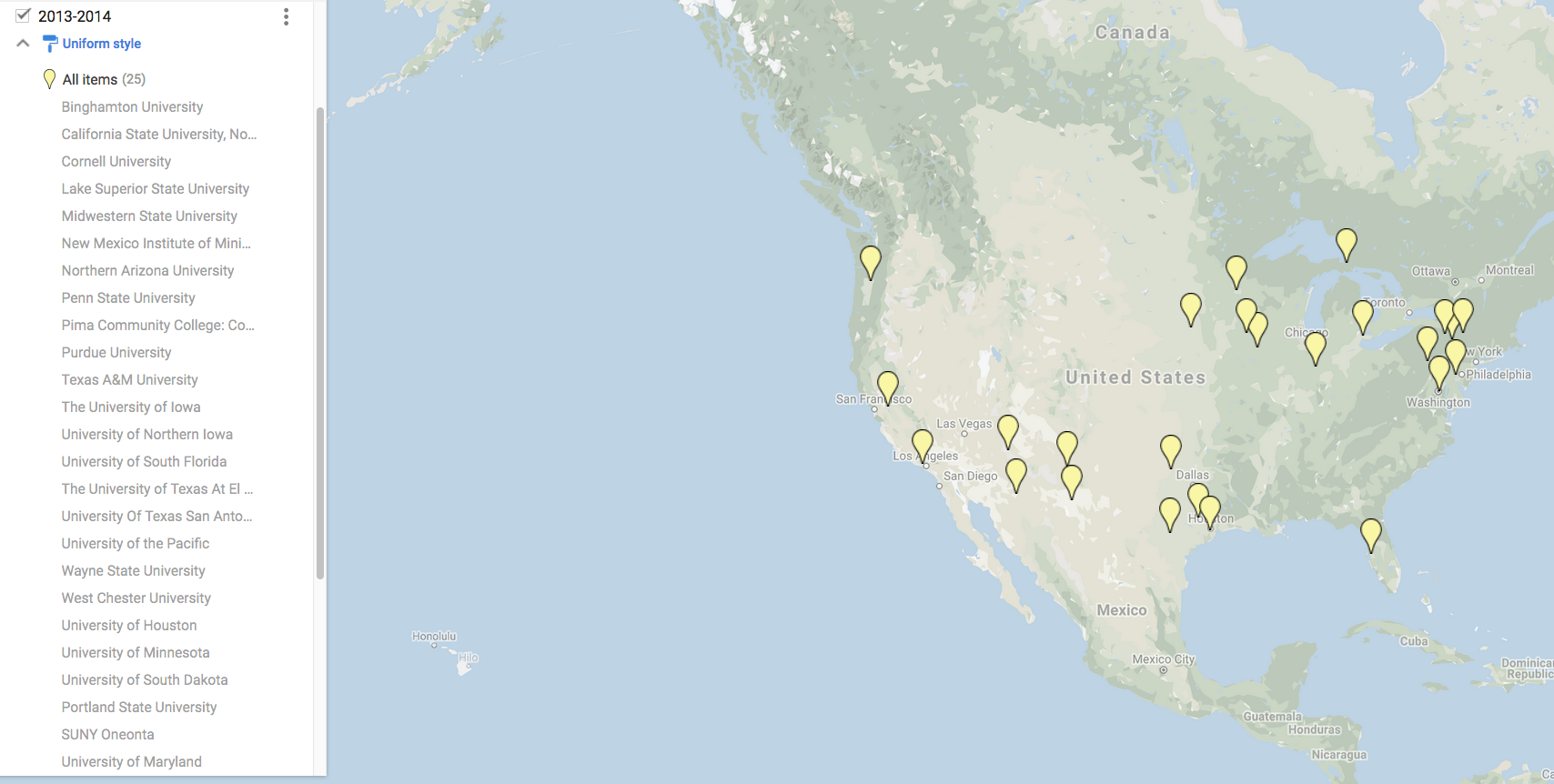
Dr. Kristine Larson: Professor, Department of Aerospace Engineering Sciences | University of Colorado
 Kristine M. Larson is a geodesist at the University of Colorado where she is currently a professor in the Department of Aerospace Engineering Sciences. After graduating with a B.A. in engineering sciences from Harvard University in 1985, she studied geophysics at the Scripps Institution of Oceanography, where she received a PhD in 1990. Kristine's initial research interests focused on measuring regional crustal deformation and plate motions with GPS. In the late 1990s her group moved to bigger signals, developing methods to improve high-rate GPS measurements so that they could be used to study earthquake ruptures, ice sheet motions, and volcanic eruptions. Her research group is now focused on using reflected GPS signals to study the water cycle: soil moisture, snow, and vegetation. These data are important for climate studies, water management, and weather forecasting, thus improving, and possibly mitigating, natural hazards such as floods and droughts while improving agricultural production. She currently leads the PBO-H2O initiative. Kristine will be speaking on using the EarthScope Plate Boundary Observatory to study the earth’s water cycle. She is available for talks in the fall and spring of 2012-2013. (See More)
Presentation: Using the EarthScope Plate Boundary Observatory to Study the Earth's Water Cycle
The EarthScope Plate Boundary Observatory was built to study the deformation of the North American continent. A major component of this geodetic initiative is a GPS network of over 1100 instruments which are capable of measuring mm-changes in position over time scales of hours to years. Now that the PBO network has been completed, innovative uses of these GPS data have been demonstrated which are providing a strong link between this new, state-of-the art geodetic facility and non-geodetic fields of research, specifically water cycle research.
In this talk I will briefly summarize how GPS is able to measure both small fault motions and seismic signals, and then explain how the reflected signals used to study the water cycle are being retrieved from the GPS data. These GPS reflections are being used to measure how much water is in the surface soil layer, how much snow is on its surface, and the water content of vegetation surrounding the GPS station. Observing and monitoring spatial and temporal changes in these parameters is critical for both understanding and predicting the Earth's climate. In the past year, PBO recorded both the low snowpack levels in the Rocky Mountains during the winter and pervasive drought effects in soil moisture levels and vegetation this summer. These new water cycle data are being made available through the auspices of the PBO H2O initiative. For more information, see my website: http://spot.colorado.edu/~kristine
Dr. Matt Pritchard: Associate Professor, Department of Earth and Atmospheric Sciences | Cornell University
 Matt Pritchard got hooked on geology through a 4-H club project while growing up on an Illinois farm far from any rock outcrops. Matt is currently an associate professor of Earth and Atmospheric Sciences at Cornell University. He received a B.A. degree in Physics from the University of Chicago and M.S. and Ph.D. degrees in Geophysics from Caltech. He spent a year as a Harry Hess Postdoctoral Fellow at Princeton University. His primary research interest is measuring changes in the shape of the Earth caused by earthquakes, volcanoes, landslides, glaciers, and human activities. Some of his primary tools are: InSAR (Interferometric Synthetic Aperture Radar), pixel tracking using both SAR and optical images, GPS, and numerical models. He has taught courses in geophysics, active tectonics, remote sensing, and planetary science, and is currently writing a free textbook about geodetic imaging as part of an NSF CAREER award. Matt currently serves on the oversight committees for UNAVCO and the GeoPRISMS program and is a member of the science team for the orbiting ASTER instrument and the science definition team for the proposed DESDynI-R mission. Matt will discuss why InSAR is important to EarthScope, how to get access to that data, how to set up a processing capability, and what types of problems this data can and cannot be used to address. Interferograms of the host institution will be presented. He is available for talks in the spring of 2013. (See More)
Presentation: Towards a pixel-by-pixel view of North America's changing surface using geodetic imaging
For centuries, measurement of the shape of the Earth (called the science of geodesy) was necessarily time consuming. Even with new technologies like the Global Positioning System (GPS), vast portions of the Earth remain infrequently monitored for movement. Recently, a new form of geodesy has rapidly developed whereby image pairs can be compared to infer movements of the Earth's surface. Called geodetic imaging, the synoptic aircraft or satellite views allow large regions to be surveyed densely without any human setting foot in the area. Imaging geodesy encompasses several different types of methods including Interferometric Synthetic Aperture Radar (InSAR) as well as the automated comparison of SAR and optical images via pixel tracking. InSAR can image sub-centimeter deformation of the Earth's surface every 1-20 meters over areas spanning hundreds to thousands of kilometers. Pixel tracking is a very complementary tool to InSAR-- although the sensitivity to deformation is less (decimeter instead of sub-centimeter in a given image pair) and the horizontal spacing is coarser, it can be applied to both radar and optical images and often works when InSAR does not – for example, in areas that have large displacements or changes to the radar scattering properties of the ground.InSAR has allowed vast areas of the Earth's surface to be monitored frequently for deformation for the first time and this presentation will highlight some of the discoveries in North America and elsewhere, selected with input from the host institution. Possible topics include earthquakes/tectonics, magmatic processes in the Basin & Range and globally, landslides, glaciers (especially in Alaska), groundwater, changes in vegetation, and human-induced ground deformation.A US InSAR mission was part of the original Earthscope plan. While the US InSAR mission (currently called DESDyni-R) is not likely to launch until 2019, Earthscope (along with NASA and others) has facilitated access to InSAR data over North America from several foreign satellite missions from 1992-present. There will soon be more than 300 Terabytes of raw SAR imagery available through UNAVCO and the Alaska Satellite Facility. Most of this data is from the Japanese ALOS mission which had a radar wavelength of 23 cm that is capable of making coherent interferograms over most of North America for the first time. This presentation will discuss how to get access to that data, how to set up a processing capability, and what types of problems this data can and cannot be used to address. Interferograms of the host institution will be presented.
Dr. Bob Butler: Professor, Department of Environmental Studies | University of Portland
 As an undergraduate student, Bob Butler struggled to decide between physics and geology until he happily learned that geophysics was a science that applied physics to studies of the Earth. He became a researcher in paleomagnetism and tectonics with field projects in remote regions of six continents. Eventually he discovered the joys of engaging middle-school teachers in the wonders of geology and geophysics and launched an encore career in geoscience education. Bob is Director of Teachers on the Leading Edge (TOTLE), a professional development program for secondary Earth science teachers featuring EarthScope discoveries and Cascadia earthquake and tsunami hazards and mitigation. He is a co-author of Incorporated Research Institutes for Seismology (IRIS) Recent Earthquakes Teachable Moments and is working with IRIS Education and Public Outreach to develop IRIS: InClass, an online earthquake education resource center. Bob received his B.S. from Oregon State University and his M.S. and PhD degrees from Stanford University. He was a post-doctoral fellow at the University of Minnesota and a University Distinguished Professor at the University of Arizona Department of Geosciences before moving to the University of Portland in 2004. Bob is a Fellow of the American Geophysical Union and the Geological Society of America and is an avid skier and cyclist. He currently teaches general education courses on Earth System Science, Natural Hazards, and Introductory Marine Science. Bob’s talk will focus on engaging novice Earth science learners in EarthScope science. He is available in both the fall and spring semester of 2012-2013.(See More)
Presentation: Engaging Novice Earth Science Learners in EarthScope Science
The EarthScope Program was approved by Congress in part because the science is relevant to geologic hazards: EarthScope will provide a foundation for fundamental and applied research throughout the United States that will contribute to the mitigation of risks from geological hazards, the development of natural resources, and the public's understanding of the dynamic Earth. Given the technological sophistication of EarthScope seismology and geodesy research, the latter claim can appear unattainable and the challenge of engaging students and the public in EarthScope science is initially daunting. To approach this goal, geoscience educators must translate EarthScope science for novice learners and make that science inviting, accessible, and useful. Education and Outreach personnel with the EarthScope National Office (ESNO), IRIS, and UNAVCO have developed educational resources and programs that are bringing EarthScope to millions of people, including educators, students and visitors to parks and museums. Teachers on the Leading Edge (TOTLE) is a place-based K-12 Earth science teacher professional development program featuring EarthScope science and Cascadia geologic hazards. During summers of 2008 to 2010, TOTLE offered a six-day workshop in which participants learned how geoscientists developed our current understanding of Cascadia earthquakes, tsunamis, volcanoes and associated hazards and how EarthScope research is advancing frontiers of geoscience knowledge. Drawing on the Orphan Tsunami of 1700, TOTLE and collaborators developed classroom activities inviting students to approach Cascadia tsunami geology as a Crime Scene Investigation through which they gain understanding of plate tectonic processes, such as the earthquake cycle. A key feature is lesson plans that progress from a basic one-class-period lesson (e.g. Gum Drop GPS) to an intermediate-level enhancement (e.g. Cascadia Locked and Loading) to a more advanced investigation (e.g. Episodic Tremor and Slip). Inquiry-based learning about great Cascadia earthquakes and tsunami aligns well with National Science Education Standards; provides a case study of scientific discovery, an important benchmark of science literacy; and emphasizes science, technology, and societal connections through consideration of geologic hazards. These motivations have been dramatically reinforced by the Chile 2010 and Japan 2011 great earthquakes and resulting Pacific-wide tsunami. Although TOTLE classroom activities were designed for secondary Earth science students, the analyses of EarthScope GPS and seismic observations, as well as associated animations and manipulative models, can easily be adapted for college-level general education courses.
Dr. Graham Kent: Director and Professor, Department of Geological Science and Engineering | University of Nevada
 Graham Kent spent his youth rock climbing in the High Sierra near his home town of South Lake Tahoe, which spurred an early interest in the earth sciences. In many respects, his life has gone full circle upon returning in 2009 to the Nevada Seismological Laboratory at University of Nevada, Reno, where he is both Director and Professor within the Department of Geological Sciences and Engineering. Before returning back to the Tahoe region, he attended San Diego State University, where he studied Geophysics and graduated Valedictorian of the Class of 1985. Soon thereafter, he entered graduate school at Scripps Institution of Oceanography receiving his PhD in 1992. After a 4-year-long appointment at Woods Hole Oceanographic Institution, Graham returned to Scripps to continue his work in geophysics, with an emphasis toward active-source seismic studies of extensional tectonics, ranging from magma chambers beneath mid-ocean ridges to fault hazards in the Lake Tahoe basin. More recently, he helped co-lead an effort to develop underwater methods for paleoseismic investigations using advanced sonar imaging tools to study fault slip-rates and recurrence intervals. Dr. Kent has conducted a variety of studies around the globe, including ocean bottom seismic research. He’s also mapped earthquake faults beneath Lake Tahoe that have produced tsunamis in the past and most recently has placed important constraints on southern San Andreas Fault recurrence times through mapping of cross faults beneath the Salton Sea. Last year, he also led the 2nd Annual Great Nevada Shakeout earthquake drill in partnership with the Great California Shakeout, the largest combined public earthquake drill in the world. Graham will talk on the developments of underwater paleoseismic techniques as an application to transensional environments along the Western U.S. plate boundary. He is available in the fall and spring semesters of 2012-2013.(See More)
Presentation: Development of underwater paleoseismic techniques: An application to transtensional environments along the Western U.S. plate boundary
The development of underwater paleoseismic techniques using advanced sonar imaging along with sediment coring/dating provides a useful framework to assess the potential risk of offshore faults to nearby communities. Lakes and shallow seas by their very nature providean ideal environment for the preservation of process through a detailed stratagraphic record. Deployment of a digital SUBSCAN CHIRP profiler in lakes and shallows seas along the western U.S. plate boundary provides a glimpse into the development of underwater paleoseismic techniques, including assessment of fault slip-rate and event chronology. Examples from the Walker Lane (Lake Tahoe, Pyramid Lake and Walker Lake) and the southern San Andreas (Salton Sea) will be presented. Walker Lane research highlights both detailed mapping of faults beneath the many rift lakes, including a detailed understanding of strain partitioning in these systems. Mapping event chronologies for cross-faults beneath the Salton Sea reveals a relationship between the flooding of ancient Lake Cauhilla and triggering of the underlying normal faults connecting the Imperial Fault to the Southern San Andreas Fault. Comparison of timing between ruptures of flood-induced cross-faults and ruptures along the southern San Andreas Fault has uncovered a potential coupling between these two systems. An introduction to the latest synthetic aperture sonar (SAS) CHIRP profiler developed at EdgeTech, Scripps Institution of Oceanography and the University of Nevada, Reno will also be highlighted. This new device has the potential to image 300-400 m beneath the subsurface with sub-meter resolution
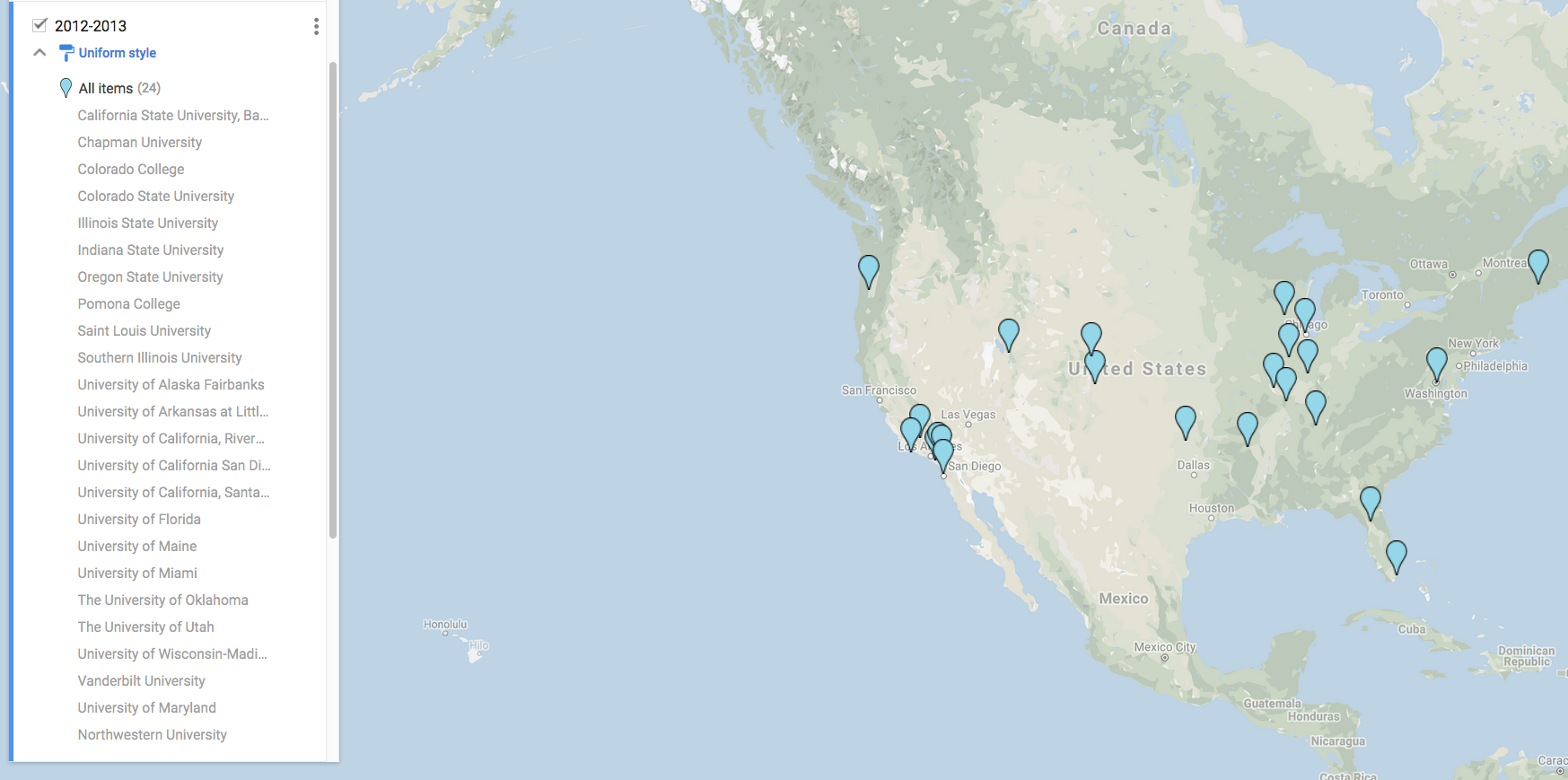
Dr. Lucy Flesch: Associate Professor, Department of Earth and Atmospheric Science | Purdue University
 Lucy Flesch is a geodynamicist who's research is focused on continental plate boundary zones where plate-tectonic theory tends to break down. Dr. Flesch seeks to answer fundamental questions relating to: 1) quantifying the forces driving deformation in continental lithosphere, especially deformation far inboard from a plate edge; 2) determining the contribution from the convecting mantle to surface motions; 3) assessing the level of coupling between the lithosphere and asthenosphere; and 4) determining the strength of the continental lithosphere. She addresses these issues through numerical modeling that integrates observed data from geology, geodesy, and seismology. Dr. Flesch received her B.S. in physics from Beloit College as well as M.S. and PhD degrees in geophysics from Stony Brook University. She was a post-doctoral fellow in the Department of Terrestrial Magnetism at the Carnegie Institution of Washington, DC, before joining the faulty at Purdue University.(See More)
Dr. James P. Evans: Professor, Department of Geology
Utah State University - Logan, Utah
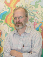 Jim Evans grew up in the iron-mining district of the Upper Peninsula of Michigan, and was first drawn to the geosciences via the exotic persona of 'geologists' who traveled the world. He received B.S. Geology and B.S. Engineering degrees from the University of Michigan in 1981, and M.S. and PhD Geology degrees from Texas A&M University in 1987. Jim has been at Utah State University since 1987, where he has received numerous awards for his teaching and research. His research focuses on a range of fault and fractured-rock related questions in all rock types across a range of P-T-pore-fluid conditions, including: the nature and implications of seismic slip in faults; energy budgets of earthquakes and rock deformation; hydrogeology of faulted and fractured rocks; the petrophysics of deformed and altered rocks as measured with borehole tools; geothermal processes; the microscopy and geochemistry of faults and shear zones; and energy resources. Jim has worked on several fault-drilling projects, including EarthScope's San Andreas Fault Observatory at Depth (SAFOD), and examined field sites in North America, Japan, Taiwan, and Vietnam. He was the chief editor of the Journal of Structural Geology from 2002-2007, and is a founding editor of the GSA journal Lithosphere.(See More)
Dr. Bridget Smith-Konter: Assistant Professor, Department of Geological Sciences
University of Texas at El Paso, Texas
 Bridget Smith-Konter began her science career with an interest in planetary physics in college, only to discover four years later that it was planet Earth that would truly "move" her. After receiving a B.S. in Physics and Astronomy from Northern Arizona University in 1999, Bridget began her PhD studies at the Scripps Institution of Oceanography (SIO) of the University of California-San Diego. On October 16, 1999, less than 1 month after beginning graduate school, the M7.1 Hector Mine earthquake struck southern California - and it was this event that jolted Bridget's interest in crustal deformation modeling of the San Andreas Fault System. After completing her PhD in 2005, she continued to pursue terrestrial crustal deformation research as a postdoctoral fellow at SIO. In 2007 she joined the Planetary Ices Group at Caltech/JPL, where she used her 3-D semi-analytic deformation and stress models to study faulting on icy satellites. Bridget is currently an Assistant Professor at the University of Texas at El Paso. Her research investigates vertical plate boundary deformation in California, techniques to integrate GPS and InSAR data, and shear failure models of icy faults on Saturn's moon Enceladus and Jupiter's moon Europa. She was recently awarded an NSF Early Career grant for her research involving EarthScope geodetic and paleoseismic data to develop 1,000-year earthquake cycle stress evolution models of the San Andreas fault system. Bridget currently serves on the EarthScope Education and Outreach Subcommittee and is actively involved in communicating the EarthScope 'message' to public audiences by developing unique visualization products and installing several IRIS Active Earth interactive kiosks in her local community.(See More)
Dr. Terry Plank: Professor, Lamont-Doherty Earth Observatory
Columbia University - Palisades, New York
 Literally born in a rock quarry in Delaware, Terry Plank had no other choice than to become a geologist. After mapping quartz diorites in high school and quartz monzonites while an undergraduate at Dartmouth College, Terry moved on to study volcanoes at mid-ocean ridges and subduction zones while getting her PhD at Lamont Doherty Earth Observatory of Columbia University. As a post-doc at Cornell University, and a faculty member at the University of Kansas and Boston University, she studied cycling of mass and fluids through subduction zones, from oceanic input to volcanic output, and contributed to laboratory studies to see what happens in between. Terry then moved back to Columbia University in 2008 where she now focuses on the volatile contents of magmas, specifically how water drives magma genesis, ascent and eruption. Field work has taken her to the Aleutian Islands, Nicaragua and out to sea. A fellow of the American Geophysical Union, Mineralogical Society of America and Geochemical Society, Terry has also served on the USArray Advisory Committee and the EarthScope Science Steering Committee. She is excited by EarthScope opportunities to combine petrology with seismology in exploring how melting occurs under the continents and what creates the lithosphere-asthenosphere boundary.(See More)
Dr. William L. Ellsworth: Geophysicist
U.S. Geological Survey - Menlo Park, California
 Bill Ellsworth is a seismologist interested in problems of seismicity, seismotectonics, probabilistic earthquake forecasting, and earthquake source processes. After graduating with a B.S. in Physics and M.S. in geophysics from Stanford University in 1971 he joined the earthquake research group at the U.S. Geological Survey in Menlo Park, California, which has been his professional home for the past 40 years. In 1974 he travelled east to the Massachussetts Institute of Technology, where he earned his PhD in geophysics in 1977. Bill's research focuses on questions of fault structure and earthquake source processes over a wide range of spatial and temporal scales. Over the course of his career, he has balanced his personal research with community service that has expanded opportunities and resources for seismology in the U.S. and around the world. He was a founder of the PASSCAL Program of IRIS, co-principal investigator of the San Andreas Fault Observatory at Depth (SAFOD) component of EarthScope, and currently serves on the steering committee of the Advanced National Seismic System (ANSS) and the National Earthquake Prediction Evaluation Council. Bill is a past President of the Seismological Society of America, a fellow of the American Geophysical Union, and recipient of the Distinguished Service Award of the Department of the Interior.(See More)
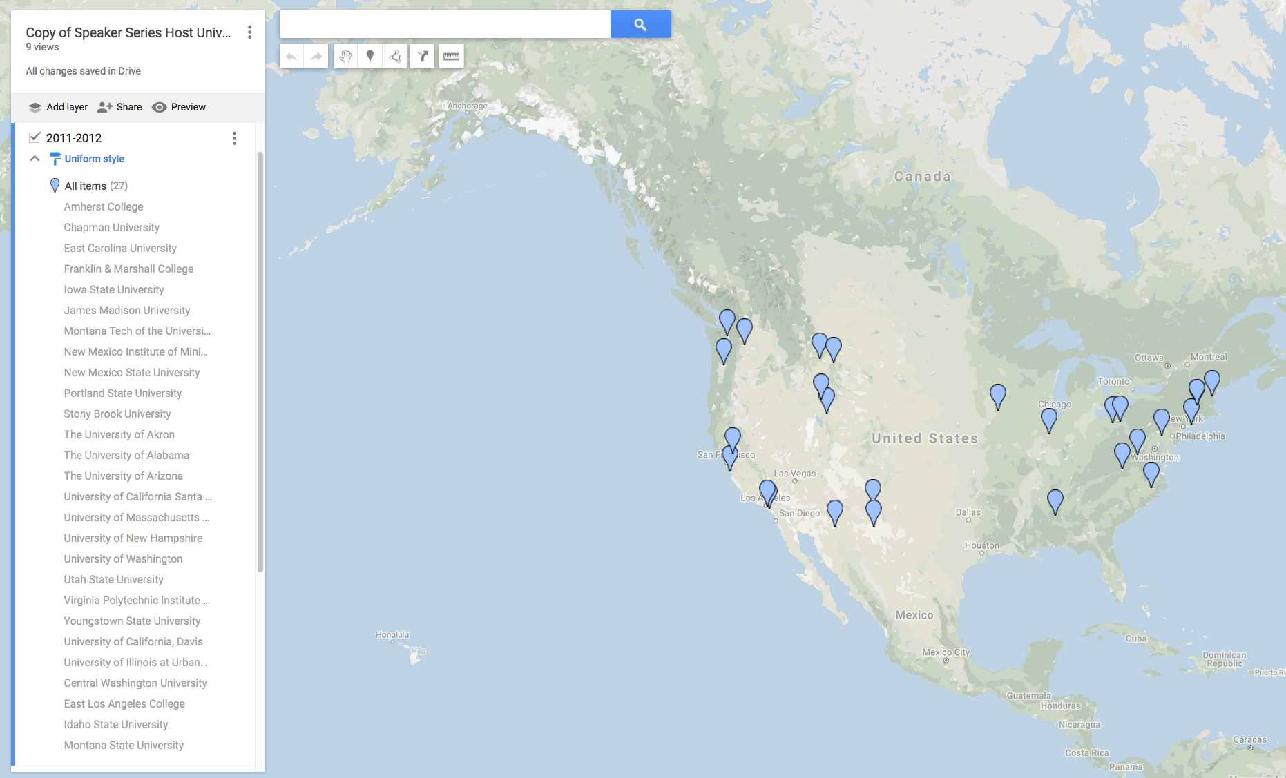
Dr. Kaj Johnson: Judson Mead Assistant Professor, Department of Geological Sciences | Indiana University
 Kaj Johnson has B.S. and M.S. degrees in Mathematics and Structural Geology from Purdue University, and a PhD in Geophysics from Stanford University. He works primarily with geodetic data and numerical and analytical models to investigate how deformation within plate boundary zones is accommodated by faulting and folding in the upper crust, and by viscous flow in the lower crust and upper mantle. His current research topics include: mountain building in Taiwan; afterslip and fault friction; relationship of interseismic and postseismic deformation to lithosphere rheology; and probabilistic inverse theory.(See More)
Dr. Meghan S. Miller: Assistant Professor, Department of Earth Sciences
University of Southern California - Los Angeles, California
 Meghan S. Miller is a structural seismologist with research focus on the interactions between upper mantle convection and surface geology, in particular the role of subduction and continental dynamics. Dr. Miller obtained her B.A. in physics and geology from Whittier College (1997), M.S. from Columbia University (1999), M.Eng. at Cornell University (2000) and PhD at the Australian National University (2006) and was a post-doc at Rice University and the University of British Columbia, before joining the faculty of the University of Southern California in 2009. She has studied mantle dynamics on a range of spatial scales, including plate boundary systems of the Caribbean and the western Pacific, the lithospheric structure beneath North America, and the core-mantle boundary. Dr. Miller employs a range of methods to address dynamical questions, from plate tectonic reconstructions, seismic tomography and receiver functions, to field studies. She is the chair of the IRIS Transportable Array Working Group (TAWG) and uses seismic data from the USArray stations to image the lithospheric structure beneath the western U.S. Her broadband seismometers are currently deployed in Morocco as part of a collaborative study of the westernmost Mediterranean. Dr. Miller's teaching interests include seismology, with focus on hands-on data analysis, tectonics, and visualization.(See More)
Dr. Gary L. Pavlis: Assistant Professor, Department of Earth Sciences
University of Southern California - Los Angeles, California
 Gary Pavlis received his B.S. degree in Engineering Physics from South Dakota State University and his PhD from the University of Washington in Geophysics. He joined the faculty of Indiana University in 1983. His research has spanned a range of topics including seismic imaging at a wide range of scales, applications of precision location techniques in seismotectonics and nuclear monitoring, array processing, and computational seismology. Dr. Pavlis has been involved in a long list of seismic experiments using IRIS instrumentation, including one or more experiments nearly continuously since 1990. His current work with EarthScope is focused on using Transportable Array data to produce high-resolution images of the upper mantle by employing a scattered-wave, three-dimensional method he recently developed, and integrating the images with other EarthScope results. (See More)
Dr. Harold J. Tobin - Professor, Department of Geoscience
University of Wisconsin - Madison Wisconsin
 Harold Tobin was first awed by the scale of plate boundary fault processes during summer fieldwork while completing his B.S. in Geology and Geophysics at Yale University in 1987. This led him to a literal plunge into the deep sea trenches for graduate school, and he completed his doctoral work at the University of California, Santa Cruz in 1995. After a postdoc at Stanford University, he joined the faculty of New Mexico Tech for 9 years. His research is focused on integrating fault geology with geophysical observations through the integration of laboratory petrophysical study of rock samples, borehole logging data, seismic reflection imaging, and structural analysis of fault materials. Dr. Tobin has worked extensively on offshore subduction zone faults during seven ocean drilling expeditions and two Alvin diving cruises, as well as onshore on the San Gregorio and San Andreas faults in California. He is currently torturing core samples from the San Andreas Fault Observatory at Depth (SAFOD) in the laboratory and is also serving as Chief Project Scientist for IODP's NanTroSEIZE program, one of SAFOD's sister projects in fault zone drilling. In 2006, Dr. Tobin moved to the University of Wisconsin at Madison, where he thrives despite being about as far from an active plate boundary as one can get. (See More)
Dr. Steven G. Wesnousky - Director, Center for Neotectonic Studies
University of Nevada - Reno, Nevada
 After receiving his high school diploma in Davis, California in 1970, Steve Wesnousky attended university with the main aim of throwing little white balls over a little white plate. Recognizing that such an activity might not lead to a long-lived career (and subsequent to experiencing a slide show of volcanoes to the music of Jimi Hendrix), Steve decided that geology might hold some promise. So in 1975 he obtained a B.A. in Geology from the University of California at Santa Barbara. Attracted by the potential to play basketball on the streets of New York City, Steve then enrolled in the graduate program at Columbia University and it's Lamont Doherty Geological Observatory. He played a few good games and received his PhD in Seismology in 1982. Since that time Steve has blended the geological and seismological disciplines to examine problems in seismic hazard analysis, fault mechanics, and active tectonics. He has been fortunate in his career to serve as the President of the Seismological Society of America from 1995-1997, receive Fulbright Scholarships for overseas studies in 1997 and 2005, be accorded recognition as a Foundation Professor at the University of Nevada-Reno, and be recognized as the university's most outstanding teacher in 2008. (See More)
Dr. Gene Humphreys: Professor, Department of Geological Sciences | University of Oregon - Eugene, Orego
 Since graduating from the California Institute of Technology and moving to the University of Oregon in 1985, Gene has been studying the nature and causes of western U.S. tectonics and magmatism. His main approach is to model the distortion of teleseismic waves as they propagate upward through the North American continent, to resolve the lithospheric structure. He has been involved in many regional deployments of seismometers, and his research incorporates data recorded by EarthScope's continental-scale USArray. To account for tectonic and magmatic activity, Gene synthesizes seismic results with geologic information and geodynamic modeling to resolve the force and temperature evolution of the western U.S. Recently he has begun a collaborative seismic and geodynamic study of the westernmost Mediterranean region, where similar lithospheric processes occur.(See More)
Dr. Robert B. Smith: Research Professor, Department of Geology and Geophysics | University of Utah - Salt Lake City, Utah
 Bob Smith's research interests are in seismology, tectonophysics, crustal deformation using GPS and active tectonics. His current research projects include: 1) geodynamics and evolution of the Yellowstone hotspot; 2) seismicity and volcanic hazards of Yellowstone and operation of the Yellowstone seismograph network; and 3) crustal deformation and earthquake hazards of extensional tectonic regimes including the Wasatch and Teton faults using GPS and fault modeling. His teaching includes tectonophysics and elastic waves, theoretical seismology, earthquake seismology and earthquake hazards, and introductory earthquakes and volcanoes.(See More)
Dr. Emily E. Brodsky: Associate Professor, Earth & Planetary Sciences Department | University of California at Santa Cruz - Santa Cruz, California
 Emily Brodsky has a B.A. degree from Harvard University and a Ph.D. from the California Institute of Technology. Her research interests include the physics of earthquake and volcanic eruptions by using fluid dynamics to formulate new interpretations of seismic and other geophysical data. She focuses on three general areas: earthquake triggering, friction, and co-eruptive seismic studies.(See More)
Dr. Mark Zoback: Professor of Geophysics | Stanford University - Palo Alto, California
 After receiving his PhD in Geophysics from Stanford University in 1975, Mark Zoback was a research geophysicist at the U.S. Geological Survey and, from 1981-1984, Chief of the Branch of Tectonophysics. He has been a Professor of Geophysics at Stanford since 1984. His principal research interests are related to quantifying the forces that act within the earth's crust and their influence on plate tectonics, earthquake mechanics and geomechanical processes affecting oil and gas exploration and production and CO2 sequestration. He was the co-Principal Investigator of the SAFOD project, an NSF-funded research project to drill, test and sample an actively deforming segment of the San Andreas Fault at seismogenic depth. He has authored, or co-authored, approximately 250 technical papers and one book (Reservoir Geomechanics, published in 2007 by Cambridge University Press). In 2006 Dr. Zoback was the recipient of the Emil Wiechert Medal of the German Geophysical Society and the co-recipient of the New Zealand Geophysics Prize. In 2008 was awarded the Walter Bucher Medal of the American Geophysical Union for original contributions to the basic knowledge of Earth's crust.(See More)
Dr. Ramon Arrowsmith: Associate Professor of Geology | Arizona State University - Tempe, Arizona
 J Ramon Arrowsmith conducts research in active tectonics, quantitative structural geology and geomorphology. These topics include paleoseismology; earthquake geology; theoretical studies of faulting and hillslope development; and Quaternary Geology and desert surface processes. Active areas of geographic concentration include Arizona, the San Andreas Fault system, central Asia, Xinjiang China, Baja California, and the Afar region of Ethiopia (for the geologic context of paleoanthropologic studies). He also develops geoinformatics tools for cyberinfrastructure in the geosciences emphasizing high-resolution topography derived from LiDAR technology.(See More)
Judith Chester: Associate Professor of Geology, Department of Geology and Geophysics | Texas A&M University
J udith Chester is an Associate Professor of Geology in the Department of Geology and Geophysics at Texas A&M University. Her primary research focus is understanding the composition, structure and mechanics of crustal fault zones at all scales and determining what geologic data can tell us about the earthquake source. She also is involved in studies of creep compaction in reservoir rocks and folding and fracture in layered rock. Dr. Chester currently is serving as the leader of the Fault and Rupture Mechanics Interdisciplinary Focus Group of the Southern California Earthquake Center (SCEC). Her EarthScope work is part of the ongoing effort to understand the physical and chemical processes controlling faulting and earthquake generation along the San Andreas Fault and therefore relies heavily on data provided by the San Andreas Fault Observatory at Depth (SAFOD).(See More)
Dr Matthew Fouch: Associate Professor, School of Earth and Space Exploration | Arizona State University - Tempe, AZ
 Matt Fouch is Associate Professor of Geophysics in the School of Earth and Space Exploration at Arizona State University. His primary research interests are in imaging Earth's interior using seismology. Dr. Fouch’s current work focuses on the tectonics of western North America as revealed by data from seismic arrays, most notably EarthScope's USArray and the High Lava Plains seismic experiment. He is actively involved in efforts to bring seismic data into the classroom from elementary school to college levels, and is a frequent speaker at public science lectures and teacher workshops. Dr. Fouch recently received the prestigious Presidential Early Career Award for Scientists and Engineers (PECASE), in part for his work involving EarthScope.(See More)
Dr. Tim Melbourne: Associate Professor, Department of Geological Sciences | Central Washington University - Ellensburg, WA
 After receiving a BS degree in Geophysics from the California Institute of Technology, Dr. Melbourne spent two years conducting GPS studies at the Cascades Volcano Observatory of the U. S. Geological Survey. He then earned a PhD in Seismology, also from Caltech. Since 1999 Dr. Melbourne has been on the faculty at Central Washington University where he is Director of the PANGA Geodesy Laboratory. His research incorporates observations from EarthScope to investigate the deforming edge of the North American continent along the Cascadia Subduction Zone.(See More)
Dr. Suzan van der Lee: Assistant Professor, Department of Geological Sciences | Northwestern University - Evanston, IL
 Dr. van der Lee received an undergraduate degree in geophysics from the University of Utrecht (Netherlands) where she operated the NARS-NL mobile seismic network. She earned a PhD from Princeton University in 1996, using seismic waveform tomography to develop some of the first images of the structure of Earth’s mantle beneath North America. After her Ph.D. defense (which was conducted in the room where Walter Matthau lectured as Einstein in the movie I.Q.) she joined the Department of Terrestrial Magnetism at the Carnegie Institution in Washington, DC. There, she explored the mantle structure beneath South America and discovered striking similarities and differences with North America. Dr. van der Lee installed a portable seismic array in Zimbabwe and South Africa as part of the Kaapvaal Craton Project. During her subsequent five-year lectureship at the Swiss Federal Institute of Technology (ETH), she taught advanced undergraduate courses and supervised Ph.D. students. She initiated and managed the MIDSEA project in the Mediterranean region (including seismic stations on remote islands and in northern Africa), as well as the BLSP02 project in Brazil. Dr. van der Lee is currently an Assistant Professor at Northwestern University, where she interprets campaign and permanent-network seismic data (including EarthScope’s USArray) to unravel the dynamics of the solid Earth.(See More)
Dr. George Zandt: Professor, Department of Geosciences |University of Arizona - Tucson, AZ
 Dr. Zandt is Professor in the Department of Geosciences at the University of Arizona. After obtaining his BS degree in Geology from the University of Wisconsin-Milwaukee and his PhD in Geophysics from MIT, Dr. Zandt held research and teaching positions at the University of Utah, the State University of New York at Binghamton, and Lawrence Livermore National Lab. He joined the faculty at the University of Arizona in 1997. His primary research interests are in utilizing data from passive broadband seismology deployments to understand the deep structure and tectonic evolution of orogenic systems. He has been involved in field deployments in the U. S. and Canadian Cordillera, the South American Andes, and along the North Anatolian Fault in central Turkey. He is currently working on data from these regions as well as the EarthScope USArray data to understand the role of lithospheric delamination in mountain building.(See More)
EarthScope Speaker Series Location over time. Between 2008 and 2019, 55 speakers presented EarthScope related research in 210 institutions.


