

By Meghan Berg - Spring 2012
On August 23, 2011, the Mw 5.8 Mineral, Virginia, earthquake rocked the east coast of the U.S. While moderate in comparison to recent mega-thrust events in Japan, Chile, and Sumatra, and perhaps regular fare to those living on the active plate boundary in the western U.S., this earthquake serves as a reminder that seismic hazards on the east coast are real and not well documented. Ground shaking associated with the event was felt over a larger region of the U.S. than any previous instrumentally recorded earthquake due to e!cient energy propagation through crystalline bedrock that underlies much of the eastern margin of the U.S. Felt reports of ground shaking in the U.S. extended from Georgia to Maine and west to Detroit and Chicago. The earthquake was also felt in southeastern Canada from Montreal to Windsor. Observations from temporary portable seismic deployments to record aftershocks in the wake of the earthquake, the installation of two new permanent GPS sites, and the arrival of EarthScope's Transportable Array on the east coast (Figure 1) present new opportunities to better quantify deformation, raise awareness of earthquake hazards, and motivate improved earthquake preparedness in eastern North America.
Community Response and Open Data
Immediately following the earthquake teams from the U.S. Geological Survey, IRIS PASSCAL, Virginia Tech, Lamont-Doherty Earth Observatory, the University of Memphis, and Cornell University deployed instruments to record aftershocks and deformation in the wake of the earthquake. Under the coordination of the USGS, 57 seismometers, with a combination of intermediate- and short-period sensors were installed at 47 sites. Between August 27 and September 9 2011, an additional 117 EarthScope Flexible Array “Texans” were deployed as a series of densely spaced linear arrays (200-400 m station spacing over distances of 7 to 12 km) and 30 “Texans” were deployed as 3-component stations in a 60 km linear array. This effort, termed AIDA (Aftershock Imaging with Dense Arrays) is the first time so many densely spaced instruments have been deployed in the wake of a significant event. An important addition to the seismic deployment is two new semi-permanent PBO-quality GPS sites, one on each side of the rupture plane, installed in November 2011.
Nineteen of the seismic stations have real-time telemetry allowing for near real-time location of aftershocks and moment tensor solutions. Thirty-five sensors, a combination of intermediate-period and strong ground motion instruments, are still in the field and will record data through the winter. Data from real time seismic stations are available through the IRIS DMC. The complete data volume, both real-time and stand-alone seismic stations and the AIDA data will be archived at the IRIS DMC after completion of the deployment and made available for analysis by the broader community. GPS data will be available from UNAVCO.
The Enigma of Passive Margin Deformation
Passive margins are not tectonically quiescent. Geomorphic and paleoseismic data hint at active but poorly understood tectonic processes. Moderate earthquakes occur in diffuse seismic zones spanning the continental margin. The largest magnitude historical events include the 1929 M 7.2 Grand Banks, 1933 M 7.3 Baffin Bay, 1886 M ~7 Charleston, and 1755 M ~6 Cape Ann earthquakes. Locally dense concentrations of lower magnitude events include clusters in the Charlevoix region, the greater New York City area, the Reading-Lancaster seismic zone, and the Central Virginia seismic zone. While it is generally assumed that seismicity is occurring along zones of pre-existing weakness aligned with structures associated with previous plate collisions and rifting, we lack both a comprehensive model to explain the distribution of seismicity, spatially or through time, and the necessary observations to formulate adequate seismic hazard maps.
The Mineral earthquake occurred at the northern edge of the Central Virginia Seismic Zone and its relationship to mapped faults is ambiguous. Moment tensor solutions indicate reverse slip along a NE-SW striking SE dipping fault plane. Aftershocks show that the fault extends 7-9 km along strike at depths from 1 to 7 km. Moderately heavy damage occurred in the epicentral zone of Louisa County southwest of Mineral. Significant damage occurred to many houses and three schools in the epicentral area, with minor damage at the nearby North Anna nuclear power plant. Farther north the Washington Monument and Washington Cathedral were closed pending inspection and repair. Given the major population centers and critical infrastructure located in the northeast corridor of the U.S., better understanding of deformation and stress release on both short and long time scales will have significant societal benefits.
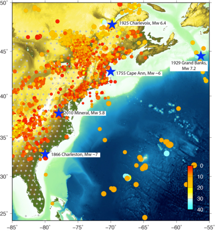
Figure 1. East coast seismicity, 1970-2011. Epicenters from NEIC, LCSN, and CERI catalogs (merged catalogs, no overlap). Historic large magnitude events shown by blue stars. USArray TA stations shown by gray diamonds.
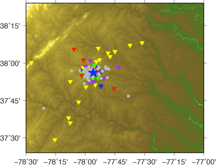
Figure 2. Mineral Earthquake Aftershock deployment. USGS stations in yellow, IRIS stations in red, VA Tech stations in purple, LCSN stations in green, CERI stations in blue. (Alternate includes epicenters in gray from http://www.eas.slu.edu/eqc/eqc_significant/2011_Virginia/aftershock.html).


