

By Susan van der Lee, and Xiaoting Lou - Summer/Fall 2011
In its July 2011 issue, Popular Science ranked EarthScope the “most epic” big science project because of its ambitious scope: Exploration of the deep geologic structure and evolution of an entire continent. A key EarthScope element is the Transportable Array (TA) of 400 seismic stations, on its way to populating over 1600 sites across the US. Each station stays at a site for about 2 years before moving eastwards. Since its start on the West Coast in 2004, the TA has already occupied over 1200 sites and has reached the westernmost of the Great Lakes; in 2013 it will arrive in Washington DC. The high TA station density, data return rate, and data quality allow researchers to image the US mantle structure with unprecedented detail.
North America’s geologic diversity has made it a long-standing favorite target for 3D imaging of its deep structure. Global 3D Earth models from the 1980s documented a strong contrast between the weak, hot mantle beneath the tectonically active western US and the strong, solid mantle beneath the large, stable, cratonic part east of the Rocky Mountain front (RMf). This contrast, incidentally, is the reason why the Aug 23 M5.8 Virginia earthquake was felt at greater distances than we would expect for an equivalent earthquake occurring in the western US. Fine-scale lateral variations in deep structure have been resolved for selected, small areas covered by local seismic networks, such as southern California. Much of what we understand about how continents form and are sustained is based on global studies and a small number of high-resolution local studies. EarthScope’s USArray is bringing the imaging detail from local and regional studies to the broader continental scale, reinforcing as well as challenging our established understanding of continent formation and underlying mantle processes.
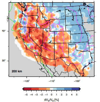
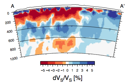
Regional tomographic images based on TA data recorded in the western US (see references below for examples of recent publications) show, for example, details of present and past subduction beneath the western margin and the extent of the Yellowstone plume at unprecedented resolution. Current TA tomography models are mainly derived from P waves. As the TA migrates east, we are folding in new S-wave data, which are more sensitive to structural, compositional and thermal variations than P waves. Figures 1 and 2 present a map view and cross section for preliminary results of a joint inversion of different types of S and surface waves, all sensitive to the same S-velocity structure. For a preliminary inversion, our model is remarkably consistent with previous, less detailed S-velocity models as well as with the abovementioned P-velocity models. For example, the large high S-velocity region in Figure 1 illustrates the thickness of the strong lithosphere of the North-American craton. These high S velocities extend to the Colorado Plateau, which is surrounded on the west, south and east by low-velocity, deformable material. High S velocities are also imaged about 300 km landwards from the trench between the overriding North-American plate and the subducting Gorda and Juan de Fuca plates, two remaining Farallon plate fragments. Figure 2 shows low velocities in the lower mantle beneath Yellowstone and high-velocity fragments of the subducted Farallon plate in the transition zone between 400 and 700 km deep.
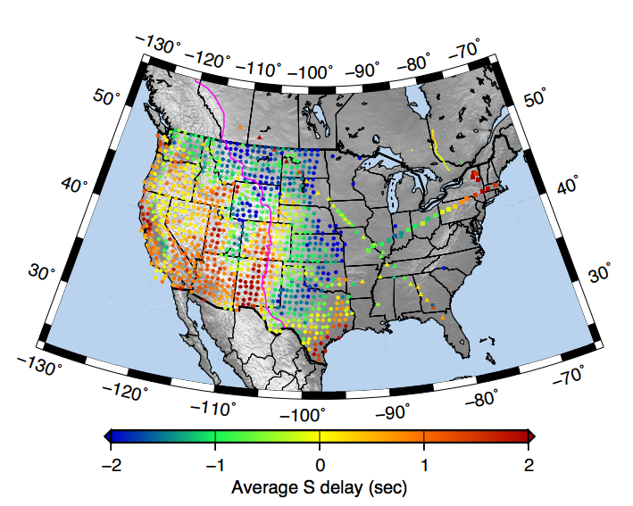
Heterogeneity and complex fine structure were expected in the mantle beneath the mobile western US. Now that the TA is sampling structures east of the RMf in the stable, cratonic part of the US, will we find smaller heterogeneity and less structural complexity? Figure 3 shows average delays of teleseismic S waves for each TA site and stations of select, preceding seismic deployments. The delays east of the RMf have the same range as delays from sites in the western US, implying that the mantle beneath the eastern US is at least as heterogeneous as that west of the Rocky Mountains. Exciting science targets are abundant east of the RMf. Their study will likely lead to significant improvements in understanding continental formation and longevity (“Key Targets for the Future” was also an EarthScope National Meeting session).
For example, the new S-wave data from USArray provide dramatically improved resolving power compared to a continent-scale study in the 1990s (van der Lee and Nolet, 1997) that found (1) low seismic velocities in the mantle transition zone beneath the Paleozoic eastern margin and (2) trailing fragments of the Farallon plate beneath the Cenozoic western US. A followup study with pre-USArray data (Bedle and van der Lee, 2009) suggested these features could be connected through a deep-mantle water cycle, which is possibly working to initiate the subduction of oceanic lithosphere beneath the Atlantic seaboard. New TA data from the eastern margin will have the resolving power to test this hypothetical relation between a deep mantle water cycle and the sustained triggering of subduction zones through time (van der Lee at el., 2008).
Other science questions are targeted using another key component of USArray: the Flexible Array (FA). The FA is used by Principal Investigators at universities to, for example, locally increase resolving power with dense seismic deployments with smaller aperture than a TA swath. FA experiments have been initiated or proposed for a variety of enigmatic continental features east of the Mississippi: Study targets range from the most active seismic zone in the central US (the New Madrid Seismic Zone) to the region with the largest Bouguer gravity anomaly in the US but curiously stable geology (www.earth.northwestern.edu/spree), and cover the transition from Proterozoic (Laurentia) to Paleozoic North America and the effect of Mesozoic rifting on the Paleozoic margin (www.geo.brown.edu/geophysics/SESAME/Site/SESAME.html). Other targets include shallow sedimentary basins, such as the Illinois (www.isgs.uiuc.edu/ education/Train-EarthS.shtml) and Michigan basins, which mysteriously appeared in the middle of a stable continent, and the aforementioned deep, possibly wet upwelling from the transition zone that might be on its way to wreak geologic havoc through triggering the subduction of Mesozoic Atlantic lithosphere.
With the new wealth of data, EarthScope researchers are busy testing hypotheses about how North America came to be the diverse continent that we thought we knew.
References
Bedle, H., and S. van der Lee, S velocity variations beneath North America, J. Geophys. Res., 114, B07308, doi: 10.1029/2008JB005949, 2009.
Bedle, H., and S. van der Lee, Fossil flat-slab subduction beneath the Illinois basin, USA, Tectonophysics, 424(1-2), 53-68, 2006.
van der Lee, S., and A. Frederiksen, Surface wave tomography applied to the North American upper mantle, in Seismic Earth: Array Analysis of Broadband Seismograms, Geophys. Monogr. Ser., vol. 157, eds. A. Levander and G. Nolet, pp. 67-80, AGU, Washington, D.C., 2005.
van der Lee, S., and G. Nolet, Upper mantle S velocity structure of North America, J. Geophys. Res., 102(10), 22,815-22,838, 1997.
van der Lee, S., K. Regenauer-Lieb, S. Jacobsen, and D. Yuen, The role of water in connecting past and future episodes of subduction, Earth Planet. Sci. Lett., 273, 15-27, doi: 10.1016/j. epsl.2008.04.041, 2008.


