By Maureen Long and Vadim Levin - Winter 2014
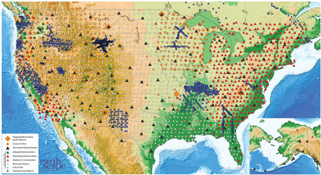
On October 1st 2013 the seismic and magnetotelluric observatory network USArray, which is a key element of the EarthScope project, reached an important milestone – the final Transportable Array (TA) station installation in the contiguous United States. TA stations record seismic waves from earthquakes, as well as mining blasts, meteorite impacts, hurricanes, tornadoes, and even breaking surf along the coasts. Similar to a large telescope scanning the sky, the EarthScope Transportable Array will have completed the first-ever high-resolution “scan” of the contiguous United States by 2015.
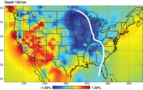
The EarthScope Project aims to build a new level of understanding of the structure and history of the North American continent. Its inter-related scientific goals include: a) understanding the present-day structure and properties of geological features at depth; b) understanding the history of these features; and c) understanding the mechanisms that shape geologic features, form mineral resources, and give rise to natural hazards. Using a variety of geophysical methods researchers can explore Earth’s interior structure (Figure 2) and evaluate basic physical properties of the materials that make up the Earth. By linking the geology and features seen on the Earth’s surface to these new images of the Earth’s interior, the complicated geologic history of the continent can be unraveled. Additionally, comparisons between areas where geological processes are obviously active (such as California and the Pacific Northwest) and areas where they are apparently dormant (such as the mid-continent plains and the Appalachian mountains), provide a way to understand ongoing tectonic processes and reconstruct past events. The USArray network moved from west to east, and has now successfully covered the entire contiguous US and parts of Canada. Data collected have already yielded transformative findings, both anticipated and unforeseen. For example, detailed images of the Juan de Fuca/Farallon slab sinking into the mantle beneath the western part of the continent has inspired new views of the tectonic history of North America. The clear evidence of warm and electrically conductive material trailing west from Yellowstone further supports a hot spot interpretation. The near-circular pattern of upper mantle anisotropy beneath the western US is now defined in fine detail, allowing a more comprehensive assessment of mantle dynamics. Multitudes of small earthquakes have been detected illuminating geological activity of the shallow crust. Among the unexpected findings, one of the most notable and exciting is the phenomenon of the episodic tremor and slip beneath Cascadia.

USArray in the East - Imaging a not-so-passive margin
For a region where tectonic forces last acted nearly 200 million years ago, the eastern margin of North America displays remarkable vigor with rugged topography, substantial earthquakes (e.g., the M=5.8 earthquake in Mineral, VA in August 2011), and even relatively recent (~40 Ma) volcanic activity. The East Coast of the US and Canada is considered a passive (inactive) continental margin. It records two full supercontinent cycles of formation and destruction of mountains linked to the separating and re-assembling of past continents. The geologic signatures of these events are preserved in the rocks of the Appalachians, within the sediments of the coastal plain, and in the deeply buried rocks of the continental mass. By revealing the details of the deep structure beneath the continent and linking them to surface features, the EarthScope project will help address long-standing puzzles in the region,such as the reasons the Appalachian mountains are so high 200 Ma after their formation, and the role pre-existing structures play in controlling subsequent tectonic events. Home to nearly 40% of the North American population, this region is also a locus of significant levels of risk from natural hazards, both abrupt (earthquakes, hurricanes) and gradual (sea level rise).
Looking ahead - The best of EarthScope is yet to come

The great success of EarthScope in the western United States underscores even greater potential for the future. In two years, the main technical goal of EarthScope’s seismic Transportable Array (TA) will be accomplished; observations of seismic waves crossing the North American continent will be obtained every 75 km over its entire mid-section. In addition to the synoptic imaging provided by the TA, more detailed imaging will result from targeted experiments using the Flexible Array (FA), including ongoing and upcoming experiments in eastern North America. FA experiments focus on important individual scientific targets, including the Mississippi Embayment, the New Madrid and Wabash Valley seismic zones, the Appalachian Mountains, and ancient suture zones in the southeastern and northeastern US (extending into the Superior Province of Canada). The eastern margin of the continent also provides a compelling target for other types of investigations such as the magnetotelluric (MT) component of USArray. As the USArray dataset in the lower 48 states is completed, EarthScope scientists anticipate that the resolution of the subsurface structure will improve by nearly an order of magnitude. Figure 2 illustrates this well, with regions already sampled displaying small-scale structure lacking in our “view” further east. A new comprehensive view of the North American continent and the mantle beneath it will most likely challenge the current thinking about the formation and destruction of continents, the longevity of mountain ranges, and the birth and demise of ocean basins. On the practical level, our understanding of where to look for natural resources, how to mitigate seismic hazards, and how high to raise nearshore houses will all be impacted. The key to understanding our societal future may very well lie in our tectonic past.


