

Spring 2012
USArray Status
The Transportable Array (TA) continues to roll eastward across the US. Having crossed the Mississippi River in March 2011, the TA will reach the Atlantic Coast in February 2012. Thus far, over 1300 sites have been commissioned in 31 states. About 800 of these sites were removed after two years of service; however, some 50 stations have been "adopted" and continue to operate with new owners. Data quality and reliability of TA stations remain high as sites are installed in different geologic regions; data availability consistently exceeds 95%. Recent station design enhancements include the use of a new rotomolded vault and the deployment of an atmospheric acoustic sensor package consisting of a high-performance barometer and an infrasound microphone. The Flexible Array (FA) instrument pool continues to be heavily utilized. In early 2011, it furnished its entire supply of Texan seismometers and a considerable number of additional instruments for the Salton Seismic Imaging Project. This experiment, one of EarthScope’s largest, was executed with help from Array Operations Facility staff and numerous student volunteers. The permanent magnetotelluric (MT) observatory continues to telemeter raw data from its seven stations. The transportable MT array completed its multi-year deployment in the northwest quadrant of the US and began operations in the Mid-Continent Rift region. The TA Student Siting Program continues to engage students in EarthScope. Last summer, students identified about 200 sites for future stations across southernmost Canada, the Midwest, and the Southeast. Other outreach activities and products include content development for the Active Earth Monitor in collaboration with the EarthScope National Office and UNAVCO, creation of wave visualization movies, and interaction with local and regional news media. Filmed in summer 2010, the TA, EarthScope and seismic tomography were prominently featured in the National Geographic Channel special "X-Ray Earth," that aired in May.
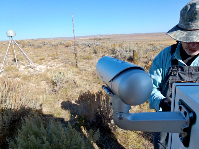
Figure 1: An atmospheric acoustic sensor package (enclosure in the lower right houses the ports for the high performance barometer and an infrasound microphone) installed at a Transportable Array station. The data from these sensors are openly distributed in the same manner as all Transportable Array data. (This work is in collaboration with an NSF MRI-R2 grant to the University of California, San Diego.)
SAFOD Status
Since the completion of SAFOD Phase III drilling, September 2007, scientists at labs around the world have been working on the core retrieved from two actively-creeping fault strands penetrated in the SAFOD borehole. Results from the second round of sample distribution, which included the first large samples of fault core, have yielded at least 14 peer-reviewed papers with an additional 3 currently in press, and multiple papers in the process of being submitted. The third round of sample distribution began in December of 2011, highlighted by the release of the most requested core recovered in SAFOD drilling. Core G27 is from the Southwest Deforming Zone and places sheared serpentine directly adjacent to a 1.5m wide sheared gouge zone. Work is underway to distribute these highly desired samples to scientists who will study mineralogy and chemistry, deformation microstructures, permeability, and other mechanical properties. Recent experimental results have shown that the main zone of active slip is extremely weak, with friction µ < 0.1, and that recovery of friction following slip (so called frictional healing) is extremely slow. Detailed analysis of the core has shown the important role of pressure solution, the presence of past seismic activity, and the role of authigenic clay growth and shear fabric on fault behavior. Publications related to SAFOD, along with other Earthscope related publications can be found at: https://www.earthscope.org/publications/2011
PBO Status - GPS Web Camera Installations Add an Additional Dimension to the PBO Network (December 2011)
In September 2011, Plate Boundary Observatory field engineers installed a web camera at GPS station P101 to support validation tests for snow effects on reflected GPS signals. Previously, web-cameras have been added to a small subset of PBO stations as a cost-savings tool for helicopter operations. However, web cameras are now being used for validation testing for snow studies. The Principal Investigator, Dr. Kristine Larson from the University of Colorado, looks at changes in multipath frequencies to estimate changes in snow depth around the monument. The images generated from the installed web cameras will validate the method by comparing actual snow depths with predicted snow depths derived from PBO GPS data. As part of this validation test, two web cameras will eventually be co-located at GPS stations within the PBO network. Station P101 is installed at Randolph, Utah and P360 is installed at Harriman State Park, Idaho. Stations were selected based on plentiful snowfall, favorable terrain around the monument, and accessibility. The cameras are powered utilizing existing PBO GPS infrastructure and will record images four times a day. The images are downloaded via existing PBO station data communications systems and will be available on the PBO webpage.


