By IRIS - Fall 2013
Ten years ago, the construction of USArray observatories officially began. This followed numerous community meetings, countless hours of meticulous planning, and some healthy skepticism that perhaps USArray was too ambitious to even be possible. However, the USArray observatories have exceeded expectations for the quality and quantity of data delivered and have provided observations of unprecedented scale:
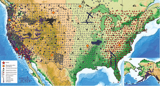
- The Reference Network, designed to provide a long-term reference frame for the Transportable Array, was completed in September 2006. It consists of more than 100 stations at approximately 300-km spacing across the conterminous United States and 10 stations in Alaska. Developed in close collaboration with the USGS to augment the Advanced National Seismic System, USArray installed or upgraded 39 of these stations. To improve the uniformity of the Reference Network coverage, the Transportable Array also installed an additional 20 stations that are operating for the duration of USArray.
- The Transportable Array's network of 400 broadband stations, each about 70 km apart, has slowly rolled across the country from west to east, recording data at each site for about two years. In August 2007, the first 400-station footprint was established, stretching from Canada to Mexico in the westernmost United States. The entire observatory has now occupied more than 1700 temporary sites, including 58 sites in southern Ontario and Quebec. The station design has been relatively consistent from site to site, with some additions and improvements, most notably the inclusion of atmospheric sensors starting in 2009, the introduction of rotomolded vaults, and the use of a water-tight box for electronic components. Identification of nearly 85% of the locations was conducted with assistance from about 150 students from more than 50 universities.
- The Flexible Array, consisting of a pool of portable seismic instruments, was established to support focused investigations requiring higher-resolution images embedded within the context of the Transportable Array. Thus far, more than 20 major PI-driven Flexible Array experiments have been supported. The pool has 326 broadband, 120 short period, and 1700 active source instruments.
- In 2008, a Magnetotelluric backbone observatory was completed with seven stations installed within the United States. Twenty additional systems are in use for Transportable Array deployments with 70-km spacing. During the last seven field seasons, nearly 500 sites have been occupied in the Pacific Northwest and in the Midcontinent Rift. Two magnetotelluric Flexible Array experiments got underway earlier this year.
With more than 54 TB of freely available seismic and magnetotelluric data, USArray observatories have already enabled significant discoveries that have contributed to a better understanding of the structure and evolution of the North American continent. As EarthScope embarks on the next five years, some USArray activities are continuing in the contiguous United States. It is with much anticipation that the Transportable Array will focus on deploying stations on an 85-km grid in Alaska and western Canada. The rugged terrain, the extreme yet fragile environment, and the scarcity of paved roads are among some of the challenges ahead, but with advance planning and ingenuity, all appear surmountable. The scientific community anxiously awaits the arrival of these new data.