
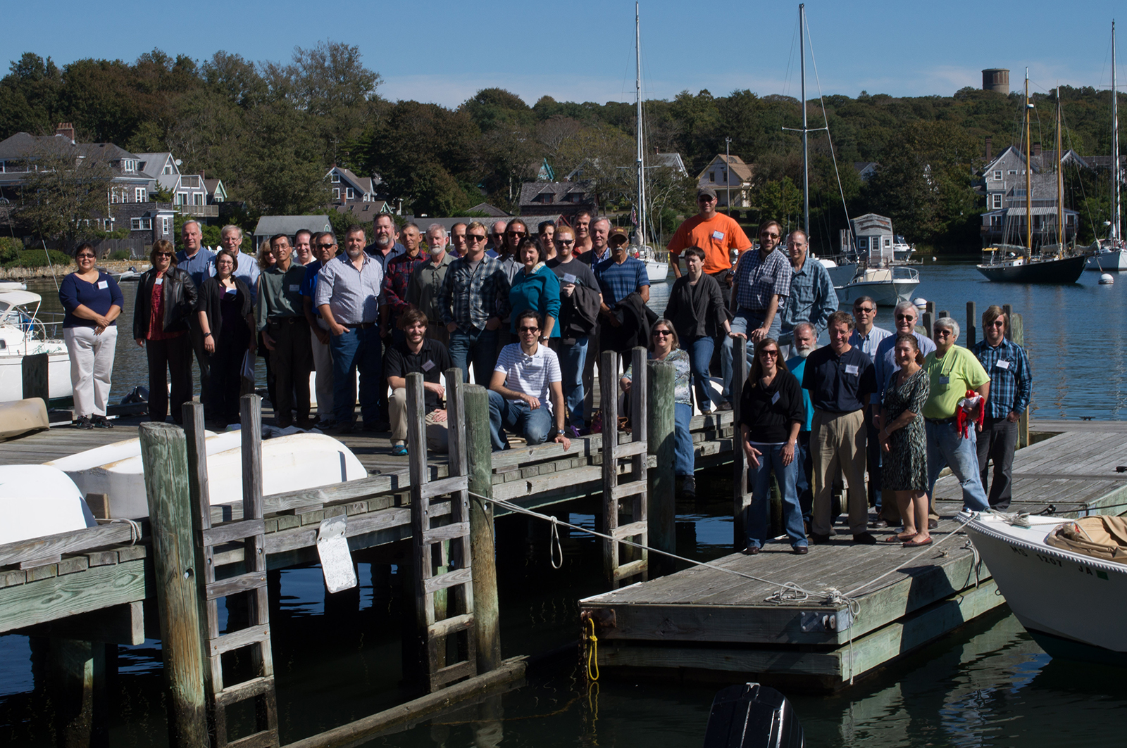
Photo above: On September 30, 2013, the Transportable Array project staff gathered for a science symposium held at Woods Hole Oceanographic Institution to commemorate the completion of Lower 48 TA installations. These are some of the people who made USArray such a success!
by Kasey Aderhold, Robert Busby, Perle Dorr, Andy Frassetto, Justin Sweet, Robert Woodward (all at Incorporated Research Institutions for Seismology, Washington, DC 20005)
The USArray has operated for over 15 years as a community science facility designed to address EarthScope’s goal of understanding the structure and evolution of the North American continent. The three observing components of USArray—the Transportable Array (TA), the Flexible Array (FA), and the Magnetotelluric (MT) Array—have delivered high-quality geophysical observations at an unprecedented continental scale. The TA, FA, and MT programs have been carried out by IRIS in partnership with university staff supported by subawards including, respectively, the University of California-San Diego, New Mexico Institute for Mining and Technology, and Oregon State University. At the outset of USArray, IRIS also worked with the U.S. Geological Survey (USGS) to improve 37 stations in its Advanced National Seismic System network and installed 20 TA stations to improve coverage and form a backbone Reference Network across the Lower 48 states. The success of USArray is primarily due to clear objectives established by the scientific community and the professional execution of the work by IRIS and its partners. In turn, the promise of USArray has been fulfilled many times over by the engagement of scientists from around the world working on these rich datasets. With EarthScope at its end, we take this opportunity to review the scope of these different elements of USArray, highlight some noteworthy or unanticipated scientific outcomes, and reflect on the legacy of these efforts.
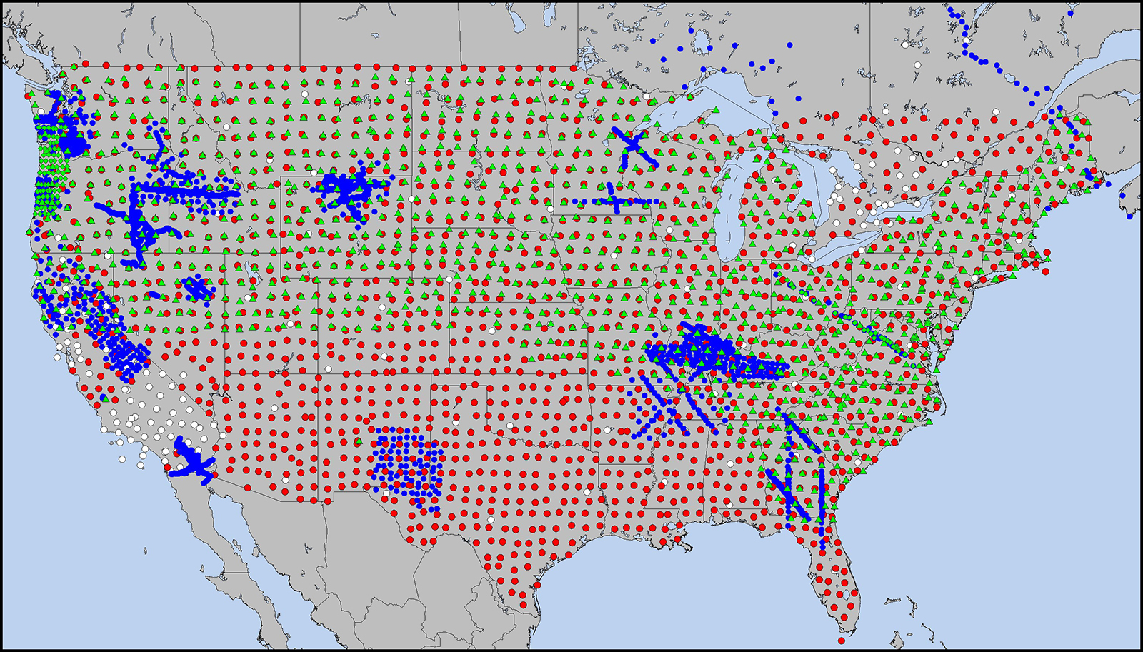
Figure 1: USArray in the Lower 48 U.S. and Southeastern Canada. Transportable Array (TA) stations (red), Flexible Array (FA) stations (blue), and Magnetotelluric (MT) array (green) operated at different scales from 2004–2018. MT stations are subdivided between MT-TA (green triangles) and MT-FA (tight cluster of green diamonds in the Pacific Northwest and dense line across the Mid-Atlantic). Backbone stations (white) were used as part of the TA at its outset and in Canada. Over 200 TA stations have been permanently adopted across the country, and there are active efforts across the federal government to complete the MT-TA across the southern one-third of the U.S.
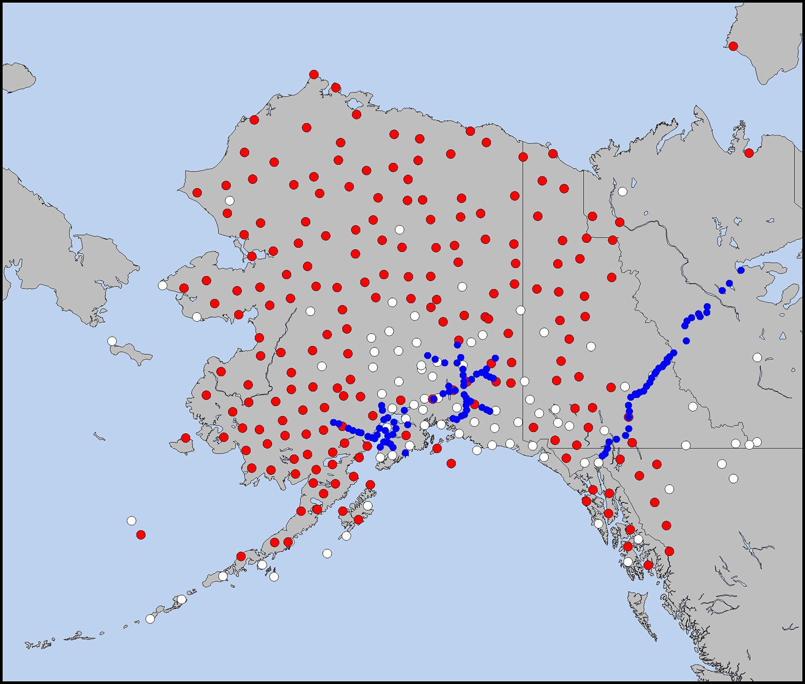
Figure 2: USArray in Alaska and Northwestern Canada. The Transportable Array (TA) (red) and Flexible Array (blue) stations were deployed here between 2014–2017. The TA footprint incorporated many existing high-quality stations (white) in the more populated regions of Alaska. Several TA stations were first deployed in 2011–2013 to evaluate station design concepts, and many TA stations are expected to operate past 2020.
USArray activities were not entirely limited to the United States. Transportable Array stations were deployed in the southernmost parts of Ontario and Quebec provinces in eastern Canada to examine geophysical features that extend across the border and represent a significant seismic hazard in the northeastern U.S. This strategy was leveraged again with the deployment of the TA to Alaska, with 39 of the 196 new seismic stations constructed in the remote regions of the Yukon, Northwest Territories, and British Columbia (Fig. 2). The MT program also encouraged complementary deployments in western Canada that contributed to EarthScope science results. The TA and MT deployments provide a model for future Canadian-led deployments as part of CCArray and EON-ROSE, and have inspired additional international seismic deployments such as TOPO-EUROPE, IberArray, ChinArray, SinoProbe, and the international subduction- zone-focused SZ4D initiative.
Transportable Array
The Transportable Array was envisioned as a footprint of approximately 400 broadband seismometers, spaced at about 70 km, which would roll from west to east across the Lower 48 states and then move on to Alaska. When planned, its design and implementation were unorthodox in the arena of temporary seismic deployments. Each summer, undergraduate students from across the country worked in advance of the coming year’s TA footprint to acquire permits for potential TA sites from private landowners, providing both professional training for the students and engagement with local communities. Installed stations were designed to operate autonomously and continuously, transmitting and archiving their data in real-time. These data were immediately available online to all researchers and closely monitored for quality by the TA staff.
All TA stations used standardized, thoroughly tested designs (vault enclosure, sensors, power, communications) with prefabricated components and clearly defined installation and maintenance procedures. The decision to have all stations transmit data in real-time was aided by the proliferation of cellular service in the Lower 48 states, which allowed the use of cell modems at more than 80% of the TA stations. These various design choices helped to maximize the uptime of stations and create a low-noise environment for the seismometer, improving both the overall quality and quantity of data. The configuration of stations and installation procedures also evolved as the TA team gained experience operating in diverse environments. Early in the operation of the TA, the EarthScope community recognized the scientific potential of recording environmental and atmospheric observations at TA stations and worked with IRIS to obtain funding to add high-resolution infrasound and microbarometric sensors. A report documenting how the Lower 48 TA was built and operated can be found here.
The steady march of Transportable Array seismic stations across the Lower 48 began in May 2004 in Southern California and lasted until the final station was removed from New England in September 2015. Across the U.S. nearly 1,700 TA seismic stations were occupied over this 11-year span, with around 22 months of ground motion data recorded at each site (Fig. 1). The Alaska TA is now operating under similar principles, but with station spacing increased to approximately 85 km and as a single deployment instead of being removed and redeployed like the original TA.
Relocating the TA to Alaska presented major technical and logistical challenges given the remoteness of most of the stations; the long, cold winters in Alaska; and the very limited cellular coverage. To meet these challenges, the TA team utilized a number of technological innovations, including newly available posthole seismic sensors; a helicopter-transportable rock drill to install the posthole sensors; high-capacity, rechargeable lithium-iron-phosphate batteries, like those used in electric cars, to power the stations through the long Alaskan winter; and Broadband Global Area Network Inmarsat satellite systems for data telemetry. The 280 Alaska TA stations (196 operated directly by IRIS) are providing real-time telemetry, continuous operation, and extremely low-noise seismic data (Fig. 2). Some TA stations in Alaska also operate strong motion accelerometers to better observe the strong shaking expected in this seismically active region. Most TA stations also include barometric pressure sensors in addition to the standard complement of seismic and infrasound sensors. Updates on the Alaska TA can be found here.
The Transportable Array deployments have enabled innovative research through a strategy of dense station spacing and large geographic coverage. Most data processing techniques benefit from uniform and high-quality seismic stations. TA data have been used to image Earth’s structure at local, regional, and continental scales in unprecedented detail and increased the detection threshold of small, local earthquakes across the U.S. Researchers have also developed new techniques that leverage the data from the TA, such as teleseismic backprojections to determine the details of rupture processes associated with great earthquakes, and ambient-noise tomography that uses the coherence of microseism surface waves to image the structure of the crust and upper mantle. The presence of the TA was also well-timed to capture and provide invaluable monitoring of an exponential increase in human-induced earthquakes—due mainly to fracking, wastewater injection, and oil and gas mining—in the central and eastern United States over the past 15 years. Hundreds of scientific papers and many theses and dissertations using Transportable Array data have been published, with researchers continuing to probe the nearly 40 Terabytes of TA network data collected so far (see Table 1).
| Network | Stations | Data Archived (Tb) | Data Shipped (Tb) | Unique IP Addresses |
|---|---|---|---|---|
|
Transportable Array |
1,891 | 27.841 | 417.511 | 25,136 |
| Flexible Array* | 4,154 | 14.878 | 73.536 | 4,728 |
| Magnetotelluric Transportable Array** |
1,243 | .022 | .322 | 219 |
Flexible Array
The Flexible Array (FA) component of USArray was a pool of over 2,100 seismometers (including broadband, short-period, and high-frequency sensors) designed to enable high-density, short-term observations of key science targets within the larger footprint of the TA. As the TA traversed the continental U.S. and into Alaska, 32 independent FA deployments were conducted by researchers funded by the National Science Foundation’s EarthScope program. Collectively, these deployments comprise nearly 17,000 individual stations. Unlike the regular station spacing employed by the TA, FA deployments allowed Principal Investigators (PIs) to experiment with a wide variety of deployment geometries (lines, dense arrays, multiple arrays, etc.) tailored to their particular scientific targets. These scientific targets were as diverse and varied as the FA experiments designed to capture them, and included: depth extent of plate boundary faults, magma chamber dimensions beneath active volcanoes, deep structure of sedimentary basins and mountain belts, ancient orogens, rift systems, continental sutures, subduction zone processes, and the structure and magmatic plumbing of continental rifts. Combined with coordinated geological, geochemical, and geodetic studies, the Flexible Array advanced our understanding of local- and regional-scale processes that have and will continue to drive the evolution of the North American continent. Although FA experiment datasets (totaling about 15TB) were available only to project-specific researchers for the first two years after data collection, most are now openly available for follow-up analyses.
Magnetotelluric Transportable Array
The USArray magnetotelluric (MT) program was designed to complement the seismic components of EarthScope at similar scales. Its centerpiece was a continental-scale survey with MT instruments deployed in temporary grids with approximately 70 km spacing to observe the ambient magnetic and electric fields of the Earth. Unlike TA and many FA stations, MT stations only needed to be deployed for a few weeks to complete their observations. These stations make point measurements of the conductivity of underlying rock in the crust and upper mantle. This array of MT stations began deployment in the Pacific Northwest, before hopping to the Midwest, covering the entire Eastern seaboard, and finally connecting the two footprints across the Great Plains, totaling 1,162 stations (Fig. 1), along with dozens of additional stations contributed from other operators, including the USGS. These observations now form a continuous 3D view of the conductivity structure of the northern two-thirds of the U.S. In addition, the program supported several PI-led surveys of more localized geologic targets, including the northern Cascadia forearc, Mount St. Helens, and the Appalachian Mountains. The observations from these deployments have allowed researchers to map the presence of melts and other fluids in the crust and upper mantle across North America, including prominent and enigmatic systems such as the Yellowstone Caldera. In addition, MT data play a unique role in protecting against space weather hazards, showing where power and pipeline infrastructure is most susceptible to geomagnetically-induced currents by revealing the relative electrical resistivity of basement rock beneath utility grids.
Legacy of USArray
USArray was the most ambitious and challenging geophysical experiment ever attempted in the United States. The unqualified success of USArray is a testimony to the professionalism and hard work of the TA staff and our university partners. One legacy of the Transportable Array is the over 200 stations adopted in the Lower 48 states now operated by USGS, regional seismic networks, and universities. The Alaska TA will operate through 2020 or 2021, and 43 stations are already funded for long-term operation by the Alaska Earthquake Center. Additional adoptions are being discussed with several other stakeholders. The most impressive legacy of USArray is undoubtedly the nearly 43 Tb of seismic and magnetotelluric data (Table 1) now archived at the IRIS Data Management Center and the hundreds of papers that have already been published using these data. In the years and decades to come, this unique and rich dataset will continue to be mined by countless researchers to test new scientific hypotheses, develop innovative methods of data analysis, and gain an improved understanding of the processes that shape our dynamic planet.
To stay informed on developments with IRIS, visit the website.


