

By Dr.Hersh Gilbert - Fall 2012
Do high mountains possess thick roots of low-density crust that keep them a"oat in the denser mantle, or do zones of low-density mantle provide the necessary buoyancy for high peaks to remain elevated? The former case predicts that areas of thick and thin crust would correlate with areas of high and low elevations whereas no such correlation would be expected in the latter. Active research by seismologists using EarthScope data seeks to re!ne the answers to these questions and other fundamental geologic concepts. The long history of deformation and tectonism within North America has created a diverse landscape comprised of expansive plains, mountain ranges, and elevated plateaus making it an ideal locale to study continental evolution. Improving our understanding of the evolution of the various tectonic regions across North America requires well-resolved observations of crustal thickness. To understand the role played by preexisting features in modifying crustal structure it is necessary to determine the structure of the crust within and across the boundaries of crustal blocks, or terranes, that accreted together to form North America. Further studying crustal structures within and surrounding tectonic provinces can illustrate the crustal response to speci!c tectonic events.
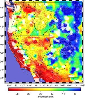
The extensive, dense, and nearly regular sampling of the USArray Transportable Array (TA) facilitates investigating structures across boundaries throughout the continent as the area sampled by the array expands. This sampling allows investigations across terrane boundaries and disparate tectonic environments in a single framework, enabling direct comparisons of features from different regions. Results from analyzing TA data reveal that the crust in the western portion of the United States varies in thickness from less than 30 km to more than 50 km (Figure 1). The thinnest crust lies in the southern Basin and Range in southwest Arizona and the thickest crust lies in the Rocky Mountains in Colorado. Variable crustal thicknesses characterize most of the major tectonic provinces in the western United States including both the Rocky Mountains and Basin and Range. Some changes in crustal structure coincide with terrane boundaries, yet other portions of these boundaries are not associated with observed crustal structures. While thick crust underlies some areas of high elevation, other elevated areas possess thinner crust. Therefore no simple correlation appears between crustal thickness and surface elevation. This observation suggests that variations in both mantle density and crustal thickness support surface elevations.
A continuous image of crustal structure of North America from its tectonically active western margin to its more stable eastern coast illustrates how a stable craton forms from disparate terranes that amalgamated together during multiple episodes of accretion (Figure 2). Over recent geologic history the central and eastern portions of North America have been tectonically quiet compared to the western portion of North America. Still, similar questions about continental evolution need to be addressed to better understand how the central portion of the continent developed. Thin layers of Paleozoic strata overlie crystalline basement across much of the interior continental platform of North America, hiding the nature and location of sutures between Proterozic terranes. Boundaries between terranes in the central and eastern parts of the United States therefore need to be investigated seismically. This research will illuminate whether differences between terranes persisted following accretion or if the process of “cratonization” removed any differences that existed.
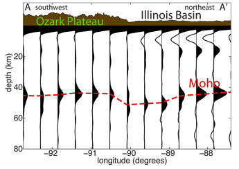
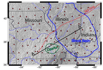
The sampling of the TA through the central portion of North America is providing some of the initial detailed images of the upper mantle of the cratonic interior of this continent. Investigating structures within the lithosphere will also help identify processes that drive uplift and subsidence of intracratonic domes and basins. The thinner crust observed within the Ozark Plateau than beneath the western portion of the Illinois Basin suggests that buoyant mantle and dense lower crust may play a role in keeping the plateau high and basin low (Figure 3). This comprehensive view of the crust of North America provided by the Transportable Array allows us to see that both the crust and mantle contribute to surface elevations throughout the continent.


