

The RLAP GPS site is located in northwestern Tennessee, on the northern end of Reelfoot Lake. Photo courtesy of UNAVCO.
By Beth Bartel and Beth Grassi
Science is all about solving mysteries. So when there are earthquakes happening in places it seems they shouldn’t, we want to know why. In the interior of North America, far from any major plate boundaries, large earthquakes have shaken multi-state regions. The most famous is not a single earthquake but a series of four earthquakes, all over magnitude 7, in the short span of three months from December 1811 to February 1812. These earthquakes occurred in what is now called the New Madrid Seismic Zone, stretching from Illinois to Arkansas, and were felt all the way to Washington, D.C. Why do these earthquakes happen? Will they happen again?
High-precision GPS, like that in the EarthScope Plate Boundary Observatory, plays a critical role in attempting to answer these questions. Earthquakes happen as the result of applied stress and accumulated strain, when the earth’s crust is squished, squeezed, pulled, or shifted by forces within it until it reaches a breaking point. GPS is a tool that can measure how much and where the mid-continent is changing shape, possibly building up to a major rupture.
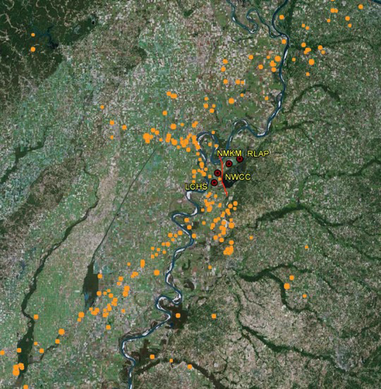
Four GPS sites (red circles) are situated near the Reelfoot Fault. This fault was active during the 1811 earthquakes. These GPS sites help in monitoring the deformation magnitudes and styles at this important fault. The orange dots show the locations of earthquakes that occurred between 1973 and 2013. Photo courtesy of UNAVCO.
The answers aren’t straightforward. Station RLAP, in northwestern Tennessee, has been measuring the motion of the midcontinent for more than 20 years. RLAP alone won’t lend much insight to the problem, but it is one of 14 stations in the GAMA network, a network that precedes the Plate Boundary Observatory (PBO) and has been incorporated into the PBO data flow. RLAP and its neighbors have been under scrutiny for a long time, by multiple research groups, with varying results. In one initial study, researchers’ calculations indicated high relative motion of stations within the network, suggesting the region was changing shape on the scale of the Pacific plate subduction zone. Other researchers were not able to repeat those results, however, instead calculating much smaller motion, close to zero. The seemingly large initial estimates of motion were potentially the result of measurement error created by the type of GPS station. The ground in the region is made up of poorly consolidated sediments deposited by the Mississippi River. The initial instrument monuments, designed with a single post, likely were not as stable in that setting when compared to newer monuments with four deep bracing legs in addition to a central post. (“Monument” is the official term for the base that anchors the GPS instrument.) With improved measurements from the newer monuments, some researchers postulated that the region was not changing shape at all. But if that was the case, what is causing the earthquakes? Researchers now believe that rates of motion are very low—but not zero. Any motion, even very small motion, can build up over a long time and eventually produce a large earthquake.
To understand why the earthquakes are happening where they are, and what is causing the motion, we might look to failed midcontinent rifts, where the earth began to pull apart in the past. The earthquakes may result from old faults associated with the Reelfoot rift, a rift that began to open around 750 million years ago but stopped. Other possible factors, however, have to do with other parts of the midcontinent’s past and present: A heavy tongue of ice from the last glaciation reached the edge of the Mississippi embayment, and the ground may still be rising up in response to the melting of that load. Alternatively, the region may be stressed by other, current factors, such as ground and surface water. Regardless of the cause, GPS stations in the midcontinent will continue to measure motions large and small, to help us understand the forces shaping the region—and where the greatest hazards lie.
For more on RLAP, visit the PBO GPS Spotlight page or the UNAVCO RLAP station page.


