
by Gail McCormick - Winter 2017
As GPS technology has become more accurate and efficient, so too have its unintended uses. Originally designed for positioning, navigation, and timing in the 1960s, GPS has since been co-opted for commerce and recreation—from tracking cargo and smartphones to geocaching and location-based social networking. It has also been adopted by Earth scientists to measure changes in the environment, such as soil moisture, vegetation growth, lake-ice thickness, and snow depth. Now, the large network of GPS instruments included in the Plate Boundary Observatory (PBO), are being used to measure snow depth and to potentially improve existing snow forecasting systems.
Accurately measuring and forecasting snow depth is increasingly valuable in our changing world because snow melt factors into predictions of water flow and availability. Recent years have seen reduced snowfall and earlier snow melts in many regions worldwide, so accurate monitoring is critical, especially in places like the western U.S., where up to 80 percent of water resources originates from snow melt.
“Snow forecasting and monitoring crucial for water resource management,” says Dr. Karen Boniface, a scientific officer at the Joint Research Centre of the European Commission in Italy. She highlights the significance of snow forecasts in anticipating potential droughts that can impact agriculture, industry, energy production, and the economy. For Boniface and her colleagues, the GPS network erected by the PBO provides a dense array with which to evaluate the accuracy and ultimately fill in the blanks of our existing national snow-depth network.
Assessing Existing Methods
The National Weather Service estimates snow depths using a complex modeling and data assimilation system called SNODAS (Snow Data Assimilation). SNODAS incorporates data from as many ground, satellite, and airborne monitoring efforts as possible in the conterminous U.S. This includes manual and ultrasonic automatic sensor measurements from the National Water and Climate Center Snow Telemetry (SNOTEL) survey, as well as other meteorological data such as solar radiation and cloud cover. SNODAS estimates snow cover every hour at a resolution of 1 km, making it the most comprehensive and detailed snow data set in the country. SNODAS synthesizes a huge amount of information and has impressive resolution, but it isn’t perfect, especially in areas where automatic SNOTEL sensors are not present. A GPS network may offer the opportunity to close some of the gaps.
GPS can measure snow depth because accumulating snow effectively changes the height of the ground. GPS satellites emit signals that are picked up by antennas at or near Earth’s surface. The majority of the PBO antennas are approximately two meters above the ground. But sometimes signals bounce off the ground before they are received, and mixing these “direct” and “indirect” signals produces an interference pattern that shows up in the signal-to-noise ratio (SNR). By comparing differences in these SNR interferences patterns throughout the year, researchers can infer changes in height of the GPS antenna above the reflecting surface (the ground) due to accumulating or melting snow—in other words, snow depth. A GPS instrument monitors an area of 1,000 square meters around the antenna and in most cases provides accurate snow depth measurements on the order of a centimeter, according to Boniface.
"Because GPS was not being used within the SNODAS system, we had an opportunity to assess how well the model was doing across the western U.S.” says Dr. John Braun, a researcher at the University Corporation for Atmospheric Research (UCAR) who contributed to the project. “It was a unique chance to compare two data sets that span a large geographic region."
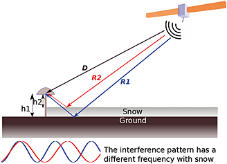 Illustration: A GPS antenna picks up satellite signals either directly (black line) or indirectly after they bounce off the ground (red and blue lines). Differences in the ground height caused by snowfall changes how the indirect signals are received. (image: Boniface et al, 2015, used with permission)
That’s where the PBO comes in. The network, designed originally to study the 3D strain field arising from active plate boundary deformation, contains more than 1,000 recording stations across the western U.S. and Alaska. Each unit contains GPS, seismic, and other geodetic instruments that transmit data in real time. This instrumental combination has proven useful for a range of geoscience-related research projects.
Researchers have used GPS to calculate snow depth in the past, but typically only for a few days or at a single site. One study monitored snow depth at six sites over two years using GPS, but the scale of Boniface’s study is unprecedented. She and her team recorded daily snow measurements from 100 sites in the western U.S. over three years. “It’s the first study that uses so much data for snow-depth measurements,” she says.
For many of their sites, Boniface and colleagues also collected manual snow measurements, used time-lapse photography to measure snow depth relative to marked poles, and compared directly to automatic SNOTEL sensors to assess why there were differences between GPS measurements and SNODAS estimates. The results of this comparison were published in the May 2015 issue of Hydrological Processes.
Comparing SNODAS and GPS
At most of the sites, snow-depth measurements from GPS observations and from SNODAS agreed within centimeters. At the remaining sites, measurements were off, in some cases by up to a meter. These differences may have been due to errors in measurement by GPS or SNODAS; the errors were even clearer when measurements from one or both of the methods didn’t match up with those made by hand or the time-lapse photography.
Differences between SNODAS and GPS were greatest in areas where vegetation varied around the instruments. SNOTEL sensors are typically placed in small clearings in forested areas, while GPS units are placed at lower elevations in open areas away from trees. Without trees to block wind and solar radiation, the open areas around GPS units may in fact have less snow. SNODAS creates a snow-depth estimate for a 1 km x 1 km square, and it may not produce a representative average over such a large area where inconsistent vegetation—or inconsistent topography—causes variation in snow depth. Because GPS operates at a finer scale (one GPS unit covers about 0.1 percent of a SNODAS grid square), this variation is less of a problem. An obvious solution to the SNODAS limitation would be to incorporate the finer-resolution GPS data. Incorporating GPS into the SNODAS model may overcome limitations of both methods, improving snow-depth estimates, especially in areas with variable vegetation or topography or where SNOTEL sensors are lacking.
Evolving Technology
“This study was an introduction of what GPS can bring to the SNODAS assimilation system,” Boniface says, but she admits that more work needs to be done. Next, researchers will test whether adding GPS data to SNODAS actually improves snow-depth estimates.
Although the SNODAS model is limited to the U.S., snow-depth measurements could be made in other regions with Global Navigation Satellite System (GNSS) receivers. Permanent arrays of GNSS antennas are deployed across Europe, Asia, and South America and could be used to measure snow depth. However, they are not ubiquitous. “The primary issue limiting a broader application of these new techniques is the locations of the antennas,” notes Braun.
Another potential limitation lies with the satellites currently orbiting the Earth—they may not be able to “see” all regions well, especially in places where obstacles like mountains or tall buildings block GPS signals. In theory, new GNSS satellite constellations, or networks, across the world could complement the U.S. constellation (GPS), improving precision and data availability. However, satellites in other GNSS constellations, like those being deployed in Asia and Europe (GALILEO) do not have repeating tracks, meaning they do not cover the same ground every 24-hour period like GPS satellites. This is integral when snow depth, so additional research is necessary to utilize other GNSS constellations for this purpose.
Improvements in GNSS receivers and satellite constellations may be key to monitoring and forecasting snow in the future. Snow covers 46 million square km of Earth’s surface every year, but this number changes yearly and will become increasingly unpredictable. Harnessing new and evolving technologies like GPS, and existing infrastructure like the PBO, will be critical to understanding and responding to our changing world.
Find more information on PBO H2O Data Portal website
NSF-related Funding Sources: NSF award 0935728
EarthScope Affiliations: UNAVCO - PBO
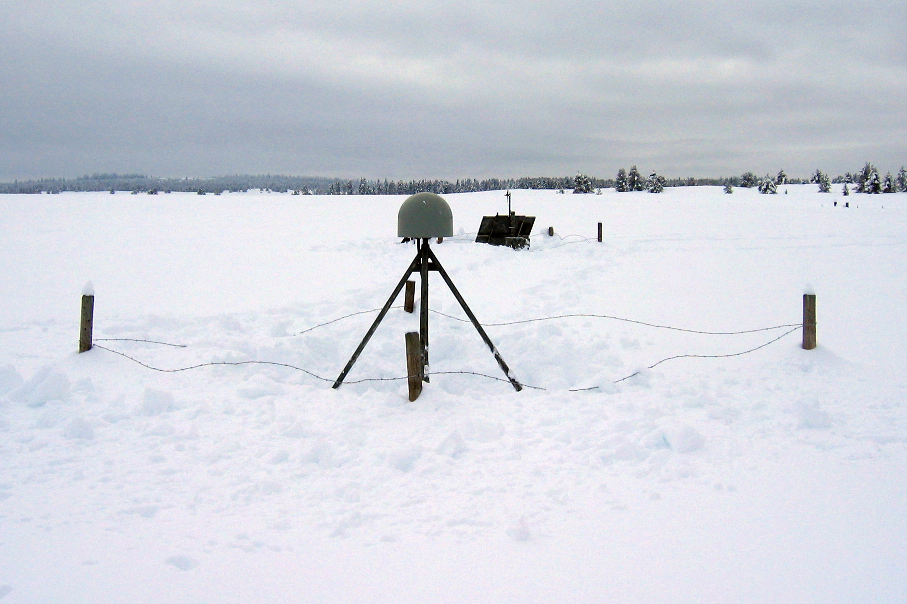
Top Image : PBO monument P360 uses GPS technology to monitor snow depth in Island Park, Idaho. This station, powered by a solar panel, is one of 100 used by researchers to measure snow depth using GPS. (Photo Credit : UNAVCO)


