

Max Enders - Spring 2012
When UNAVCO set about building the Earthscope Plate Boundary Observatory (PBO) no challenge was nearly as daunting as the prospect of installing the network of 140 GPS stations in the state of Alaska. The largest state in the Union, Alaska is well known for its rugged terrain, dangerous animals, and numerous other natural hazards. It is also considered one of the most interesting places on the planet for geologists and geophysicists. Within the area instrumented by the Plate Boundary Observatory Project, there are active volcanoes, a subduction zone that has produced some of the largest historical earthquakes and examples of nearly every other tectonic process. This makes it a natural laboratory without parallel that with further study, can possibly lead to answers to many fundamental geological and geophysical questions.
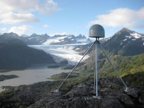
Plans for the Plate Boundary Observatory network called for installing stations throughout the state from the Southeast to the North Slope and all the way out to the far western Aleutian Islands. For perspective, it is interesting to note that the Alaska network has both the most western station in the PBO network, AB21 Adak Island (174 W longitude), and the most eastern station in the network, AC66 Amchitka Island (179 E longitude)! The majority of the stations in the network are located far from the few roads in the state, high on ridge tops, or on the $anks of active volcanoes (Figure 4). Travelling over land either by vehicle or on foot to the station locations was impractical for the most part, so it was necessary to use airplanes or helicopters for access. Though physical access to station locations was a major issue for PBO, it was just one of many challenges engineers would have to face and overcome in order for the project to succeed. UNAVCO engineers in Alaska faced a challenging lack of communications infrastructure to get data from remote stations to the data processing facilities in the Lower 48. Things that are taken for granted in the continental U.S., such as cellular telephone networks, wired internet connections, and even dial-up internet access, are all but non-existent in Alaska. Instead, PBO used a combination of radio links from remote stations to more developed areas where internet access was available. In areas where radio networks were not feasible, satellite internet connections provided data telemetry. Powering remote stations was also uniquely challenging in Alaska, since during the winter there is little sunlight for solar power. In the Lower 48 where sunlight is abundant during both the winter and the summer, most stations could be powered by solar arrays with as few as four batteries for energy storage.In Alaska, it was necessary to install 24 batteries, each battery weighing approximately 70lbs, at the majority of stations. With this much power storage, the network was able to collect data uninterrupted during the dark winter months. Despite these and other challenges, PBO engineers were able to complete the construction of all 140 stations in Alaska on time and under budget.
While every installation in Alaska was uniquely challenging, one particular example of the many logistical, technical, physical, and mental challenges faced by UNAVCO crews in Alaska stands out: the installation of the Unimak Island network of GPS, Tiltmeter, and Communications stations. More than 600 miles west of Anchorage, AK lies Unimak Island, the most eastern of the Aleutian Islands, stretching approximately 70 miles long and 30 miles across, making it slightly larger than the state of Rhode Island. It is home to four active volcanoes, several hundred hungry grizzly bears, roving packs of wolves, herds of caribou, and about 30 very hearty humans living in the town of False Pass at the eastern end of the Island. Surrounded by the Bering Sea to the north and the Pacific Ocean to the south, Unimak Island is well known as having some of the worst weather in the Aleutian Island chain. Storms often batter the island from both sides for days on end with hurricane force winds and torrential rains. In this most inhospitable of environments, it was PBO’s task to install a network of thirteen GPS stations and eight tiltmeters on three of the most active volcanoes on the island. This instrumentation would give scientists the ability to conduct research that would help understand the processes that lead to the extreme volcanic activity in this part of the world. This network of instrumentation would also augment the existing seismic network on the volcano and give geologists a more accurate picture of what was going on under the surface. With this new information, scientists are better able to monitor the volcanoes and provide more accurate and timely warnings in the event of an eruption. A critical network of stations such as this one required a robust and reliable communications pathway. Needless to say, there was no communications infrastructure on Unimak Island, and PBO engineers had to construct a series of communications relays. These relays linked stations on the west side of the island to a communication hub located in Akutan, and stations on the east side of the island to Cold Bay. These networks were designed to be robust enough to stream high rate data from all stations to better help scientists evaluate hazards associated with the volcanoes.
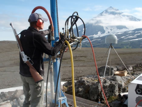
The schedule to complete the installation of the GPS and Communications network was ambitious even by PBO standards, allowing for just three weeks for all stations and communications infrastructure to be installed. The field crew consisted of five UNAVCO engineers and an Alaska Volcano Observatory geologist. The field crew was supported by two helicopters and a research vessel. In addition to working from the research vessel, a base of operations was established in False Pass on the east end of the island and an emergency camp, complete with electrified bear fence, was constructed on the western end of the Island at Cape Sarichef. This gave crews several places to stay if they got stranded on land, unable to return to the boat due to weather. The quantity of materials and supplies needed for these installations was quite impressive. 13 electronics enclosure huts, a helicopter portable drill rig, 2300 pounds of batteries, 6000 gallons of jet fuel, and several thousand pounds of steel had to be transported from Anchorage to False Pass. In addition to utilizing every bit of cargo space on the 110’ research vessel, two 40-foot containers filled with installation supplies were mobilized from Anchorage to False Pass via the Alaska State Ferry. Thanks to lots of hard work in the years and months leading up to these installations, this project was completed without any major delays. Field crews were able to take full advantage of the few good weather days they had, completing all installations with time to spare in little over 18 days.
Currently, UNAVCO maintains and operates the Plate Boundary Observatory network in Alaska and continues work to improve network operation to better serve the scientific community. We continue to work with our partners at the USGS, University Alaska Fairbanks, the Alaska Earthquake Information Center, the West Coast Tsunami Warning Center and many others to better understand our dynamic earth. Stay tuned for more stories in future InSights editions!


