

By Cascadia Initiative Expedition Team (CIET)[http://cascadia.uoregon.edu] - Winter 2015
The increasing public awareness that the Cascadia subduction zone in the Pacific Northwest is capable of great earthquakes (M9 and greater) motivates the Cascadia Initiative (CI), an ambitious onshore/offshore seismic and geodetic experiment that takes advantage of an Amphibious Array to study questions ranging from megathrust earthquakes, to volcanic arc structure, to the formation, deformation and hydration of the Juan De Fuca and Gorda plates.
Two aspects of the CI are novel and changing both practices and capabilities within the ocean sciences community. First, the CI is a community-based experiment, meaning that the scientific community vets its objectives, experimental design and logistical implementation and that all resulting data are publically available. Secondly, the CI is deploying a new generation of ocean bottom seismometers (OBSs) that are designed to withstand a direct hit by bottom trawling fisheries and that are equipped with sensors shielded from ocean bottom currents, thereby opening up the shallow marine environment (<1000 m) for more routine geophysical investigations.
Addressing the diversity of the CI science objectives requires an ambitious, plate-scale seismic experiment, one that encompasses the onshore and offshore components of the Cascadia subduction zone as well as the underthrusting Juan de Fuca plate (Figure 1). An NSF-supported, community workshop convened in Portland, Oregon in October 2010 [http://www.oceanleadership.org/wp-content/uploads/2010/05/CI_Workshop-Report_Final.pdf] concluded that the OBS component of the CI should comprise both a plate-scale deployment of OBSs that replicated the 70 km spacing and 18-month duration of the EarthScope transportable array and a tighter array along the subduction zone including several focused experiments at key sites. To achieve this coverage, the CI leverages seismic instrumentation from a number of international facilities, regional monitoring networks and experiments proposed by Principal Investigators.
The benefits of a community experiment are several: The primary benefit is that the community can do experiments that would be unaffordable otherwise given the expense of working in the oceans. Large-scale experiments can only move forward by establishing community buy-in. This includes defining the science objectives, the instrumental capabilities, the availability of data and metadata, and an overall plan for an integrated analysis and synthesis of results. Second, a policy of open-data access increases the breadth of inquiry and types of methodologies applied to the resulting data, thereby increasing the data’s value. To date, over 500 unique users, at over 300 unique institutions, in 25 different countries, have downloaded over 20 TB of CI OBS data from the IRIS DMC. That so many users are downloading CI OBS data ensures that there is wider use of the data, thereby enhancing the scientific return and making the overall experiment cost effective. Lastly, the CI is having a profound influence on the community that uses ocean-bottom seismometer data, particularly early career scientists. The Cascadia Initiative Expedition Team’s Apply-to-Sail program has taken over 100 early career scientists to sea, including undergraduates, graduate students and post-docs.
The sea-going component of the CI is in its final year of a four-year deployment/recovery cycle. Data from the first 3 years of the CI are openly available at the IRIS DMC. Currently, scientists from a wide range of disciplines — including solid earth geophysics, physical oceanography, ocean engineering, and marine biology — are analyzing CI data. These studies are providing new insights into seismicity of the Cascadia subduction zone, mantle flow and anomalous structures both onshore and offshore of Cascadia, the causes of microseismic noise, improvements in the design of ocean bottom seismometers, and the migratory habits of baleen whales.
The new technology comprising the Amphibious Array Facility combined with the ambitious scale of the Cascadia Initiative constitutes a sea change in studies of subduction zones and continental margins in general. The success and enthusiasm for collaborative efforts between the terrestrial and marine seismology communities bodes well for future interdisciplinary and interdivisional cooperation at NSF.
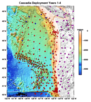
Locations of ocean bottom and onshore seismometers deployed during the Cascadia Initiative (CI). The amphibious array covers the entirety of the Juan de Fuca plate and the Cascadia Subduction Zone. Red circles indicate CI OBSs; brown circles indicate OBSs of PI-driven experiments complementing the CI design; blue squares are permanent seismometers attached to cabled observatories of Neptune Canada and the Ocean observatories initiative. Purple circles are onshore seismometers.
More pictures are available in the PDF version: /sites/default/files/2016-10/inSights_Winter2015.pdf


