
by Sara Tewksbury - NSF # EAR-1331084, EAR-1614323, EAR-1614855 | Summer 2017
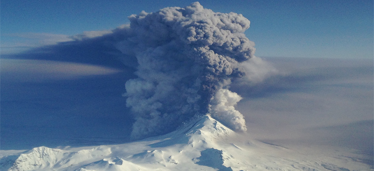
When Alaska’s Pavlof volcano erupted in March 2016, the resulting plume spewed ash skyward for almost 40 hours, disrupting more than 100 commercial flights. At the Alaska Volcano Observatory, researchers considered the eruption over when seismic activity had ceased. They discovered soon that the volcano’s ash plume continued for hours. EarthScope’s Transportable Array (TA) stations captured the eruptive activity—the first volcanic eruption recorded by EarthScope since the first TA deployments in 2004. Data from the array also helped to create a detailed chronology of the 40 hours of sustained ash plume, showing that the ash plume persisted post-eruption and reached up to over 9000 meters (30,000 feet).
“From a geophysicist’s point of view, we thought the eruption was over, but then we got some images and there was still a pretty significant ash plume. This was a bit of a surprise,” recalls David Fee, Research Associate Professor at the University of Alaska Fairbanks (UAF) Geophysical Institute and Alaska Volcano Observatory, who is lead author of a paper on using sound and seismic waves to determine the height of a volcanic ash plume, published in Science.
In Fee’s lab, researchers study how infrasound, which travels at a frequency below what the human ear can register, can be used in conjunction with seismicity to tell us more about volcanic eruptions. The disjointed signals from Pavlof—dropoff of infrasound and seismic waves despite ongoing plume activity—gave Fee and his colleagues the opportunity to explore how the eruption and the plume matched with the signals they had measured. “That was kind of the start of this idea, this time dependence of the relationship of the seismic and infrasound with plume heights.”
When a volcano erupts, magma forces its way out of the volcanic vent with tremor-inducing force, sending energy through the ground as seismic waves and into the air as infrasound waves. Infrasound sensors are mounted to most TA stations, and record information provided by sound wavelengths typically only heard by animals such as whales and elephants.
The relationship between the seismic and infrasound signals with the ash plume reminded one of Fee’s colleagues, Matthew Haney of the U.S. Geological Survey in Anchorage, of a similar event that can occur following flooding and erosion in rivers. This connection led Fee to probe the idea that erosion of the volcanic vent could account for the drop in seismic activity during the eruption.
Fortuitous circumstances
Studying the relationship between seismicity and volcanic eruptions was a topic that Fee’s lab and colleagues had previously thought about. The coincidence of the Pavlof eruption, the TA deployment in Alaska, and a webcam in nearby Cold Bay that was focused on the volcano, provided the ideal setup to capture the ash plume. The camera is part of a vast network that monitors the area for the Federal Aviation Administration, and it snaps a shot every 10 minutes. These pictures, along with satellite images, allowed researchers to infer the plume heights with an estimated accuracy of 300 meters (984 feet). A plume’s height is rarely measured in this detail, since many eruptions are not directly observed. Pavlof’s 9144 m (30,000 ft) -high ash plume was tiny compared with the largest observed (Mt. Pinatubo measured in at 45 km, or 147,500 ft, high), but it lay directly in the path of air traffic.
“We try to use all of the available technologies we have to understand the eruption and to know where the ash is, how much ash is coming out, and when the eruption starts and stops,” Fee said.
Satellite and webcam images, and seismic and infrasound data from multiple networks, were compared to determine the time-dependent relationship between the seismic and infrasound data and the plume height.
Capturing Pavlof’s eroding rim
After a major storm, the rushing water carves a river channel wider and deeper. Similarly, a volcanic eruption can erode the volcanic edifice. Such erosive events are picked up by geophysical instruments. Fee and his colleagues looked at a few studies, including this one by researchers at the Department of Earth and Planetary Sciences, UC Santa Cruz, to learn more about the correlation between seismicity and erosion in rivers. The researchers in this study found that storm events in rivers can be observed seismically. The paper explains how the transport of sediment during storm events creating a hysteresis effect, which is when a physical property lags behind the effect causing it.
“A volcanic conduit and riverbed both consist of compacted, solid material. As an energetic flow, such as an eruption or a flood, passes by it will erode this compacted material and create significant seismicity (and potentially infrasound). Once the energetic flow starts to decrease, the solid material has already been sufficiently eroded and the seismic and infrasonic source changes," Fee said.
Fee and his colleagues found a similar pattern between the volcanic tremor and plume height in their study of the Pavlof eruption. The plume height remained high even after the volcanic tremor decreased significantly. They concluded that the high levels of seismic and infrasound activity correlated with erosion of the volcanic vent, and the forceful exit of the lava and gas widened or eroded the vent simultaneously with heightened seismic and infrasound activity. They inferred that eventually the volcanic flow decouples with the wide vent, causing less interaction between the volcanic flow and the crater walls, thus lowering the infrasound and seismic noise.
Aerial images taken following the eruption showed a crater 130 m wide by 110 m deep at the summit of Pavlof volcano, where there had been no well-defined crater before.
Fee and his colleagues plan to continue their work by looking for records of previous eruptions that may fit the Pavlof model. With the ability to record infrasound data from the recently deployed Alaskan TA instruments, Fee hopes that network can become a real-time monitoring system allowing researchers to pinpoint the origins of seismic activity. Recent eruptions from Bogloslof volcano, a remote volcano in the Aleutian Islands, has also been picked up by the TA, and provide an exciting opportunity for future work.


