

Trevor Bollmann, Emily Wolin, Suzan van der Lee, and the SPREE Team - Summer 2013
Northwestern University, Washington University in St. Louis, the University of Minnesota, the University of Manitoba, and the Université du Québec à Montréal are currently collaborating in the Superior Province Rifting EarthScope Experiment (SPREE). SPREE utilizes 82 broadband seismometers from EarthScope’s Flexible Array pool in a mid-continent deployment (Figure 1). Our study area includes a variety of Archean and Proterozoic terranes, crosscut by a nearly thousand km long segment of the 1 Ga failed Midcontinent Rift System (MRS).
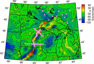
The MRS hosts the largest gravity anomaly in the interior of the North American continent: The 1300 km-long rift may contain more than a million km3 of mafic rocks (Cannon, 1992), which produce a Bouguer gravity anomaly up to 65 mgal (Chase and Gilmer, 1973) which is shown in Figure 1. Negative gravity anomalies flank the rift, caused by stacks of less dense sedimentary rocks that accumulated in the rift basin. As the crust extended due to rifting, normal faults formed to take up the thinning of the lithosphere. Once rifting stopped, the faults were reactivated as thrust faults to accommodate compression, which pushed the density anomalies closer to the surface thereby enhancing their effects on the gravity and magnetic fields (Cannon, 1994; Anderson, 1997). The rift was the last major event in the evolution of mid-continental geology, and the region has been tectonically quiet for about a billion years. One of the goals of SPREE is to resolve the mantle structure of the region to determine the role of the mantle in rifting event.
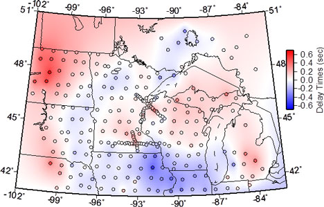
One of numerous ways in which we use SPREE data to analyze mantle structure is through teleseismic tomography. To date, more than 25 thousand teleseismic P-wave delay times from over 130 earthquakes have been measured from SPREE seismograms using the AIMBAT package (Lou et al., 2012). Figure 2 shows the average P-wave delay time for each SPREE and TA station in our study area. The average teleseismic delays (Figure 2) range from -0.6 to +0.6 s. These delay times contain contributions from mantle anomalies and crustal anomalies. However, the delay times are not obviously correlated with the MRS volcanism in the crust, suggesting that there could be significant mantle heterogeneity obscuring the effects of the shortened rift’s volcanic intrusions and sediments. Vice versa, in order to more accurately image mantle structure and evaluate its significance to the MRS, we need to know more about the crust. To this end, ongoing SPREE data analyses aim to image crustal structure through, for example, receiver function analysis, H/V ratios, and ambient noise tomography. We also rely on a handful of active source profiles that were shot across the rift (Behrendt et al. 1990; Chandler et al. 1989)
SPREE has also recorded a number of rare, relatively large earthquakes in the stable interior of North America, including M > 5 events in Colorado, Virginia, and Oklahoma. These fortuitously-timed earthquakes have greatly enhanced raypath coverage for studies of regional S and surface waveforms. Shortly after deployment, SPREE recorded an M 2.5 earthquake in western Minnesota. This was was the first earthquake recorded in Minnesota since 1994. In addition to these rare events, SPREE routinely records earthquakes from the active margin of North America.
SPREE has operated at a 97 percent data return average during the first half of the experiment’s duration. At the time of this writing we are mid-way through our spring 2013 servicing run (Figure 3). With more SPREE data to analyze, we will be able to address the experiment’s original research questions through completion of planned and ongoing data analyses. These includes noise characterization, ambient noise tomography, H/V ratios, shallow and deep receiver functions, SKS splitting, gravity modeling, and S and surface wave train modeling, among others. At the recent 2013 EarthScope National Meeting graduate students, staff, and PIs from the collaborating and other institutions had a first opportunity to compare our preliminary analyses of SPREE data and discuss potential implications of our findings.
Good relationships with and outreach to station hosts and the wider community has been an integral part of SPREE. We send letters to our landowners roughly twice a year to keep them updated on the status of SPREE and share new scientific results and/or seismograms of a major or otherwise relevant earthquake. SPREE provided us the opportunity to meet very helpful landowners in very friendly communities, which we would not have experienced otherwise. Co-PIs and students have given several interviews to local radio, newspapers, and “the web” (e.g. Earthscope Channel on YouTube).
We have also embraced social media in our outreach efforts: We maintain a Facebook page (www.facebook.com/superiorrifting), a Twitter account (@seismoSPREEDOM) and our project website (www.earth.northwestern.edu/spree). We use these as tools to keep landowners informed, to share information and documentation amongst the multi-institutional members of the SPREE Team*, and inform anyone else that might be interested. Updates can take the form of pictures from the field, locations and times of project presentations at conferences, or links to new findings posted on our website. During installation and service runs, social media have also allowed teams to stay updated on each other’s status. (This occasionally sparks friendly rivalries, such as a competition to see who can pack the most instruments and tools in one van.)
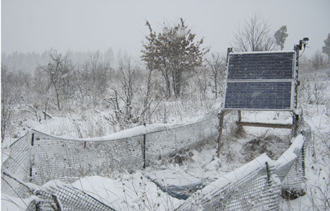
As an FA experiment, SPREE stations do not have a communications link and thus we leave the comfort of our offices to brave the elements in the field during data collection and station servicing. We have faced heat, storms, swamps, ticks, black flies, and other insects, thieves, hunters, as well as most recently a blizzard that required cross-country skis to access our stations.
The MRS is evidence of the Earth’s Mesoproterozoic attempt completely redefine the structure of the evolving Laurentia, the Precambrian, cratonic core of North America. The rift was obviously not successful and Laurentia survived within North America for the past billion years, though now blanketed with Phanerozoic sediments and Quaternary glacial till. SPREE is on its way to imaging the crust and mantle beneath this blanket and expand the story of the evolution of the deep midcontinent, which began with the documentation of basaltic rocks on the shores of Lake Superior over one hundred years ago, measurements of gravity anomalies about fifty years ago, and active source seismic profiles shot about twenty five years ago (Craddock et al, 2013).
Acknowledgments
We are most grateful to all private landowners, State, County and Provincial Park Rangers for hosting our SPREE stations. We thank the IRIS PASSCAL program and particularly Katyliz Anderson, Noel Barstow, Mike Fort, Jackie Gonzalez, and Eliana Dotson, for enabling SPREE with instruments, care, and expertise. SPREE is funded by NSF under grant EAR-0952345.
Citations
Anderson, R. “Keweenawan Supergroup clastic rocks in the Midcontinent Rift of Iowa”, GSA Spec. Paper, 312, p. 211-230, 1997. Behrendt, J. C., et al. "GLIMPCE seismic reflection evidence of deep-crustal and upper-mantle intrusions and magmatic underplating associated with the Midcontinent Rift system of North America." Tectonophysics 173.1, p. 595-615, 1990. Cannon, W. F. “The North American Midcontinent Rift beneath the Lake Superior region with emphasis on its geodynamic evolution”. Tectonophysics, 213, p. 41–48, 1992. Cannon, W.F. “Closing of the Midcontinent rift-A far-field effect of Grenvillian compression”, Geology, 22.2, p. 155-158, 1994. Chandler, Val W., et al. "Interpretation of seismic reflection, gravity, and magnetic data across middle Proterozoic mid-continent rift system, northwestern Wisconsin, eastern Minnesota, and central Iowa." AAPG Bulletin73.3, p. 261-275, 1989. Chase, Clement G., and Todd H. Gilmer. "Precambrian plate tectonics: The midcontinent gravity high." Earth and Planetary Science Letters, 21.1, p. 70-78, 1973. Craddock, J.P., Alex Konstantinou, Jeffrey D. Vervoort, Karl R. Wirth, Cam Davidson, Lee Finley-Blasi, Natalie A. Juda, and Erin Walker, “Detrital Zircon Provenance of the Mesoproterozoic Midcontinent Rift, Lake Superior Region, U.S.A.”, Journal of Geology, 2013. Lou, Xiaoting, Suzan van der Lee, and Simon Lloyd. "AIMBAT: A Python/Matplotlib Tool for Measuring Teleseismic Arrival Times." Seismological Research Letters, 84.1, p. 85-93, 2013.


