
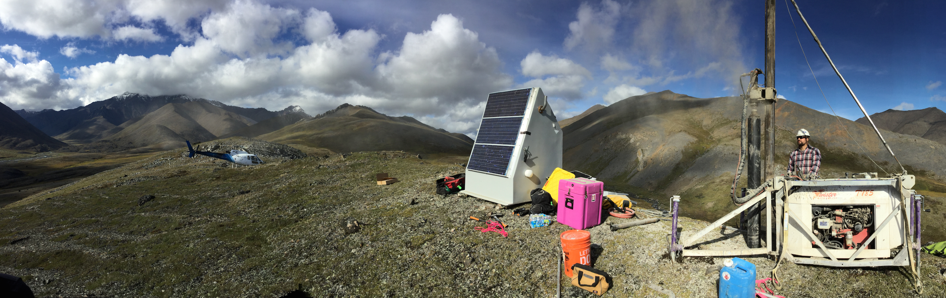
Elliot Wilson of Pioneer Earthworks operates the drill at Alaska Transportable Array station D27M. Photo by Max Enders, IRIS.
- by Kasey Aderhold, IRIS
After covering the contiguous United States from coast to coast with a grid of nearly 1700 temporary sites, the final seismic station of the NSF-funded EarthScope Transportable Array (TA) has been installed in Alaska. Station A19K lies on the edge of an abandoned airstrip far above the Arctic Circle. The nearest sizeable population center from this station is 127 miles to the northeast, at Utqiaġvik (formerly known as Barrow), the most northerly city in the U.S. This station completes the installation of the currently operating 280-station network that continuously records ground motion from local, regional and global earthquakes and broadcasts its data in real-time.
Alaska has always been the final goal of the TA, ever since IRIS began installing stations across the Lower 48 in 2004. Using helicopters, field teams were able to deploy stations across the most remote regions of Alaska. A custom, lightweight drill was designed to make and case 10-feet boreholes in rock, permafrost, and other ground types. A newly available posthole seismometer was placed directly into each hole and then connected to a sturdy hut containing all the electronics, batteries, and solar panels needed to keep the station powered and operating and transmitting the recorded data autonomously.
Signals collected from the sensors are sent to the Array Network Facility in San Diego in real time as soon as a station is built, and all data are made freely available to the public through the IRIS Data Management Center. The Alaska stations have also hosted additional scientific sensors. Meteorological sensors are mounted to the hut at 130 of the most remote stations. Wind, temperature, humidity, and precipitation data are streamed from the stations and incorporated into NOAA’s weather forecasting. Soil temperature probes have also been installed at about 80 of the northern sites as part of a NASA ABoVE permafrost study. Strong-motion sensors are strategically placed at stations near the Aleutian subduction zone to capture the more powerful seismic signals, and the auxiliary Alaska Amphibious Community Seismic Experiment will be deployed in 2018.
The success of this ambitious scientific endeavor of the Alaska TA is largely due to the focused efforts of a small number of employees who have coordinated complicated shipping schedules and diverse land-use permits, and spent the past three summers navigating poor weather conditions, fires, and wildlife across Alaska and western Canada. At times, conditions were harsh. Many stations have been gnawed by curious bears, some have faced winds over 120 mph, and one station was reduced to cinders in the 2015 Sockeye fire (it was rebuilt the same year). This project has benefitted from significant collaboration with the Alaska Earthquake Center, whose staff is intimately acquainted with the challenges of working in Alaska. Overall, the stations are durable and performing well.
With so much invested to deploy these stations, operators and researchers are investigating ways to extend the lives of these stations past their planned removal dates beginning in 2019. EarthScope left a lasting footprint in the Lower 48 by transferring 158 TA stations to the Central and Eastern United States Network (CEUSN). There is hope that a similar footprint will remain in Alaska.
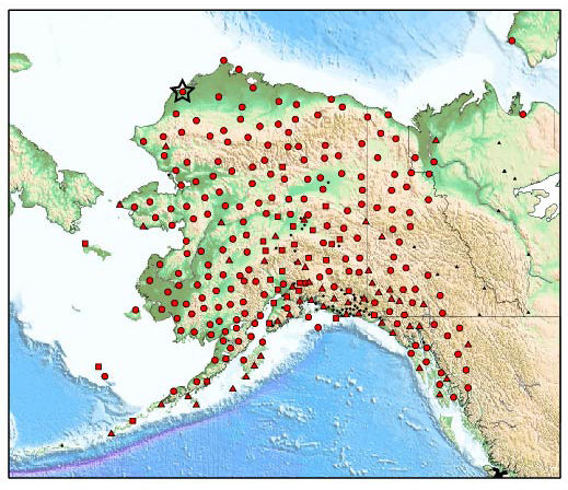
Map of the EarthScope Alaska Transportable Array stations (red symbols). Circles are new seismic stations, squares are stations upgraded with a posthole sensor, and triangles are existing stations operated by collaborating networks (Alaska Earthquake Center, Alaska Volcano Observatory, Alaska Tsunami Warning Center). Station A19K, the final station of the Alaskan Transportable Array, is marked with a star.
EarthScope, funded by the National Science Foundation, is exploring the structure and evolution of the North American continent and the processes controlling earthquakes and volcanic eruptions. The Transportable Array is constructed, operated, and maintained by the Incorporated Research Institutions for Seismology (IRIS) through cooperative agreements with NSF. Staff at the IRIS Alaska Operations Center has been supported by the Array Operations Facility at New Mexico Tech, the Array Network Facility at University of California San Diego, the IRIS Data Management Center, and IRIS Headquarters. Collaboration and support from the Alaska Earthquake Center has been key to the success of the Alaska component of the Transportable Array, along with cooperation with the Alaska Volcano Observatory, Alaska Tsunami Warning Center, UNAVCO, Canadian Hazards Information Service, Yukon Geological Survey, Yukon Wildlands, and Natural Resources Canada. Data is archived at the IRIS DMC under the _US-TA network code. More information is available at http://usarray.org/Alaska.


