
Articles
2019
Exploring a Changing Continent Using a Plate Boundary Observatory
2019-02-14
Geodesy is the science of measuring the size, shape, and gravity field of Earth, and how these change with time.
Fifteen Years of Earth Science Exploration
2019-02-14
The EarthScope National Office
Education Corner: Final inSights Issue
2019-02-14
Sharing Science through the EarthScope Speaker Series and Save the Date for the EarthScope Legacy Education and Outreach Virtual Workshop2018

New EarthScope Video!
2018-12-12
15 Years of Geoscience Discovery and Education in North America
EarthScope Top 10 Discoveries
2018-12-07
,
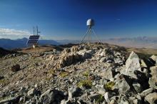
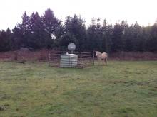
PBO Station Highlight: A Puzzle in the Midcontinent
2018-08-31
What causes earthquakes in the interior of North America, far from plate boundaries?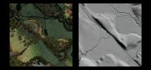
EarthScope’s Laser Vision: Sharing Lidar Data
2018-05-07
High-resolution images reveal fault movement—before and after quakes—to experts and students
EarthScope Announcements
2018-05-04
inSights Spring 2018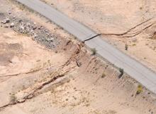
PBO Station Highlight: P496 Is Only One Piece of the Story
2018-05-04
PBO station P496 not only shook during the 7.2 El Mayor–Cucapah earthquake in northwestern Mexico, but moved permanently as a result of it.
Education Corner
2018-01-24
Science Fair season is coming soon, giving students a chance to explore hands-on science. (Photo by Molly Tedesche)
In every inSights issue, we feature a few of the dozens of
2017
Creeps and starts on the San Andreas fault near San Juan Bautista
2017-11-10
Want to dig deeper? Click on the "advanced" button in the article for scientific details.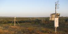
P472: Engineering for Earthquakes
2017-10-16
PBO Station Highlight October 2017
Education Corner
2017-10-12
In every InSights issue, ESNO features two of the dozens of tools, modules, and activities that utilize EarthScope data to benefit a wide variety of users (K–12, university educators, informal programs like museums or after-school programs).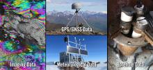
Data Tools
2017-08-24
Introducing a new how-to video series for accessing UNAVCO's geodetic data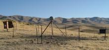
P085: Tiny Motions Matter
2017-07-25
PBO Station Highlight Summer 2017
EarthScope's Final National Meeting
2017-06-16
A culmination of 15 years of expansive geoscience research
AB50: Quick Responder
2017-05-08
PBO Station Highlight May 2017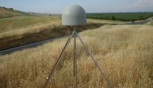
Salt Canyon, California
2017-02-01
PBO Station P208 watches the grass grow...literally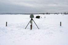
Improving Snow-Depth Forecasting with EarthScope’s Plate Boundary Observatory
2017-02-01
by Gail McCormick - Winter 2017

Winter 2017 Education Corner
2017-02-01
In every InSights issue, ESNO features two of the dozens of tools, modules, and activities that utilize EarthScope data to benefit a wide variety of users (K–12, university educators, informal programs like museums or after-school programs)2016
Fall Creek, Oregon
2016-10-24
Borehole strainmeter B030 records slip around the world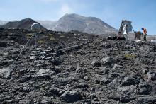
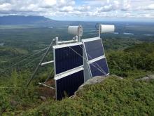
Watching a Volcano Breathe
2016-10-24
Plate Boundary Observatory monitoring networks on Mount St. Helens
Fall 2016 Education Corner
2016-10-23
For every InSights issue, we feature two of the dozens of tools, modules, and activities that utilize EarthScope data to benefit a wide variety of users. We intend to reach K–12 and university educators, as well as informal programs like museums.
Triangulation Point, Oregon
2016-10-10
PBO Station P405 battles the elements at an energetic plate boundary
Creeping Calamity
2016-09-20
Using the Plate Boundary Observatory to monitor landslide motion. GPS Station AC55 in Alaska was moving more than expected. Some movement was normal due to tectonic plate movement and residual motion from previous earthquakes—other GPS stations...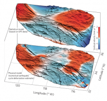
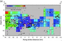
The Vertical Fingerprint of Earthquake Cycle Loading in Southern California
2016-09-19
Science Nugget - By Bridget Smith-Konter (University of Hawaii at Manoa), David Sandwell (Scripps Institution of Oceanography), Xiaopeng Tong (University of Washington…
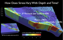
Locked, Loaded and Looming?
2016-09-19
Exploring earthquake cycle stress history of seismically active faults of the San Andreas Fault System
Augustine Island, Alaska
2016-08-10
PBO Station AV03 Takes a Blow
2016 UNAVCO Science Workshop
2016-04-15
New Uses for the Plate Boundary Observatory2015
Drawing Lines from the Air
2015-12-22
High-resolution Topographic Data Comes of Age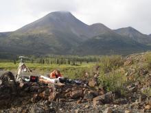
Mackenzie Mountains Mystery: New EarthScope Project Peers Underneath an Unlikely Mountain Range
2015-12-22
By Kerry Klein - Winter 2016
At first blush, the Mackenzie Mountains in northern Canada could be the Rocky Mountains’ long lost sibling. They appear just as angular and…
Back to Mothership
2015-12-01
How PBO data get from Everywhere to somewhere
Low-Cost Additions to the Plate Boundary Observatory for Earthquake Early Warning
2015-04-15
By Doerte Mann and Beth Bartel - Spring 2015
One of the major benefits of the Plate Boundary Observatory (PBO) is its contribution to prototype Earthquake Early Warning systems (EEW).

EarthScope Science and Disaster Preparedness
2015-01-14
Engaging Educators in EarthScope Science and Disaster Preparedness Through Professional Development Workshops in Coastal Cascadia2014
Teaching Educators: PBO Data and Classroom Resources
2014-10-14
by UNAVCO - Fall 2014

Workshop Report: Modern and Ancient Basement Arches and the Connection to Flat Slab Subduction
2014-09-22
By Megan Anderson (CC), Kate Miller (TAMU), Susan Beck (UA), and Margarete Jadamec (UH) - Fall 2014
The structural dissimilarity between basement-involved arches and thin…
Stability of PBO GPS Monument Types
2014-03-22
Project Highlight
PBO Weighs California’s Water Resources
2014-02-20
By Donald Argus, Yuning Fu, and Felix Landerer - Summer 2014
Approximately 500 sites in California, most of which are part of the Plate Boundary Observatory, are weighing…
Helicopter Fieldwork in the PBO Alaska Region
2014-02-02
By Ellie Boyce - Summer 2014
With high-elevation GPS stations melting out of the snow and the weather becoming milder, the PBO Alaska region began annual helicopter-based…
2013
Hitting Hot Water with PBO Borehole Strainmeters in the Yellowstone Caldera
2013-12-22
By Glen Mattioli and David Mencin - Winter 2014
Data from the Yellowstone Gladwin Tensor strainmeter (GTSM) network are improving the understanding of the structure of…
Monitoring Surface Deformation at Long Valley Caldera, California
2013-09-22
By Kang Hyeun Ji - Fall 2013
Continuous monitoring of volcanic activity provides a way to detect changes from usual activity, provide warning impending eruptions, and…
PBO Multiple Monument Comparison Project
2013-06-22
By UNAVCO - Summer 2013
PBO Change Order 35 authorized UNAVCO to construct two additional geodetic monuments at five existing PBO stations in order to test and compare…
Deformation of the Wasatch Fault System
2013-03-22
Plate Boundary Observatory Data2012
PBO GPS Updates
2012-09-22
By Glen Mattioli, UNAVCO - Fall 2012
Currently, there are 1120 GPS sites and 28 tilt meters, as well as numerous other strainmeters actively measuring deformation. In…
Tales from the Field: PBO Installation in Alaska
2012-03-22
Max Enders - Spring 2012
When UNAVCO set about building the Earthscope Plate Boundary Observatory (PBO) no challenge was nearly as daunting as the prospect of installing…
Spring 2012 Facilities Status
2012-03-22
Spring 2012
USArray Status
The Transportable Array (TA) continues to roll eastward across the US. Having crossed the Mississippi River in March 2011, the TA will…
2010
Using GPS to Measure Soil Moisture, Snow Depth and Vegetation Growth
2010-09-22
GPS data collected as part of PBO, though, contain additional information that is very useful in ways unforeseen when the original PBO science plan was created.

