
By integrating scientific information from its multi-disciplinary observatories, which use a wide variety of geophysical instrumentation, EarthScope's scientists are developing a comprehensive, time-dependent picture of the continent beyond that which any single discipline can achieve. Data obtained from these observatories allows scientist to describe how geological forces shaped North America's landscape and contribute to the public's understanding of our dynamic Earth. EarthScope's use of advanced instrumentation permits us to answer some of the outstanding questions in Earth Sciences by looking deeper, increasing resolution, and integrating diverse measurements and observations. Support for science projects is primarily awarded via a rigorous process of peer review of proposals submitted to the National Science Foundation.
Freely available, high precision data can be viewed as the most important legacy of the National Science Foundation's largest investment in solid-Earth Science.
The USArray component of EarthScope is a continental-scale seismic and magnetotelluric observatory designed to provide a foundation for integrated studies of continental lithosphere and deep Earth structure over a wide range of scales. USArray is providing new insight and new data to address fundamental questions surrounding earthquake physics, volcanic processes, core-mantle interactions, active deformation and tectonics, continental structure and evolution, geodynamics, and crustal fluids (magmatic, hydrothermal, and meteoric).
The USArray component of EarthScope is a continental-scale seismic observatory designed to provide a foundation for integrated studies of continental lithosphere and deep Earth structure. Over the wide frequency range of seismic waves transmitted through the Earth, the sensors of the permanent and transportable seismic and magnetotelluric arrays will resolve the smallest background motions at the quietest of sites, while remaining “on scale” for all but the largest ground motions from regional earthquakes. USArray consists of a portable array (the Transportable Array) of 400 seismometers that have been deployed across the United States over a 10-year period. In addition, a "flexible component" array will be available to be deployed in areas where a denser network of seismometers is required. The Magnetotelluric Transportable (MT) Array assists shorter-period investigations at hundreds of sites in the continental US. Data from these sites are collected on a regular basis through recovery of data storage modules. The USArray project is guided by the USArray Advisory Committee. For more information about the USArray observatory, visit the USArray website.
Data
All USArray data components are available through the IRIS Data Management Center (DMC) including:
Station Lists and Maps (Transportable Array / Flexible Array / Reference Network / Magnetotellurics stations),
Active Stations with links to station details,
Virtual Network Query (via SeismiQuery),
MUSTANG (Modular Utility for STAtistical kNowledge Gathering),
LASSO (Latest Assessment of Seismic Station Observations), and Overview of Data Request Tools
All USArray seismic data receive quality control at the IRIS Data Management Center (DMC), the Array Network Facility (ANF), the Array Operations Facility (AOF), or a Data Collection Center of the USGS in Albuquerque, NM or Golden, CO. Additionally, the IRIS DMC runs a suite of algorithms against all data arriving at the DMC in real time. In some cases, these algorithms are good indicators of data quality. All USArray MT data receive quality control through Oregon State University's (OSU) USArray Data QC group, where robust remote reference methods are used to generate MT transfer functions and induction vectors.
The IRIS DMC is the access point for you to gain access to waveforms, metadata, MT time series and derived data products from USArray stations.
USArray Seismic Data Products
Seismic data holdings pertaining to all components of USArray, SAFOD, and PBO can be found at the IRIS Data Management Center (DMC).
These are some of the data products, please let us know if you have any you would like us to add here.
IRIS DMC Event Plot
The IRIS DMC's Event Plot product is a suite of plots that are automatically generated following magnitude 6+ earthquakes. The plots include station maps, global body wave record sections, phase aligned record sections, USArray body and surface wave record sections, virtual array P-waves and vespagrams, body wave envelopes and P-wave coda stacks. The plots use broadband data available at the IRIS DMC at the time the product was generated. Direct access to event plot. For more IRIS DMC data products visit http://www.iris.edu/dms/products/eventplots/.
Earth Model Collaboration
EMC serves as a repository of Earth models with the aim of providing the research community with access to various Earth models, visualization tools for model preview, facilities to extract model data/metadata and access to the contributed processing software and scripts. http://ds.iris.edu/ds/products/emc/
Shear Wave Splitting Database
A comprehensive shear-wave splitting database for North America (NA-SWS-1.1) is available from Kelly Liu (Missouri S&T) at www.mst.edu/~liukh/SWS. The database currently contains over 6000 splitting parameters for more than 850 stations in North America, all obtained in a homogeneous fashion. The database will be updated as the USArray moves east, improving spatial coverage and resolution continent wide.
Receiver Reference Models
The EarthScope Automated Receiver Survey (EARS) is now implemented at the IRIS DMC. EARS provides average crustal Vp/Vs ratios beneath USArray TA stations. For more information visit www.iris.edu/dms/products/ears. References: Crotwell, H.P. and T.J. Owens, Automated estimation of bulk crustal properties, IRIS Newsletter, 3:4-5, 2006 and Crotwell, H.P. and T.J. Owens, Automated receiver function processing, Seis. Res. Lett., 76:6, 2005.
Ambient Seismic Noise
The Center for Imaging the Earth's Interior at the University of Colorado provides images of seismic velocity derived from ambient seismic noise. The site contains Rayleigh and Love wave group and phase velocity maps since inception of the TA array in October 2004 illustrating improved resolution and increased spatial coverage. Maps are for several period bands from 8 s to 40 s sensitive to crust and uppermost mantle structure. http://ciei.colorado.edu/ambient_noise/
Earthquake Ground Motion Animations
The automated USArray Ground Motion Visualization (GMV) product of the IRIS DMC's is available at www.iris.edu/spud/gmv. Basic explanations about the animations are provided at IRIS Education and Outreach and include a tutorial describing different aspects of the animations. The animations of seismic waves as they sweep across the USArray illustrate regional and teleseismic wave propagation phenomena and were first introduced by Charles Ammon (Penn State) (http://eqseis.geosc.psu.edu/~cammon/QA/).
Regional Moment Tensors
Robert Herrmann's regional moment tensor solutions for moderate-to-large earthquakes in the U.S. from USArray TA and ANSS broadband seismic stations. Results are obtained in the time and the frequency domain. For both approaches and each event waveform fit and amplitude-phase match figures are provided that allow users to evaluate moment tensor quality. http://www.eas.slu.edu/eqc/eqc_mt/MECH.NA/
Searchable Product Depository
The Searchable Product Depository (SPUD) is the IRIS DMC's data product management system. SPUD products are typically derived from raw waveform data and are complementary to the IRIS DMC waveform data. Products can be images, movies, text files or other processing results such as moment tensors, MT transfer functions, calibration data, etc. (www.iris.edu/spud).
Real time TA Data
Latest 2 hr Transportable Array BHZ data
Latest 24 hr Transportable Array BHZ data
Latest 24 hr Transportable Array LHZ data
Transportable Array State-of-Health (updated every 2.5 minutes)
Infrasound - TAIRED
The TA Infrasound Reference Event Database (TAIRED) is a user-supported evolving database that serves as a reference event depository where researchers can contribute new events, provide a new solution for an existing event and find sample infrasound events for their use. This database was initially populated from observations on the USArray infrasound data, event bulletins, news on meteorological phenomena, explosions and rocket launches. http://ds.iris.edu/ds/products/infrasound-taired/
A primary objective of the PBO is to quantify three-dimensional ground deformation and its temporal variability across the active boundary zone between the Pacific and North American plates. Centimeter to millimeter-level measurements of surface and near surface motion through Global Positioning System (GPS) stations, borehole geophysics, laser strainmeters, accelerometers, and geodetic imaging has far reaching implications regarding earthquakes, volcanic unrest, subsidence, landslides, extraction or injection of fluids, loading or unloading of water, ice or snow, and other Earth processes.
Sounding of the atmosphere through GPS (i.e., satellite to receiver pathways) to measure total electron content in the ionosphere and precipitable water vapor in the troposphere impacts research regarding space weather, severe weather, and atmospheric dynamics. Probing of surface conditions through GPS reflectrometry (i.e., satellite to surface to receiver pathways) to measure soil moisture, snow depth, vegetation moisture index, and other features, provides crucial information regarding the water cycle and water resources. Advances in satellite systems through the Global Navigation Satellite System (GNSS) and innovations in GPS and GNSS receivers, other instrumentation, data processing, computing power, and cyberinfrastructure have allowed the scientific community to better address an array of critical scientific and societal problems using space and terrestrial geodetic techniques—in geographically distributed areas.
Complete information is available on the UNAVCO/PBO website.
You can access how-to video series for accessing UNAVCO's geodetic data
Geodetic Data
The Plate Boundary Observatory collects, archives and distributes data from a broad networks of over 1100 GPS and seismic sites located across the continental United States and Alaska. These data are freely and openly available to the public, with equal access provided for all users. PBO data includes the raw data collected from each instrument; quality-checked data in formats commonly used by PBO's various user communities, and processed data such as calibrated time series, velocity fields, and error estimates.
One data access method for PBO GPS data is using the UNAVCO Data Archive Interface:
- Normal-rate (15-second sampled) data: PBO GPS Core Network
- High-rate (1-second and 0.2-second sampled) data: PBO High Rate
Requests for real-time GPS/GNSS data from the PBO network needs to be made by requesting an account by emailing rtgps@unavco.org.
The PBO web page provides access to geodetic data from multiple instrument networks. The 1100-station GPS network is the largest component, and raw and processed data are available from PBO/GPS data product page and the UNAVCO Data Archive Interface. A subset of the GPS stations are streamed in realtime. Subnetworks of borehole strainmeters, borehole seismometers, tiltmeters, pore pressure sensors, and laser strainmeters are distributed in tectonic and volcanic regions of interest. Borehole data are accessible from PBO, Northern Califiornia Earthquake Data Center, and IRIS. PBO has collections of remote sensing data acquired as part of the GeoEarthScope project. Airborne LiDAR data can be obtained from the Open Topography Portal, and InSAR data can be obtained from the UNAVCO SAR Archive.
PBO Geodetic Data Products
The PBO web page provides access to geodetic data from multiple instrument networks.
Terrestrial Water Cycle Products
The PBO H2O project at the University of Colorado provides daily estimates of volumetric soil moisture, snow depth/snow water equivalent, and vegetation water content using reflected GPS signals. Ancillary data (temperature, precipitation, NDVI, GPP, photos, google maps) are also provided.
For PBO H2O data products visit the PBO H2O data portal.
Cascadia Interactive Tremor Catalog
Aaron Wech’s Cascadia tectonic tremor catalog is available at www.pnsn.org/tremor. This interactive website is updated daily and catalogs tremor epicenters from northern California to mid-Vancouver Island using regional networks and PBO data. Wech, A.G. (2010), Interactive Tremor Monitoring, Seis. Res. Lett., 81:4, 664-669, 2010.
Geodetic monitoring of the western US and Hawaii
Tim Melbourne and colleagues in the Department of Geological Sciences at Central Washington University maintain a web site that is updated daily to show results from ~1500 continuous GPS stations along the Pacific/North American plate boundary, ranging from Alaska to the U.S./Mexico border. http://www.geodesy.org/
For daily updates of GPS data from Hawaii, see www.soest.hawaii.edu/pgf/SEQ
Time-dependent Strain
The Stony Brook EarthScope Project, managed by William Holt, provides models of time-dependant strain associated with a number of recent earthquakes and other geologic events as constrained by GPS data. Software, tutorials and reference models are also available to construct models spanning time scales of days to decades and spatial scales of kilometers to megameters. http://gsrm.unavco.org/
EarthScope Geodetic Imagery
EarthScope Geodetic Imagery: The "OpenTopography Portal" (www.opentopography.org) provides access to high-resolution topographic data, including LiDAR data acquired by GeoEarthScope. Data can be downloaded as DEMs, point clouds, and KML files. Data processing and visualization tools and a user discussion forum are also available. Image here shows high-resolution GeoEarthScope LiDAR data from northern California overlain on 10 m resolution topography from the USGS.
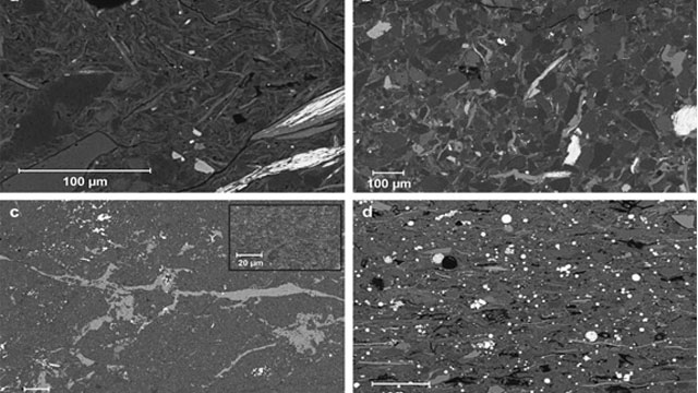
The San Andreas Fault Observatory at Depth (SAFOD) was a 3-kilometer deep hole drilled directly into the San Andreas Fault midway between San Francisco and Los Angeles, near Parkfield, CA. Located in an area that has ruptured six times since 1857, the hole provided the first opportunity to observe directly the conditions under which earthquakes occur, to collect rocks and fluids from the fault zone for laboratory study, and to continuously monitor the physical condition within an active earthquake nucleation zone.
SAFOD Data
Data holdings from the SAFOD Project can be accessed on the International Continental Scientific Drilling Program (ICDP) and the Northern California Earthquake Data Center (NCEDC) website. The data consist mainly of cutting and mud sample reports, seismic data from borehole seismometers, core boxes, core logging, and lithological reports updated daily. Images of the core are available here.
SAFOD physical samples are curated at the Gulf Coast Repository (GCR) at Texas A&M University, under the supervision of John Firth.
If you have core sampling questions or requests, please contact:
Judith Chester (chester@tamu.edu)
John Firth (firth@iodp.tamu.edu)
SAFOD Data Products
Data holdings from the SAFOD Project can be accessed on the Intercontinental Drilling Program (ICDP) and the Northern California Earthquake Data Center (NCEDC) website.
EarthScope Observatories provide access to raw and processed data, recorded on various networks and instruments. EarthScope researchers provide higher level products based on data from the observatories, or funded by grants from EarthScope. We urge EarthScope scientists who have data products they would like to share to contact the EarthScope National Office.
USArray Seismic Data Products
Seismic data holdings pertaining to all components of USArray, SAFOD, and PBO can be found at the IRIS Data Management Center (DMC).
IRIS DMC Event Plot
The IRIS DMC's Event Plot product is a suite of plots that are automatically generated following magnitude 6+ earthquakes. The plots include station maps, global body wave record sections, phase aligned record sections, USArray body and surface wave record sections, virtual array P-waves and vespagrams, body wave envelopes and P-wave coda stacks. The plots use broadband data available at the IRIS DMC at the time the product was generated. Direct access to event plot. For more IRIS DMC data products visit http://www.iris.edu/dms/products/eventplots/.
Shear Wave Splitting Database
A comprehensive shear-wave splitting database for North America (NA-SWS-1.1) is available from Kelly Liu (Missouri S&T) at www.mst.edu/~liukh/SWS. The database currently contains over 6000 splitting parameters for more than 850 stations in North America, all obtained in a homogeneous fashion. The database will be updated as the USArray moves east, improving spatial coverage and resolution continent wide.
P-Wave Tomography
Scott Burdick et al.'s P-wave tomography using data from regional and teleseismic distances. The dataset includes USArray TA data and, as the array moves east, the model will be updated leading to a high-resolution image of upper mantle structure beneath the U.S. Reference: Burdick, S., et. al., Seismological Research Letters, 79(3), 384-392, May/June 2008. http://web.mit.edu/~sburdick/www/tomography.html
Receiver Reference Models
The EarthScope Automated Receiver Survey (EARS) is now implemented at the IRIS DMC. EARS provides average crustal Vp/Vs ratios beneath USArray TA stations. For more information visit www.iris.edu/dms/products/ears. References: Crotwell, H.P. and T.J. Owens, Automated estimation of bulk crustal properties, IRIS Newsletter, 3:4-5, 2006 and Crotwell, H.P. and T.J. Owens, Automated receiver function processing, Seis. Res. Lett., 76:6, 2005.
Ambient Seismic Noise
The Center for Imaging the Earth's Interior at the University of Colorado provides images of seismic velocity derived from ambient seismic noise. The site contains Rayleigh and Love wave group and phase velocity maps since inception of the TA array in October 2004 illustrating improved resolution and increased spatial coverage. Maps are for several period bands from 8 s to 40 s sensitive to crust and uppermost mantle structure. http://ciei.colorado.edu/ambient_noise/
Earthquake Ground Motion Animations
The automated USArray Ground Motion Visualization (GMV) product of the IRIS DMC's is available at www.iris.edu/spud/gmv. Basic explanations about the animations are provided at IRIS Education and Outreach and include a tutorial describing different aspects of the animations. The animations of seismic waves as they sweep across the USArray illustrate regional and teleseismic wave propagation phenomena and were first introduced by Charles Ammon (Penn State) (http://eqseis.geosc.psu.edu/~cammon/QA/).
Regional Moment Tensors
Robert Herrmann's regional moment tensor solutions for moderate-to-large earthquakes in the U.S. from USArray TA and ANSS broadband seismic stations. Results are obtained in the time and the frequency domain. For both approaches and each event waveform fit and amplitude-phase match figures are provided that allow users to evaluate moment tensor quality. http://www.eas.slu.edu/eqc/eqc_mt/MECH.NA/
Searchable Product Depository
The Searchable Product Depository (SPUD) is the IRIS DMC's data product management system. SPUD products are typically derived from raw waveform data and are complementary to the IRIS DMC waveform data. Products can be images, movies, text files or other processing results such as moment tensors, MT transfer functions, calibration data, etc. (www.iris.edu/spud).
S-wave Tomography
3-D S-velocity model available from Dr. Suzan van der Lee from Northwestern Univesity providing data set for upper mantle S velocity structure of North America. http://lunar.earth.northwestern.edu/research/suzan/research.html
PBO Geodetic Data Products
The PBO web page provides access to geodetic data from multiple instrument networks.
Terrestrial Water Cycle Products
The PBO H2O project at the University of Colorado provides daily estimates of volumetric soil moisture, snow depth/snow water equivalent, and vegetation water content using reflected GPS signals. Ancillary data (temperature, precipitation, NDVI, GPP, photos, google maps) are also provided.
For PBO H2O data products visit the PBO H2O data portal.
Cascadia Interactive Tremor Catalog
Aaron Wech’s Cascadia tectonic tremor catalog is available at www.pnsn.org/tremor. This interactive website is updated daily and catalogs tremor epicenters from northern California to mid-Vancouver Island using regional networks and PBO data. Wech, A.G. (2010), Interactive Tremor Monitoring, Seis. Res. Lett., 81:4, 664-669, 2010.
Geodetic monitoring of the western US and Hawaii
Tim Melbourne and colleagues in the Department of Geological Sciences at Central Washington University maintain a web site that is updated daily to show results from ~1500 continuous GPS stations along the Pacific/North American plate boundary, ranging from Alaska to the U.S./Mexico border. http://www.geodesy.org/
For daily updates of GPS data from Hawaii, see www.soest.hawaii.edu/pgf/SEQ
Time-dependent Strain
The Stony Brook EarthScope Project, managed by William Holt, provides models of time-dependant strain associated with a number of recent earthquakes and other geologic events as constrained by GPS data. Software, tutorials and reference models are also available to construct models spanning time scales of days to decades and spatial scales of kilometers to megameters. http://www.eserc.stonybrook.edu/strain/
EarthScope Geodetic Imagery
EarthScope Geodetic Imagery: The "OpenTopography Portal" (www.opentopography.org) provides access to high-resolution topographic data, including LiDAR data acquired by GeoEarthScope. Data can be downloaded as DEMs, point clouds, and KML files. Data processing and visualization tools and a user discussion forum are also available. Image here shows high-resolution GeoEarthScope LiDAR data from northern California overlain on 10 m resolution topography from the USGS.
SAFOD Data Prodcuts
Data holdings from the SAFOD Project can be accessed on the Intercontinental Drilling Program (ICDP) and the Northern California Earthquake Data Center (NCEDC) website


