
By Gail McCormick - Summer 2016
GPS Station AC55 in Alaska was moving more than expected. Some movement was normal due to tectonic plate movement and residual motion from previous earthquakes—other GPS stations in the area moved around 0 to 3 mm per year, after all. But AC55 moved over 5.5 cm per year.
“We saw that something was wrong and then realized—no, that’s a landslide,” says Dr. Guoquan Wang, Associate Professor of Geophysics, Geodesy, and Geosensing Systems Engineering at the University of Houston.
Landslides can damage infrastructure and prove fatal, leading to yearly losses of up to $4 billion and as many as 50 human lives in the United States alone. To better understand how and when these potentially destructive forces strike, researchers have utilized GPS technology to monitor landslides in real time. Wang and his team took advantage of AC55’s placement on a landslide to fine tune a new technique that distinguishes landslide motion from other background movement in the area.
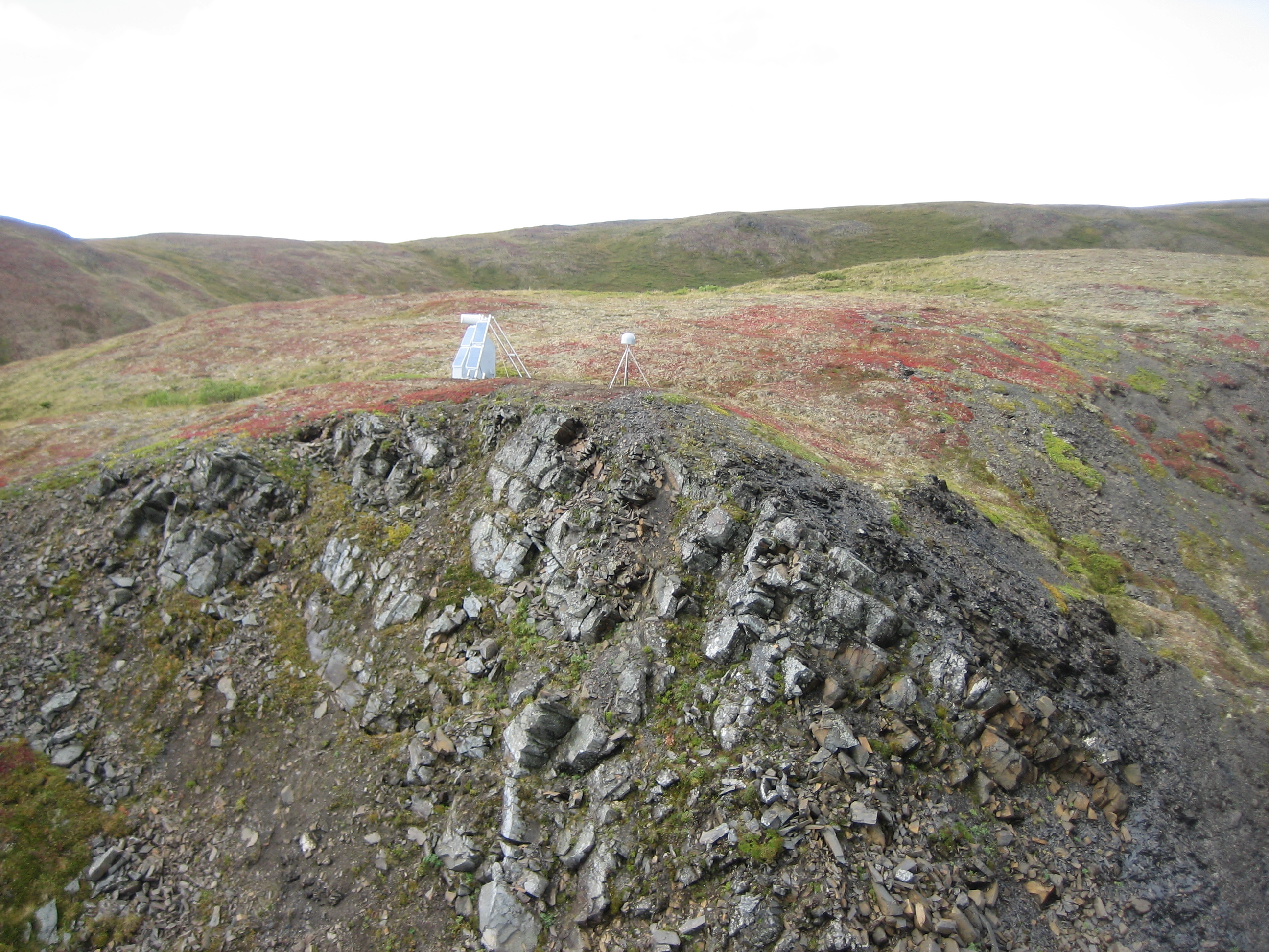
From 2006 to 2010, GPS Station AC55 was located on an elevated area near the bank of the Yentna River in southcentral Alaska. It was part of an immense network of GPS, seismic, and other geophysical instruments comprising the Plate Boundary Observatory (PBO). The PBO was constructed across the western United States and Alaska to help understand processes that occur at plate boundaries, but researchers continue to find new and unexpected ways to utilize the vast publicly accessible data collected from these stations.
“By using the existing infrastructure of the PBO network, we can easily and precisely monitor landslides on the west coast and Alaska,” says Wang
How does it work?
Researchers have used GPS technology to monitor landslides in the last decade, but Wang and his team have updated these methods to take advantage of the PBO infrastructure. Typically, at least one unit like AC55 is placed on and moves with the landslide, providing continuous position data in real time, regardless of the time of day or weather conditions. Another GPS station is installed just outside of the landslide boundaries and acts as a reference. The landslide movement is tracked relative to this reference station, so that researchers can determine how much the landslide moved and in what direction.
But placing a reference station can be challenging, Wang notes. “You may not know the boundary of your landslide,” he says, which may lead to installing the reference station too far away to provide an adequate reference, or possibly installing it on the landslide itself.
To avoid these pitfalls, Wang and his team used as reference stations the permanent GPS monuments of the PBO. Using these stations in concert with AC55, they continuously monitored the landslide near the Yentna River in Alaska over four years.
What is "normal" movement?
Before Wang could determine how much the Yentna River landslide was moving, he first had to account for the “normal” movement in the area. In central Alaska, there is considerable tectonic activity. The Pacific Plate is subducting under the North American plate just south of Alaska, which triggers motion along a number of major faults, including the Denali fault, site of the 2002 magnitude 7.9 Denali quake. In addition to the motion of the plates themselves, residual seismic motion from major earthquakes such as the one in 2002, and even the magnitude 9.2 Great Alaska Earthquake of 1964, affects the landslide area, which is located about 300 km between the earthquake epicenters.
By using different combinations of PBO reference stations near the landslide area, Wang and his team established what they call a “local reference frame.” This accounts for background tectonic movement, which caused reference stations in the area to move an average of 1.5 mm per year. Wang included this information in a series of complex models used to describe the landslide motion.
In addition to tectonic activity, seasonal changes in groundwater level, the amount of water or snow on the surface, and soil moisture can induce periodic ground motion that could be mistaken for landslide movement. A specific point at a reference station near the landslide could be displaced as much as 1.5 cm throughout the year, mostly due to inflation of the ground as it absorbs water from snow melt. Wang and his team included this periodic variation in their models.
Additionally, Wang and his team had to deal with snow and ice accumulation on the GPS antenna, which degrades or bounces the signal. This can cause a delay in receiving the data, making the GPS unit appear to be at an incorrect location at a certain time.
“We don’t try to correct the data, we just find the problem,” says Wang. They identified where data was degraded and removed it from their analysis.
“After you remove the tectonic and seasonal motion and the snow and ice errors,” says Wang, “you are left with the pure landslide movement.” At this point, Wang determined that the Yentna River landslide moved northeastward at about 5.5 cm per year, and also subsided at a rate of 2.6 cm per year.
Not all landslides are fast
“Landslide” is a catch-all word for Earth surface mass movements, but not all landslides involve sliding. Some, for example, involve rotation (rotational slides) or fracturing (lateral spreads). Due to its relatively slow rate of movement, the Yentna River landslide is considered a creeping landslide.
Creeping landslides are common in mountainous areas and can be just as costly as fast-moving landslides. Because they are always in motion, creeping masses can place continuous stress on human infrastructure, making roads inaccessible and damaging utility lines and other property. Short bursts of rapid movement can also occur at these sites. In some cases, communities are unknowingly built on creeping masses, like the Terra Navita neighborhood in Boise, Idaho, whose residents plan to sue developers for failing to consider the area’s previous history with landslides.
Because the Yentna River landslide is in a rural area, Wang and his team were able to fine tune monitoring methods without the added complexity of buildings and roads. These methods could then be applied to creeping masses that pose a threat to communities.
GPS landslide monitoring is not limited to creeping landslides. “It works for slow movements,” says Wang. “Absolutely it works for faster ones.” If recording stations are installed where we expect fast movements to occur, for example on creeping masses or where landslides have occurred in the past, this method could also be used to monitor mountain slides and avalanches. Real-time GPS monitoring may also detect early signs of rapid movement, which could be integrated into a warning system.
Wang’s method of using existing GPS stations to account for background motion could easily be applied to areas with existing long-term networks of recording stations, including much of the United States (PBO, CORS) and Japan (GEONET). In these areas, researchers may be able to identify creeping sites and to assess the potential for landslides to become hazardous.
GPS Station AC55 has since been removed, but others like it will continue to monitor Earth movement as a part of the PBO. Its unanticipated movement at the landslide site draws attention to one of the many ways researchers can make the most of this publicly available infrastructure.


