
By Kerry Klein - Fall 2016
Alaska isn’t always hospitable to newcomers— human or mechanical. Ellie Boyce learned this when she flew out to Augustine Volcano in 2011 to investigate a malfunctioning GPS unit on its slope. Boyce, an engineer with UNAVCO, monitors geodetic stations in Alaska that are part of EarthScope’s Plate Boundary Observatory. When she and her crew arrived at the volcano, they had to dislodge an 800-pound boulder that had rolled against the fiberglass hut housing the electronics. When they returned this past summer, the hut was gone—all that remained were chunks of metal and plastic scattered down the hillside. “We're pretty sure an avalanche just swept it right away,” says Boyce.
Hurtling boulders are some of the many challenges awaiting one of Alaska’s newest arrivals: EarthScope’s Transportable Array (TA). Since 2004, its vast grid of 400 seismometers has rolled methodically across the lower 48 states. Now, the project is entering its final stage: migration to Alaska and northwestern Canada. The TA’s new home is a land of extremes, but with the help of UNAVCO and other organizations already operating in Alaska, the TA’s technology is evolving to meet the demands of a tougher terrain.
The Transportable Array is the centerpiece of USArray, a far-reaching network of sensors logging the seismic and magnetotelluric signals crisscrossing beneath North America. The Transportable Array’s vast quantities of data have yielded hundreds of studies and have been essential for improving earthquake recordkeeping throughout the country. But in some ways the TA’s fruitful first decade was a warm-up, says Andy Frassetto, a project associate with IRIS, which oversees the TA. “The idea was to get some experience,” he says, “before we took on the most challenging environment to work in the U.S.”
Crews installed the first pilot seismometers in Alaska in 2011. The biggest challenge since then, Frassetto says, has been access to field sites. Installing the seismometers is no easy task: each unit requires cementing a sensor into an 8-foot hole drilled or augured into the ground, then housing the sensor, batteries and data communication devices in a tent-shaped plastic hut. In the lower 48 states, Frassetto says, most grid sites are accessible by road, allowing pickup trucks and forklifts to transport the heavy machinery. But in sparsely developed Alaska, the hut, drill rigs and augurs have to be hauled in by helicopter. “We're putting out seismometers on a grid,” Frassetto says. “The grid doesn't care about convenience of getting there.”
The other major obstacle, says Frassetto, is power. In most of the U.S., a rooftop of solar panels and a few backup batteries are sufficient to keep the units running 24 hours a day all year round. But Alaska’s long winters—and high potential for burial under snow—mean each hut has to be equipped with hundreds of pounds of batteries.
Anywhere they’re installed, grid stations require regular monitoring and upkeep. An occasional problem previously, says Frassetto, included vandals using the solar panels for target practice. In Alaska, however, damage is more likely to come from wilder threats—like bears. “We certainly expect some of our sites to be gnawed on at some point,” Frassetto says, “but the most important part of the site, which is the seismometer, would be below ground.”
The remote, extreme nature of the sites makes for exhilarating fieldwork, says Helena Buurman. A station specialist with the University of Alaska Fairbanks, Buurman installed a wave of seismometers around the state this past summer. She and her crew mostly slept in hotels in small villages or remote hunting lodges—and each night was a surprise. “We're putting out equipment and the door of the hut next door has a bearskin drying on it,” she says, “and sheep that are being bled.” New field areas means opportunities to see new places, too—like the Revelation Mountains. “I've done field work for many years in Alaska,” Buurman says, “and I've never flown around mountains like that. Ever.”
The TA’s transition wouldn’t have run nearly as smoothly without its predecessors’ boots already on the ground. When UNAVCO began operating the Plate Boundary Observatory in 2003, it benefitted from the experience of the Alaska Earthquake Center and Alaska Volcano Observatory. It adopted strategies from the two institutions, saving time on permitting and exploring, and redesigned their huts to fit more solar panels. Now, UNAVCO shares some field sites with the TA, and IRIS has already modified its huts to fit the array’s needs. “There's a lot of benefit from collaborating and sharing resources,” UNAVCO’s Ellie Boyce says. “I think we've all found that we can both save money and save time if we just figure out how to do things together—or decide what not to do again.”
So far, field crews have installed or upgraded roughly 60 seismic stations in Alaska. Around 150 more will be placed there, in the Yukon, British Columbia, and the Northwest Territories before the project wraps up in 2018. This may be the TA’s final few years, but Frassetto says the project feels far from over. “In 2016 and 2017, we're going to put out the bulk of the stations. There's a lot to look forward to still,” he says. “We kind of feel like we've got the wind in our sails at this point.” ■
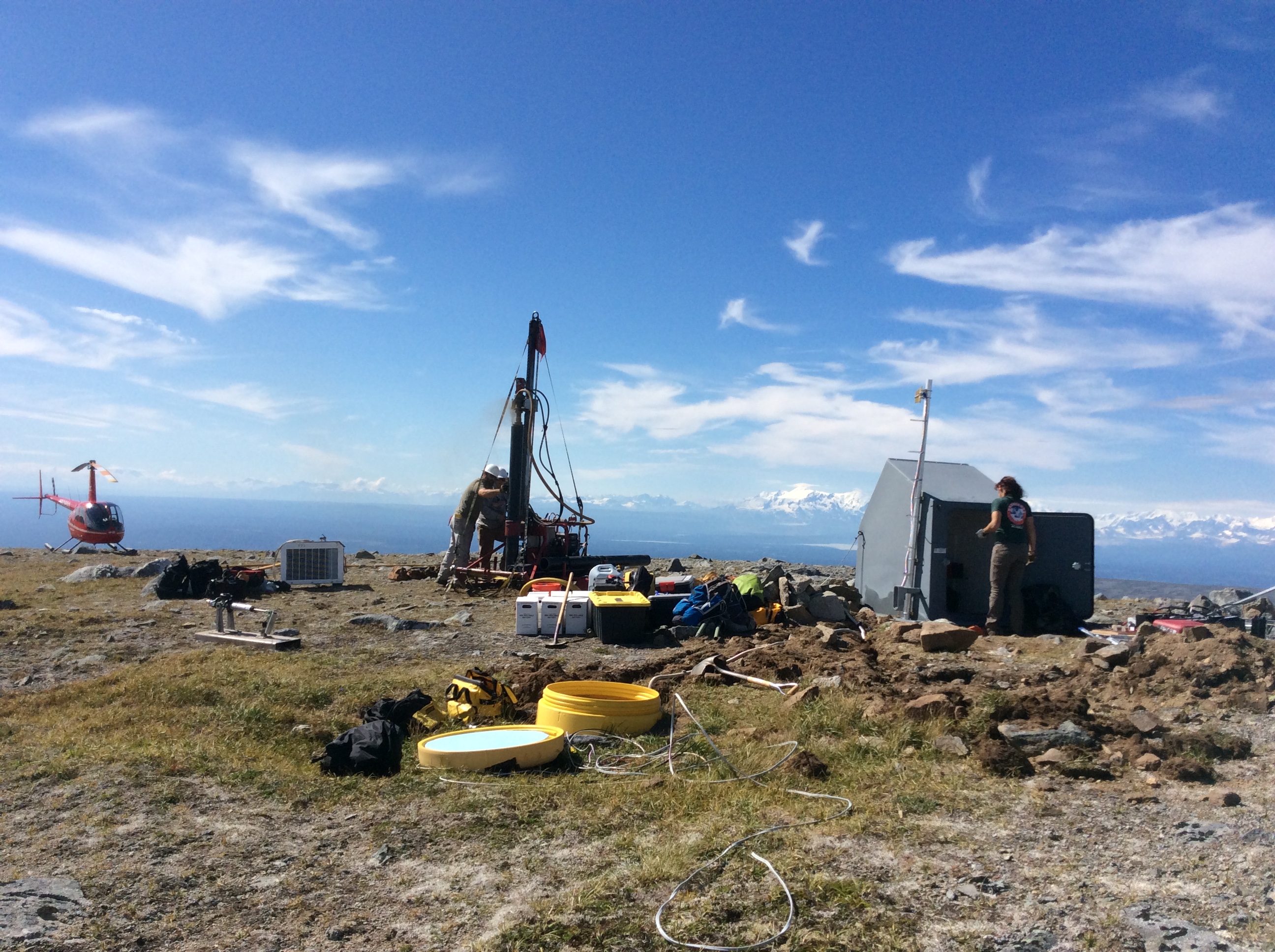
Top picture: TA and Alaska Earthquake Center (AEC) field staff work together to drill a borehole at a southeast Alaska seismic station that is part of the permanent regional seismic network. The seismometer had been installed ~2 feet deep inside the yellow drum (foreground), but in summer 2015 it was repositioned into an 8-foot hole with the help of the drill rig flown in by a helicopter. So far there have been 18 of these "TA upgrades" to regional seismic stations, as well as 38 completely new stations installed. Pictured: Jeremy Miner (TA) and Josh Folmar (GeoTek) operate the drill while Sara Meyer (AEC) works on the communications equipment housed inside the hut. Photo by Helena Buurman.
Read more about EarthScope’s recent activities in Alaska:
Boyce E.S., Bierma R.M., Willoughby H., Feaux K., Mattioli G.S., Enders M., and Busby R.W., 2014. EarthScope's Plate Boundary Observatory in Alaska: building on existing infrastructure to provide a platform for integrated research and hazard-monitoring efforts. American Geophysical Union Fall Meeting, 2014, Abstract T11A-4525. http://search.proquest.com/docview/1696874446?accountid=14470
Driscoll L., Miller M.S., 2014, Crustal and lithospheric thickness variation acrossAlaska in advance of Earthscope Transportable Array. American Geophysical Union Fall Meeting, 2014, Abstract T11A-4524. http://search.proquest.com/docview/1696875294?accountid=14470


