

By Brandon Schmandt, University of New Mexico and Fan-Chi Lin, University of Utah - Spring 2015
One of the major observational components of the EarthScope program is the Transportable Array (TA) network of broadband seismometers. The TA is composed of 400 seismometers that were first installed near the west coast of the U.S. in 2005-2007 and have progressively moved eastward until reaching the northeastern coast of the U.S. during Fall 2013. One of the initial goals of the TA was to enable coast-to-coast seismic imaging of the North America lithosphere and underlying mantle convection with resolution comparable to that within regional observatories. Many more analyses are yet to come, but new travel-time tomography images made with continuous data coverage from southern California to northeastern Maine provide a glimpse of the multi-scale structure of the mantle beneath North America.
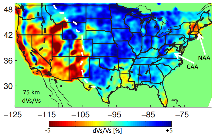
The tomography images shown here use measurements of body waves and surface waves recorded by the TA and other networks in U.S. The body waves used result from distant earthquakes (>3000 km from the TA) and they propagate deep into the Earth before arriving at near vertical angles beneath the TA. The surface waves were extracted from correlations of ambient seismic noise recorded during the approximately two years that each TA station is deployed. Ocean waves are the primary source of the seismic surface wave energy present in ambient noise. By measuring the propagation of both wave types across the TA for a range of frequencies we infer and estimate the 3-D seismic velocity structure beneath North America. Volumes of unusually low velocity mantle dominantly result from warmer than average temperatures at a given depth, and volumes of unusually high velocity result from colder temperatures.
Multiple spatial scales and a long record of geologic time are reflected in the imaged seismic velocity variations. The elevated and tectonically active western U.S. is generally underlain by low-velocity upper mantle indicative of high temperatures and a thin portion of the tectonic plate. High temperatures are further indicated by the widespread presence of Quaternary (< 2 million years old) volcanic rocks in the western U.S. Isolated volumes of high velocity mantle beneath the western U.S. represent subducting slabs or locally thicker parts of the tectonic plate. The central U.S. is generally underlain by high velocity mantle indicative of lower temperatures and a thicker portion of the North America plate. This area has been mostly free of tectonic deformation and magmatic activity since the Precambrian (> 542 million years ago). Intermediate seismic velocities are found beneath the eastern margin of the U.S., which has not been an active plate boundary since the Atlantic Ocean began to open about 200 million years ago.
Prior to the arrival of the TA, seismic sampling of the passive margin of the eastern U.S. was sparse compared to the western U.S. and little was known about variations in upper mantle temperature. Interest in thermal convection beneath the passive margin is stimulated by geological evidence for magmatic events and evolving topography long after the area became a passive margin. Initial images of seismic structure beneath the passive margin detect two distinct upper mantle low velocity anomalies beneath the central and northern Appalachians, respectively. These relatively high temperature volumes probably reflect lasting thermal scars in the lithosphere from magmatic events that occurred approximately 45 – 125 million years ago.
Sustained geodynamic activity along passive margins is not predicted (or precluded) by plate tectonic theory, rather it is largely a consequence of mantle convection beneath a plate’s interior. This makes it difficult to understand the long-term geological evolution of the eastern U.S. without constraints on thermal structure and flow in the mantle. EarthScope seismic data are already advancing our understanding of the western U.S. where plate margin processes are the primary drivers and are now beginning to advance understanding of the passive margin in the eastern U.S. where the major driving forces are less evident at the surface.


