
The EarthScope facilities maintain ~100 Campaign GPS systems and ~2100 broadband and short-period FlexArray seismic sensors. The Campaign/Flexible instruments allow for focused observation and study of key geophysical locales and are available to the scientific community through proposals approved by the NSF. EarthScope Data is freely-accessible data and data products from thousands of geophysical instruments that measure motions of the Earth's surface, record seismic waves, and recover rock samples from depths at which earthquakes originate. EarthScope's use of advanced instrumentation permits us to answer some of the outstanding questions in Earth sciences by looking deeper, increasing resolution, and integrating diverse measurements and observations.
UNAVCO maintains 100 campaign GPS systems in order to support portable GPS deployments funded by the NSF's EarthScope Science panel. Based on Topcon GB-1000 equipment, the systems have been designed for stand-alone temporary or semi-permanent deployment that will be used for densifying areas not sufficiently covered by continuous GPS and for responding to volcanic and tectonic crises. UNAVCO provides support for all aspects of these projects, including proposal and budget development, project planning, equipment, field support, training, and data archiving.
Find more information about the GPS campaigns and previous researchs on UNAVCO PBO Campaigns page.
A pool of portable seismic instruments, referred to as the Flexible Array, is supported out of the USArray Array Operations Facility (AOF), collocated with the PASSCAL Instrument Center in Socorro, NM. Because the Flexible Array no longer exists as a distinct pool under the current cooperative agreement with NSF (SAGE), it has been merged into the overall PASSCAL instrument pool. The Flexible Array has available to the research community ~2146 instruments (326 broadband, 120 short period, and 1700 active source) that can be deployed using flexible source-receiver geometries. Using both natural and active sources, these additional portable instruments permit high-density, short-term observations of key targets within the footprint of the larger Transportable Array. USArray's flexible component offers exciting opportunities for a variety of focused investigations requiring higher-resolution images embedded within the context of the Transportable Array.
Many important geologic targets are amenable to investigation with the Flexible Array, including the depth extent of faults, magma chamber dimensions beneath active volcanoes, the relation between crustal tectonic provinces and mantle structure, the shape of terrain boundaries, the deep structure of sedimentary basins and mountain belts, and the structure and magmatic plumbing of continental rifts. Linked with coordinated geological, geochemical, and geodetic studies, the Flexible Array will also address a wide range of problems in continental geodynamics, tectonics, and earthquake processes.
Flexible Array PIs can find information on instrument availability, data-use policy, an instrument request form, and more on the PASSCAL Instrument Center Website.
Flexible Array Request Form
Flexible Array Data Policy
Flexible Array Information for the PI
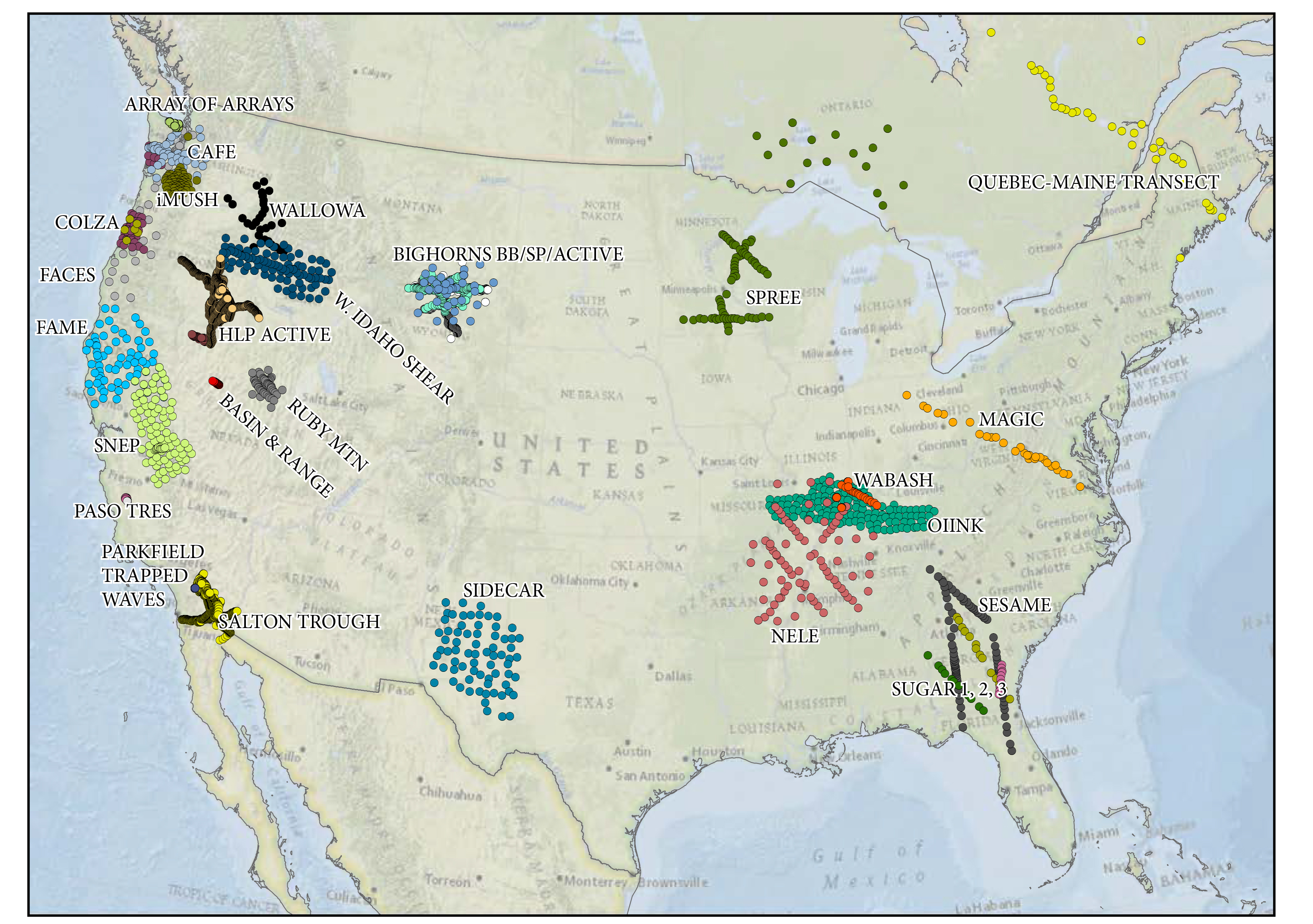
Click on this map to see its interactive version
List of Current and Past Experiment Profiles
Flexible Array Stations Google Map
List of Flexible Array Stations
If you have links, information, or changes to make, please contact EarthScope Office: uaf-earthscope[at]alaska.edu


