
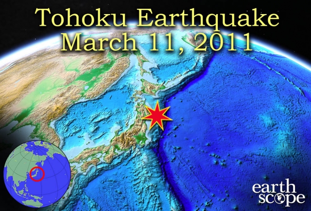
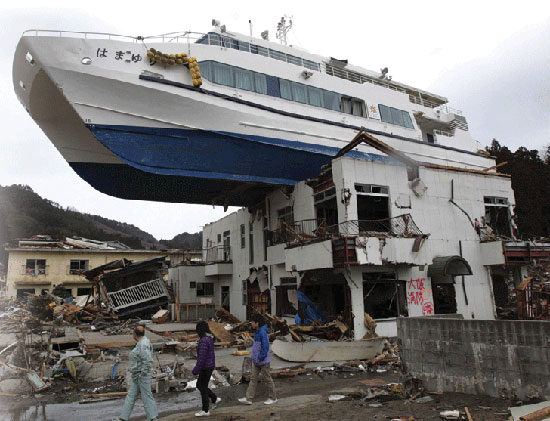
On Friday March 11, 2011, a 9.0 magnitude earthquake struck the east coast of Honshu, Japan from Chiba to Aomori. Over 20,000 people were killed, 6000 were injured, and the earthquake displaced 140,000 people. Over 500,000 buildings and structures were damaged or destroyed by the earthquake and resulting tsunami. Electricity, water, food, and gas supplies were disrupted by the quake, accompanied by telecommunications and transportation failure. Multiple nuclear reactors were severely damaged as well, and endangered population centers near the nuclear power grid. Fires, dam failure, landslides, and soil liquefaction also accompanied the earthquake. The tsunami that followed the initial shaking obliterated many coastal towns and cities, and spread to locations across the world, including Hawaii, California, Oregon, the Galapagos Islands, Ecuador, Peru, Chile, and Antarctica. Shaking from the earthquake was felt as far as the Northern Mariana Islands, North Korea, South Korea, Taiwan, northeastern China, and southeastern Russia. Water fluctuations and seiches were observed in Norway and Canada (USGS “Magnitude 9.0 – Near the east coast of Honshu, Japan”).
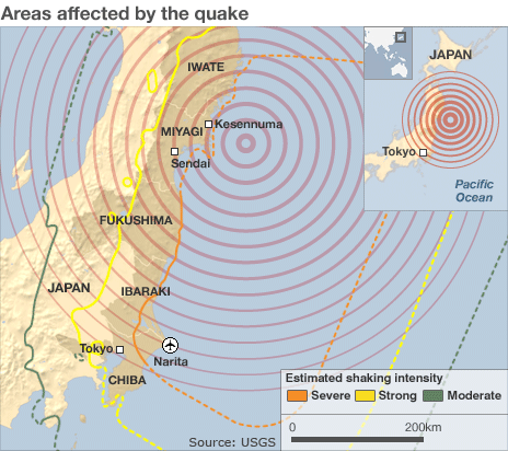
Image above retrieved from BBC news.
The 9.0 magnitude earthquake was the highest to hit Japan in recorded history, with hundreds of aftershocks were recorded after the main event. It is currently the 5th largest recorded earthquake since 1900. The earthquake epicenter was at a depth of approximately 30 kilometers (18.6 miles) just off the east coast of Honshu, Japan. The earthquake was a result of the thrust faulting near the convergent plate boundary between the Pacific Plate and the North American Plate. The Pacific Plate subducts beneath the North American Plate at approximately 83 mm per year, and descents east of Japan forming the Japan Trench. A 6 to 8 meter upthrust along the seabed 60 kilometers offshore resulted in the widespread tsunami that propagated throughout the Pacific Ocean to neighboring continents. The tsunami was significantly more damaging than the earthquake, and caused the majority of the deaths and damage associated with the event.
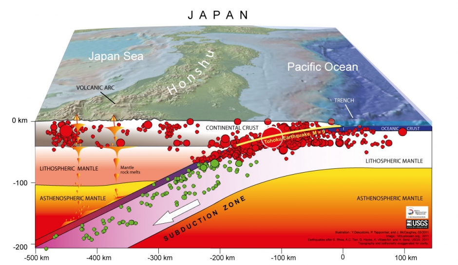
Image above courtesy of the Earth Observatory of Singapore Blog .
The image above depicts some of the geologic deformation of the local rocks and structures due to the earthquake.
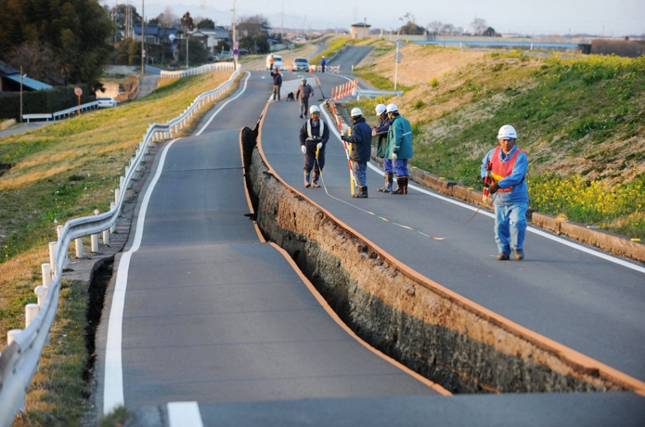
The 9.0 magnitude earthquake resulted in devastating human and economic losses, with shortages of food, water, healthcare, and fuel causing difficulties for the displaced survivors. The Tohoku earthquake is one of the most observed and recorded earthquakes of its magnitude, and provided a large quantity of information to seismologists and geologists around the world. According to Tom Brocher, center director to the USGS Earthquake Science Center in Menlo Park, “The investment by the Japanese government in earthquake monitoring instrumentation yielded an unprecedented scientific and engineering data bonanza that will help the Japanese to mitigate damage from future earthquakes” (USGS, “The March 11 Tohoku Earthquake, One Year Later. What Have We Learned?” March 9, 2012). Japan is currently updating its tsunami and earthquake disaster preparedness plans to take into consideration paleo-tsunami deposits of the same scale as the 9.0 magnitude Tohoku quake, and to mitigate the damage they risk to settlements of coastal Japan. Seismologists in the United States have learned from the tsunami and are using data collected from the Tohoku earthquake to understand and use information on natural hazards along the Cascadia Subduction Zones and the Alaska-Aleutian subduction zone regions. Regions prone to high magnitude earthquakes and tsunamis include Alaska, British Columbia, Washington, Oregon, and Northern California.
Convergent plate boundaries are a driving force for orogenic processes, seismic activity, magmatism (volcanic activity) and continental accretion of ocean island arcs. These processes are what build the continents and environments around the world, though they can result in death, destruction, and general mayhem in major human population centers. The March 11, 2011 9.0 magnitude Tohoku earthquake demonstrates the results of these powerful processes, and further research by scientists and organizations around the world will shed more light on the driving forces and frequency of these events. EarthScope, UNAVCO, and IRIS help observe and interpret tectonic plate movement and geologic events. EarthScope monitors many plate boundaries with the Plate Boundary Observatory (PBO) system. The movement of the plates, seismic activity, volcanic activity, and other geologic events are observed and analyzed by researchers around the country. The Plate Boundary Observatory is maturing to a decade old, so many of the GPS time series tell compelling stories. Sites in the Pacific Northwest show the signature of subduction including episodic tremor and slip, sites in California shear along the San Andreas fault, sites on Yellowstone and other volcanoes move up and down as magma moves and erupts, and sites throughout the network have captured earthquakes. This information will help scientists to determine and predict the exact causes of seismic activity and volcanic activity, as well as the geology and inner-earth movements that contribute to plate tectonics. (Information courtesy of UNAVCO and EarthScope). The images below depict the Tohoku earthquake in more detail.
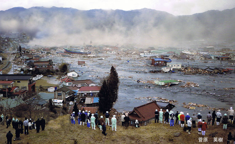
Local residents watch the tsunami.
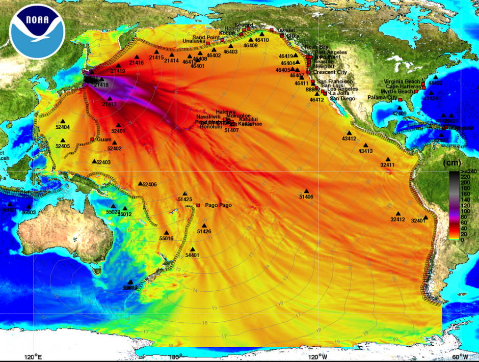
Tsunami propagation during the 2011 Tohoku earthquake, courtesy of NOAA.


