
Articles
2019
Derek Schutt
2019-07-11
Wait, I could do geophysics—physics and math—and go outside?! That's the perfect combination.
Fifteen Years of Earth Science Exploration
2019-02-14
The EarthScope National Office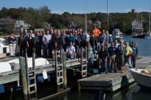
Reflections on the Accomplishments of EarthScope’s USArray
2019-02-14
The USArray has operated for over 15 years as a community science facility designed to address EarthScope’s goal of understanding the structure and evolution of the North American continent.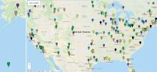
Education Corner: Final inSights Issue
2019-02-14
Sharing Science through the EarthScope Speaker Series and Save the Date for the EarthScope Legacy Education and Outreach Virtual Workshop2018

New EarthScope Video!
2018-12-12
15 Years of Geoscience Discovery and Education in North America
EarthScope Top 10 Discoveries
2018-12-07
,
Redrawing the Map of the Midcontinent Rift
2018-09-04
EarthScope data is changing our views of this billion-year-old feature
Media Advisory
2018-05-24
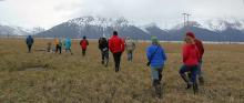
Science Educators Gather in Anchorage to Learn about Teaching and Preparing for Earthquakes, Tsunamis, and Volcanoes in Alaska
EarthScope Announcements
2018-05-04
inSights Spring 2018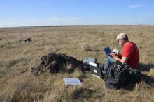
Mapping North America’s Magnetic Personality
2018-05-02
Completing a Cross-Country Dataset of Magnetotelluric Observations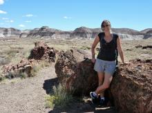
Emily Hopper
2018-03-06
Humans of EarthScope: "The stuff we’re researching is fundamental to how the whole planet functions."
Open SESAME
2018-01-29
EarthScope seismic research inspires landowners and students in Georgia
EarthScope Announcements
2018-01-29
inSights Winter 2017-18
Inter-Agency Collaborations Take Center Stage at EarthScope Transportable Array Meeting in Alaska
2018-01-28
New Alaska data reaches beyond earthquakes
Rob Hawman
2018-01-24
I got into geology originally because I was always fascinated by the history of the earth.2017

Education Corner
2017-10-12
In every InSights issue, ESNO features two of the dozens of tools, modules, and activities that utilize EarthScope data to benefit a wide variety of users (K–12, university educators, informal programs like museums or after-school programs).
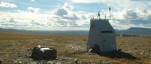
EarthScope's Transportable Array Spans Alaska, the Last Frontier
2017-10-12
Elliot Wilson of Pioneer Earthworks operates the drill at Alaska Transportable Array station D27M. Photo by Max Enders, IRIS.
A Writing Intern in the Field
2017-10-11
As the science writing intern for the EarthScope National Office, field work is not generally a part of my job..jpg?itok=UB8Zhy_G)
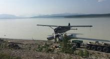
By road, boat, plane and helicopter: Creating a remote seismic measurement network
2017-10-03
Want to dig deeper? Click on the "advanced" button in the article for scientific details.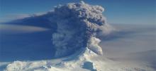
The Quiet After the Storm
2017-07-26
How EarthScope’s infrasound and seismic capabilities monitor evolving volcanic eruptionsedited.jpg?itok=WcA_Q6ML)
Transportable Array Equips Stations with Infrasound Sensors
2017-07-25
by Andy Frassetto and Kasey Aderhold, IRIS - NSF # SAGE: 1261681, MRI-R2: 0960275 | Summer 2017
Observations of infrasonic signals have…
EarthScope's Final National Meeting
2017-06-16
A culmination of 15 years of expansive geoscience research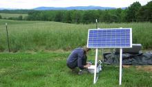
Earthquakes on a Passive Margin
2017-05-05
How EarthScope data help reveal the roots of anomalous seismic zones in the southeastern U.S.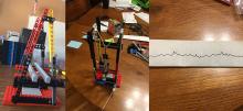
Seismology in the Classroom
2017-05-05
A new online course connects teachers across Alaska to real-time seismic data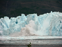
Calving Season
2017-04-03
How EarthScope seismometers help track glacier breakdown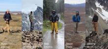
The Alaska Transportable Array Team
2017-02-01
Achieving Success in Challenging Environments
Winter 2017 Education Corner
2017-02-01
In every InSights issue, ESNO features two of the dozens of tools, modules, and activities that utilize EarthScope data to benefit a wide variety of users (K–12, university educators, informal programs like museums or after-school programs)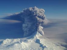
Volcano study examines relationship between seismic signals, sound waves
2017-01-23
By Sue Mitchell - University of Alaska Fairbanks Press Release - January 17, 2017 (http://news.uaf.edu/hearing-a-volcanic-plume/)
A study of relationships between seismic signals and sound
2016
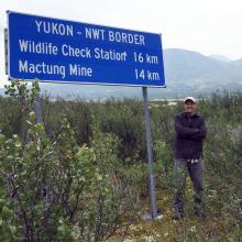
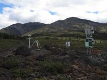
Driving the Dempster
2016-10-24
The Transportable Array deploys along a remote Canadian “highway”
Fall 2016 Education Corner
2016-10-23
For every InSights issue, we feature two of the dozens of tools, modules, and activities that utilize EarthScope data to benefit a wide variety of users. We intend to reach K–12 and university educators, as well as informal programs like museums.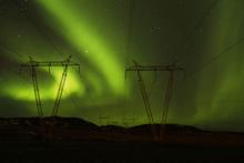
A Magnetic Meeting of Space and Earth
2016-09-20
Magnetic storms, triggered by the interaction of the solar wind with Earth’s magnetosphere, not only produce our aurora light shows, but can also induce electric fields in our planet’s subsurface.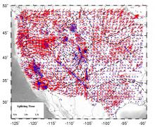
Mantle Anisotropic Structure and Dynamics Beneath the Western United States
2016-09-19
Constraints from Shear-wave Splitting Analysis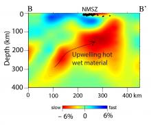
Hot, Wet Mantle Below the New Madrid Seismic Zone
2016-09-19
Science Nugget - By Charles Langston (University of Memphis), Christine Powell (University of Memphis), Steve Horton (University of Memphis), Heather Deshon (Southern Methodist…,
IRIS 2016 Workshop
2016-09-01
Highlights Emerging Fields and Technologies in Seismology2015
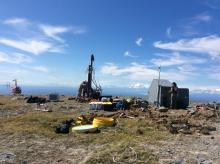
Supporting Earth Science in the Canadian Sub-Arct
2015-12-01
By Justin Sweet - Winter 2016
Canada’s Yukon and Northwest Territories are not known as hospitable land. This sub-arctic region, home to the Mackenzie Mountains project, presented
Alaska Bound
2015-09-22
Transportable Array migrates northward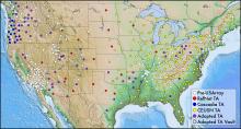
The Legacy of the USArray Transportable Array
2015-04-13
By Andy Frassetto, IRIS - Spring 2015
In the fall of 2003, before EarthScope began, approximately 200 modern broadband seismic stations operated across the contiguous United States,

A Coast-to-Coast View of the Mantle Beneath the United States
2015-04-01
By Brandon Schmandt, University of New Mexico and Fan-Chi Lin, University of Utah - Spring 2015
One of the major observational components of the EarthScope program is the…
2014
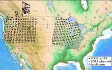
USArray Continues Field Activities in 2014
2014-10-14
By Perle Dorr, IRIS - Summer 2014
Since the completion of the Transportable Array in the Lower 48 during fall 2013, USArray has focused on the creation of the Central and Eastern US
Workshop Report: Modern and Ancient Basement Arches and the Connection to Flat Slab Subduction
2014-09-22
By Megan Anderson (CC), Kate Miller (TAMU), Susan Beck (UA), and Margarete Jadamec (UH) - Fall 2014
The structural dissimilarity between basement-involved arches and thin…
Transportable Array Contributes to the Central and Eastern US Network
2014-03-22
By Perle Dorr, IRIS - Spring 2014
The National Science Foundation is funding the creation of a Central and Eastern US Network (CEUSN) for the purpose of obtaining long-…
Earthquakes and Human Activities Addressing Public Concerns
2014-03-22
North Texas Earthquake Study Group, Southern Methodist University - Spring 2014
There is currently public, scientific, and policy concern regarding the recent increased…
New Flexible Array Video Series
2014-01-01
By ESNO - Winter 2014
Geology might not be the first thing that comes to mind if you heard the names SESAME, CAFÉ, SUGAR, and OIINK, but these are just a few examples of…
2013
USArray Reaches the East Coast
2013-12-22
By Maureen Long and Vadim Levin - Winter 2014
On October 1st 2013 the seismic and magnetotelluric observatory network USArray, which is a key element of the EarthScope…
USArray Looks Back as it Looks Ahead
2013-09-22
By IRIS - Fall 2013
Ten years ago, the construction of USArray observatories officially began. This followed numerous community meetings, countless hours of meticulous…
SPREE: A Seismic Study of Continental Modification
2013-06-22
Trevor Bollmann, Emily Wolin, Suzan van der Lee, and the SPREE Team - Summer 2013
Northwestern University, Washington University in St. Louis, the University of Minnesota…
USArray - Alaska Deployment Planning
2013-06-22
Terry Pavlis, UTEP - Spring 2013
On February 19 and 20 approximately 50 geoscientists met at the Pacific Geoscience Center in Sydney, British Columbia, to discuss…
USArray Infrasound Data Products at IRIS
2013-06-22
By Manochehr Bahavar and Chad Trabant - Summer 2013
Diverse natural and man-made acoustic sources such as large explosions, rocket launches, and meteorites can act as…
USArray Status
2013-03-22
By Perle Dorr, IRIS
With operating stations blanketing the southeastern states, the Transportable Array is on target to complete its journey across the contiguous US and…
Chelyabinsk Meteor lit up the Transportable Array
2013-03-22
By Catherine D. de Groot-Hedlin and Michael Hedlin - Spring 2013
The large meteorite that entered Earth's atmosphere above Chelyabinsk, Russia last month drew attention…
USArray Detects Hurricane Sandy
2013-01-01
By IRIS - Winter 2013
The USArray’s Transportable Array (TA) seismometers and barometers have documented ground motion and atmospheric pressure changes due to Hurricane…
2012
Understanding Continental Evolution using Data from the Transportable Array
2012-09-22
By Dr.Hersh Gilbert - Fall 2012
Do high mountains possess thick roots of low-density crust that keep them a"oat in the denser mantle, or do zones of low-density mantle…
Mineral, VA Earthquake Demonstrates the Passive Aggressive Margin of Eastern North America
2012-03-22
By Meghan Berg - Spring 2012
On August 23, 2011, the Mw 5.8 Mineral, Virginia, earthquake rocked the east coast of the U.S. While moderate in comparison to recent mega-…
Spring 2012 Facilities Status
2012-03-22
Spring 2012
USArray Status
The Transportable Array (TA) continues to roll eastward across the US. Having crossed the Mississippi River in March 2011, the TA will…
2011
Seismic Tomography with USArray Data
2011-08-16
In its July 2011 issue, Popular Science ranked EarthScope the “most epic” big science project because of its ambitious scope: Exploration of the deep geologic structure and evolution of an entire continent.2010
U-Pb Thermochronology: 4-Dimensional Imaging of the North American Lithosphere
2010-03-22
As the USArray Transportable Array marches eastward, seismic images are providing ever more detailed insight into present day structures of the crust and mantle beneath North America. But how old are these structures and what do they tell us about the geo

