
.jpg)
Access to SALMON station SALA in western Cook Inlet, showing challenging conditions. At high tide, all the rocks in view are underwater. Here a three-wheeler pulling a trailer is being driven onto the boat at a falling tide. Note the typical bluffs in the background; these bluffs posed challenging access to sites on top.(Credit C.Tape)
Researchers: Carl Tape, Douglas Christensen, and Kyle Smith, University of Alaska Fairbanks; Melissa M. Moore-Driskell, University of North Alabama; Justin Sweet, IRIS
The Southern Alaska Lithosphere and Mantle Observation Network (SALMON) is a 2015-2017 deployment of 28 broadband, direct-burial posthole seismometers in the Cook Inlet region of the southern Alaska subduction zone. Here we describe the objectives of the project, the deployment strategy, and station design. We analyze time-dependent and frequency-dependent seismic noise for the first year of data at 18 SALMON stations, 11 of which are inside Cook Inlet basin, 7 of which are outside the basin. We compare noise at SALMON stations with four previous co-located seismic stations, two Transportable Array stations, and one Global Seismographic Network station. The type of site--notably surface bedrock versus sedimentary basin--has the strongest impact on seismic noise levels across all periods and especially on horizontal components at long periods (>20 s). Seismic noise and earthquakes recorded by SALMON stations reveal amplification of seismic waves in Cook Inlet basin. Aftershocks of a Mw 7.1 intraslab earthquake augment a catalog of local earthquakes to be used for source inversions and seismic imaging of the complex seismic structure in the Cook Inlet region.
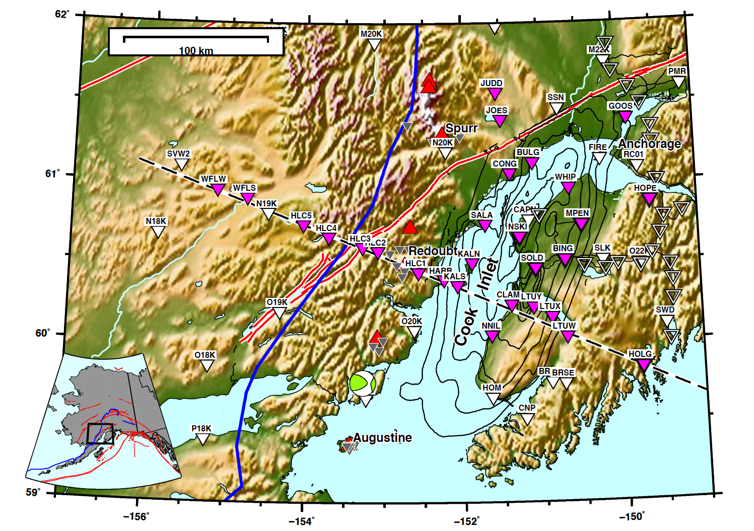
Broadband stations in the Cook Inlet region, January 2017. The absence of roads west of Cook Inlet poses challenges for accessing stations. Magenta inverted triangles denote SALMON (network ZE) stations in this study. Solid white triangles denote permanent stations and stations within the temporary Transportable Array. Open white triangles denote sites from the MOOS experiment from 2007–2009 (Abers and Christensen, 2006; Li et al., 2013; Kim et al., 2014). Gray triangles denote intermediate-period stations from the volcanic network (AV). Active volcanoes are plotted as red triangles, with labels for Augustine, Redoubt, and Spurr. The thick dashed line is the 2D target profile from Holgate glacier (HOLG) in the east, through Redoubt Volcano (elevation 3108 m), and to Sparrevohn (AT.SVW2) in the west. Contours (1 km increment) are for the Cook Inlet basin, which has a maximum depth of 7.6 km (Shellenbaum et al., 2010). Active faults are plotted as thick red lines (Koehler et al., 2012). The thick blue line, trending approximately north-south, marks the western lateral extent of intraslab seismicity. The beachball shows the source mechanism for the 2016-01-24 Mw 7.1 Iniskin earthquake, which occurred within the Pacific slab at a depth of about 110 km (Ekström et al., 2012). Kodiak Island, which hosts stations II.KDAK.00 and II.KDAK.10 used in our study, is just south of the region and can be seen in the inset map.
REFERENCES:
Tape, C., D. Christensen, M. M. Driskell, 2015, Southern Alaska Lithosphere and Mantle Observation Network, International Federation of Digital Seismograph Networks. Other/Seismic Network. doi:10.7914/SN/ZE_2015
Tape, C., D. Christensen, M. M. Moore-Driskell, J. Sweet, and K. Smith, 2017, Southern Alaska Lithosphere and Mantle Observation Network (SALMON): A seismic experiment covering the active arc by road, boat, plane, and helicopter, Seismological Research Letters, v. 88, No. 4, p. 1185-1202, doi:10.1785/0220160229
Grant: NSF EAR 1251971; Duration of the Project : 10/1/2013 to 9/30/2018 ; ES instruments: Transportable Array FlexArray; Location: Alaska, Anchorage, Cook Inlet


