
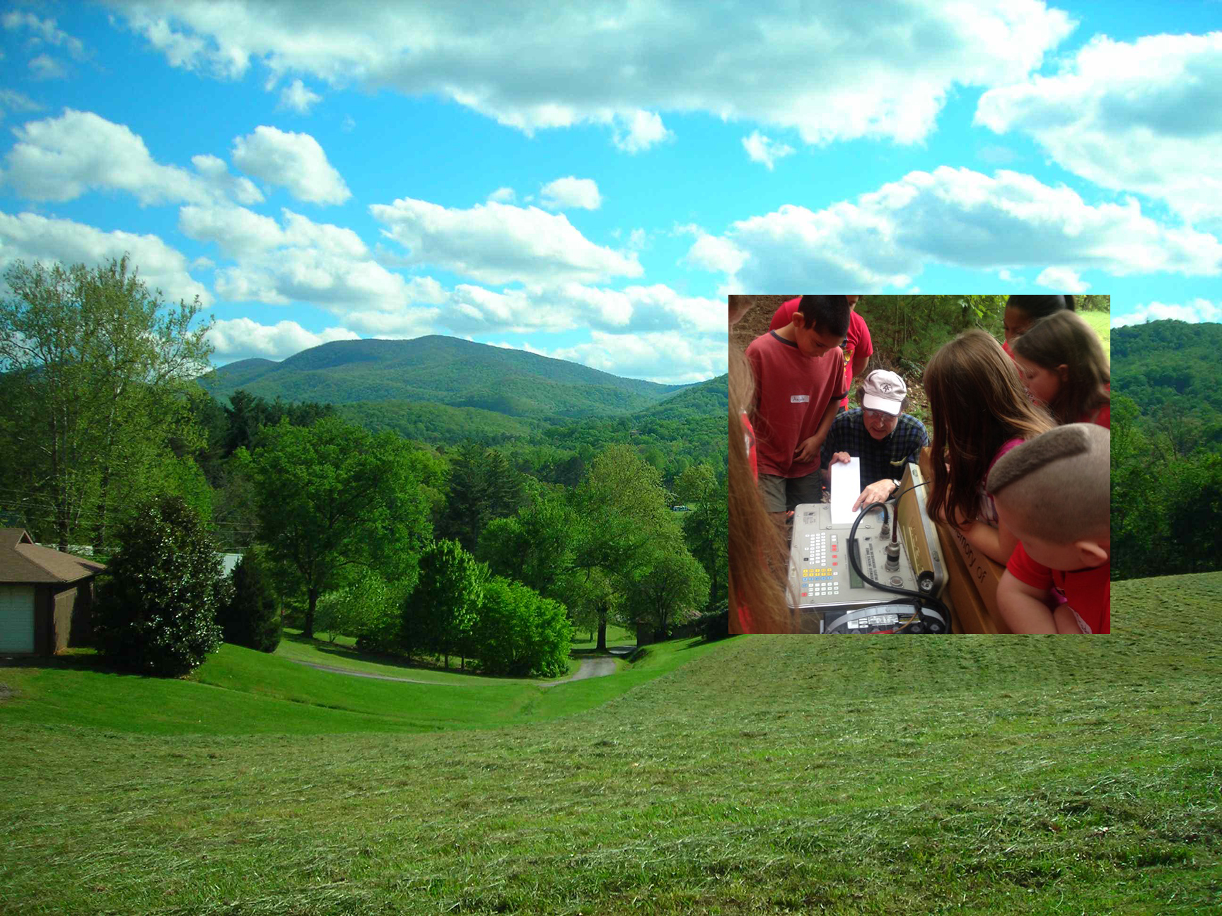
Background: View of the Georgia Mountain Research & Education Center (GMREC), where rural schoolkids come to learn about the environment. (Photo by Rob Hawman)
Inset: Fourth-grade students examine seismograms for an "earthquake" they have generated during an outdoor Environmental Field Day event at GMREC, near Blairsville, GA. (Image from Peggy Schneider, GMREC Community Council).
by Beth Grassi
Science field work sometimes takes unexpected directions. For EarthScope researcher Rob Hawman, that’s what happened with the Southeastern Suture of the Appalachian Margin Experiment (SESAME). Delving into the origins of the Appalachian Mountains, one of the oldest mountain ranges in the U.S., utilized some of the newest geophysical instruments. Hawman found that setting up the field stations required building strong connections with local landowners. He didn’t anticipate those connections would lead to introducing thousands of the youngest residents of the region to seismic research through outdoor education that continues to inspire a new generation of scientists.
The SESAME project, funded by the National Science Foundation through the EarthScope program, ran from 2010 to 2014. Hawman is a professor in the Department of Geology at the University of Georgia who specializes in field-based geophysics. He and his fellow researchers on the SESAME project, Karen Fischer of Brown University and Lara Wagner of University of North Carolina–Chapel Hill (now at the Department of Terrestrial Magnetism, Carnegie Institution for Science), used a network of broadband seismic stations to collect seismic images to investigate relicts of the processes that formed the edge of North America.
The EarthScope grant provided access to the Flexible Array component of the USArray network of seismic instruments. The Flexible Array is portable, allowing scientists to set up intensive, short-term research projects. For the SESAME team, this entailed installing two long lines of instruments that crossed the suspected region where the ancient continents of Gondwana (which eventually became Africa and South America) and Laurentia (which eventually became North America) first collided and later separated, creating the Appalachian Mountains we see today. Differences between fossil types as well as rock ages and types indicated to researchers that the “suture,” or seam that joined the continents, exists in Georgia, but the actual location had not been directly observed before this EarthScope project.
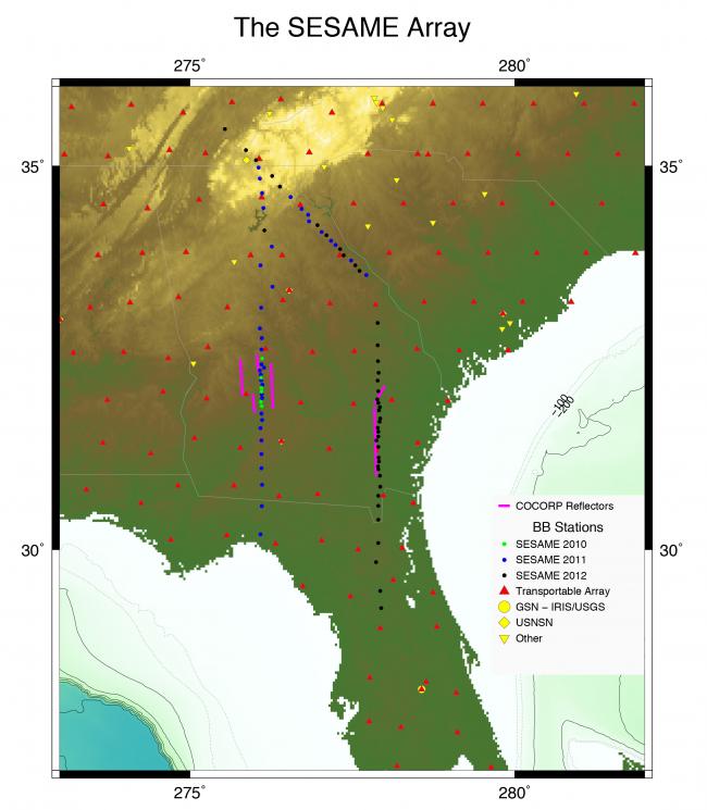
This map shows the dense, targeted configuration of the Flexible Array stations installed for the SESAME project. (Map prepared by Karen Fischer and Julia MacDougall, Brown University)
Making Connections through EarthScope
Hawman was charged with locating the sites for the 85 seismic instruments that the SESAME Flexible Array project would install. In the southeastern U.S., most of the seismic stations are on small, private lands, many of them farms. The initial contact with landowners was through a cover letter introducing the project and explaining what the researchers needed. Hawman and graduate student Horry Parker followed that up with personal visits.
“I thought it was important to do a good public relations job, to follow up and visit and spend time with people,” Hawman said. He would often spend an afternoon talking to a landowner. “I learned a lot about farming in the Southeast,” he said with a laugh. Most landowners were receptive from the start, though some needed a little prodding. “Everyone turned out to be really nice and were open-minded about the project.”
Keeping landowners engaged throughout the project was an important component. Throughout the project, Hawman’s team stayed in contact with landowners, every year sending a property-specific report and recording to each landowner.
Hawman’s approach of building and fostering connections with landowners hosting seismic stations paid off in more ways than he originally anticipated, leading to opportunities to also work with elementary and middle school students.
Future Seismologists
Hawman’s involvement with teaching kids about seismology started with a serendipitous meeting at the Georgia Mountain Research & Education Center in the Blue Ridge Mountains near Blairsville, Georgia. Hawman contacted the education center about hosting a seismic station, thinking it might eventually lead to some sort of outreach opportunities. It did—just a few days later.
“I got this slightly panicked call from the Education Center that they had 250 kids coming in a couple of days and they wanted to know if we could help out,” Hawman said. The Education Center holds Science and Environmental Field Days for elementary and middle schools in rural counties of Georgia. At the event, students move through a series of stations covering everything from stream ecology to seismology. Groups of 15 to 25 students spend an intensive 20 minutes at each station.
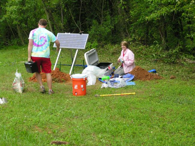
Karen Fischer (Brown University) and Davison Hogan (University of Georgia graduate student) installing station W34 at the Georgia Mountain Research & Education Center in May 2011. (Photo by Julia G. MacDougall)
Another education site came about through a connection with an individual landowner. One of the seismic stations was located on a large farm in Lincoln County; the owner also happened to be a bus driver for the local school district. He was enthusiastic about the EarthScope project, which led to a number of field trips for sixth-grade science classes from Lincoln County schools to visit the site on his property.
“What we do is just in-your-face science, not anything super technical,” Hawman said. He’s worked to refine the activities “so we accurately portray what happens during an earthquake in a hands-on way.”
One activity that captures students’ attention is a simple setup (inspired by seismologist Richard Allen) using a slinky attached to a block of wood and a fly-fishing reel to show fault slip. The block rests on a board. The friction of the wooden block on the board initially resists the pull of the slinky, so the slinky stretches as the student cranks the reel, storing elastic strain energy, just as rock stores energy prior to an earthquake. When the strain becomes great enough, the block finally overpowers the friction and slides forward, releasing the pent-up energy.
“The kids are really, really curious,” Hawman said. “The more gizmos you can show them, the more interested they are. Just talking at them for 20 minutes is the kiss of death.”
Students participate in several activities (see the lesson plan here), culminating in working with simple seismometers. Hawman and his helpers set up an array of a dozen or so seismometers along the path by the demonstration area, hooked up to a seismograph. The students jump in sequence to create an “earthquake,” and then practice reading the seismograms.
“They can look at a record of multiple seismograms and tell in what direction the wave is traveling—which is impressive for middle schoolers—and this shows why it’s important to have an array of instruments,” said Hawman.
Over the years, Hawman has worked to fine-tune the activities to make them age-appropriate. He found that what appeals to seventh graders is very different than what entices fourth graders. The activities dovetail with what teachers cover in their classroom earth science classes. Hawman has refined the materials and now has posters, demonstrations, and illustrations along with summaries of the principles that teachers can use in the classroom.
Carrying on EarthScope’s Lessons
As of October 2017, Hawman’s team had worked with more than 2,150 elementary and middle school students at outdoor events held at the Georgia Mountain Research & Education Center and at the SESAME instrument site in Lincoln County.
Hawman and his graduate and undergraduate students continue to participate in the Science Center events twice a year. “It’s good for them to know that members of our faculty are willing to do that, to get out and spend time with folks,” said Hawman. Many of the graduate and undergraduate students may go on to become teachers, and the outdoor science days give them practice at making science fun and hands on. “The challenge is making it fun and interesting while keeping it rigorous,” said Hawman. He plans to expand the elementary and middle school education efforts to schools in southern Georgia.
Why is education at this level important? “If you ask undergrads how they got interested in earth science, many of them say it goes back to childhood experiences,” Hawman said. “When you get a kid in elementary or middle school interested, somewhere in the back of their mind they will remember what captured their interest. You never know when what you say will spark something in their imagination.”
Learn More
What inspired Rob Hawman to become a geophysicist? Learn more on the Humans of EarthScope webpage.
Learn more about the SESAME project.
Read some of the most recent publications resulting from the SESAME project:
Imaging crustal structure beneath the southern Appalachians with wavefield migration. Hopper, E., K. M. Fischer, S. Rondenay, R. B. Hawman, and L. S. Wagner (2016), Geophys. Res. Lett., 43, 12,054–12,062, doi:10.1002/2016GL071005.
Estimating crustal thickness using SsPmp in regions covered by low-velocity sediments: Imaging the Moho beneath the Southeastern Suture of the Appalachian Experiment (SESAME) array, SE Atlantic Coastal Plain (2016), Parker, E.H., R. B. Hawman, K. M. Fischer, and L. S. Wagner, Geophys. Res. Lett., 43, doi:10.1002/2016GL070103.
NSF funding sources: EAR-0844276 (Karen Fischer), EAR-0844186 (Lara Wagner), EAR-0844154 (Rob Hawman)
Principal Investigators for the SESAME project: Karen Fischer (Brown University), Donald Forsyth (Brown University), Lara Wagner (University of Carolina–Chapel Hill), Rob Hawman (University of Georgia)


